TopoQuest Logo
Do you find TopoQuest useful?
Help keep TopoQuest running and adding new maps/features by donating!
Bitcoin:  19c7KJd3qBynnjoSw5npx9KScwjBe4ifkT
Litecoin:  LXs6TkuXGGXo1vDsWCkWVdjQX94eUKd6ui
Home View Maps Find Maps Find Places Resources & Links


Lennep, Montana Topographic Map

USGS Map Title: Lennep, MT
USGS Map MRC: 46110D5
DRG (GeoTIFF) Download: o46110d5.tif


Neighboring USGS Topographic Map Quads:


  Fourmile Spring, MT  
46110E6
 

  Checkerboard, MT  
46110E5
 

  Mount Howe, MT  
46110E4
 

  Castle Town, MT  
46110D6
 

  Lennep, MT  
46110D5
 

  Groveland, MT  
46110D4
 

  Hamen, MT  
46110C6
 

  Rimrock Divide, MT  
46110C5
 

  Lebo, MT  
46110C4


Map MRC Location:

N47°
W111°
N47°
W110°
H8 H7 H6 H5 H4 H3 H2 H1
G8 G7 G6 G5 G4 G3 G2 G1
F8 F7 F6 F5 F4 F3 F2 F1
E8 E7 E6 E5 E4 E3 E2 E1
D8 D7 D6 D5 D4 D3 D2 D1
C8 C7 C6 C5 C4 C3 C2 C1
B8 B7 B6 B5 B4 B3 B2 B1
A8 A7 A6 A5 A4 A3 A2 A1
N46°
W111°
N46°
W110°

Lennep, MT USGS 1:24K Topographic Map Preview:
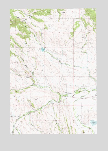
Lennep, MT USGS Topographic Map
Click on map above to begin viewing in our Map Viewer.

This topographic map contains these locations and features:
Feature Name Type Latitude Longitude GNIS ID View Map
08N10E32____01 WellWellN46.4102°W110.5010°816094View Map
Alabaugh CreekStreamN46.4138°W110.5524°778899View Map
Bonanza (historical)LocaleN46.4583°W110.5841°1762819View Map
Bonanza CreekStreamN46.4408°W110.5160°780203View Map
Bonanza DamDamN46.4583°W110.5774°796270View Map
Bonanza RanchLocaleN46.4505°W110.5574°794029View Map
Bonanza ReservoirReservoirN46.4595°W110.5782°780207View Map
Bozeman Fork Musselshell RiverStreamN46.3827°W110.6199°780343View Map
Comb ButteSummitN46.3761°W110.5205°781533View Map
Comb CreekStreamN46.4177°W110.5105°781534View Map
Comb Creek School (historical)SchoolN46.4105°W110.5216°1762767View Map
Corral CreekStreamN46.4358°W110.5933°781697View Map
Coyote CreekStreamN46.4408°W110.5160°781812View Map
Deer CreekStreamN46.4063°W110.5649°782240View Map
Freemans (historical)LocaleN46.3986°W110.5869°1762753View Map
LennepPopulated PlaceN46.4161°W110.5433°786050View Map
Lennep (historical)LocaleN46.4161°W110.5433°1762745View Map
Lennep Elementary SchoolSchoolN46.4161°W110.5449°1762827View Map
Lennep Post Office (historical)Post OfficeN46.4161°W110.5433°1762708View Map
Lennup CemeteryCemeteryN46.4110°W110.5341°1762896View Map
Martinsdale-Ringling DivisionCivilN46.4079°W110.6178°1940668View Map
North Fork Bonanza CreekStreamN46.4861°W110.6196°788101View Map
Robinson CreekStreamN46.4241°W110.5910°789648View Map
Sawmill CreekStreamN46.3961°W110.5977°790059View Map
Slaughter House CreekStreamN46.4222°W110.5752°790640View Map
South Fork Bonanza CreekStreamN46.4861°W110.6196°790912View Map
Trinity Lutheran ChurchChurchN46.4174°W110.5452°1762841View Map
Voldseth RanchLocaleN46.3933°W110.5271°794035View Map
Voldseth ReservoirReservoirN46.3862°W110.5047°792732View Map
Voldseth West DamDamN46.3866°W110.5074°796268View Map

Note: Coordinates in the location and feature list above are referenced to NAD83 datum.


Copyright (C) 2008-2025 Ryan Niemi / Sunset Dynamics ... All Rights Reserved