TopoQuest Logo
Do you find TopoQuest useful?
Help keep TopoQuest running and adding new maps/features by donating!
Bitcoin:  19c7KJd3qBynnjoSw5npx9KScwjBe4ifkT
Litecoin:  LXs6TkuXGGXo1vDsWCkWVdjQX94eUKd6ui
Home View Maps Find Maps Find Places Resources & Links


Lillie, Louisiana Topographic Map

USGS Map Title: Lillie, LA
USGS Map MRC: 32092H6
DRG (GeoTIFF) Download: o32092h6.tif


Neighboring USGS Topographic Map Quads:


  Wesson, AR  
33092A7
 

  Junction City, AR  
33092A6
 

  Lockhart, LA  
33092A5
 

  Summerfield, LA  
32092H7
 

  Lillie, LA  
32092H6
 

  Spearsville, LA  
32092H5
 

  Lisbon, LA  
32092G7
 

  Bernice, LA  
32092G6
 

  Shiloh, LA  
32092G5


Map MRC Location:

N33°
W93°
N33°
W92°
H8 H7 H6 H5 H4 H3 H2 H1
G8 G7 G6 G5 G4 G3 G2 G1
F8 F7 F6 F5 F4 F3 F2 F1
E8 E7 E6 E5 E4 E3 E2 E1
D8 D7 D6 D5 D4 D3 D2 D1
C8 C7 C6 C5 C4 C3 C2 C1
B8 B7 B6 B5 B4 B3 B2 B1
A8 A7 A6 A5 A4 A3 A2 A1
N32°
W93°
N32°
W92°

Lillie, LA USGS 1:24K Topographic Map Preview:
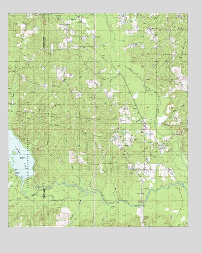
Lillie, LA USGS Topographic Map
Click on map above to begin viewing in our Map Viewer.

This topographic map contains these locations and features:
Feature Name Type Latitude Longitude GNIS ID View Map
Bear CreekStreamN32.9218°W92.7360°547034View Map
Beaver CreekStreamN32.9946°W92.6815°46267View Map
Beech Grove CemeteryCemeteryN32.9975°W92.6287°544045View Map
Beech Grove ChurchChurchN32.9976°W92.6296°547049View Map
Bethel CemeteryCemeteryN32.9607°W92.7118°544047View Map
Bethel ChurchChurchN32.9599°W92.7121°547064View Map
Bethel SpringsPopulated PlaceN32.9610°W92.7113°1630744View Map
Big BranchStreamN32.8982°W92.6988°547074View Map
CopleyPopulated PlaceN32.8779°W92.6354°547247View Map
Corney LakeReservoirN32.9190°W92.7480°554092View Map
Corney Lake Picnic AreaLocaleN32.9068°W92.7460°1630040View Map
Davis CreekStreamN32.9954°W92.6640°547292View Map
Dry CreekStreamN32.8979°W92.6993°547317View Map
Evergreen ChurchChurchN32.9940°W92.6968°554374View Map
Farrar BranchStreamN32.8913°W92.6729°547353View Map
Field BranchStreamN32.8999°W92.7307°547358View Map
Hammock CreekStreamN32.8943°W92.6949°547432View Map
Hard Shell CemeteryCemeteryN32.9704°W92.6399°547435View Map
Jenks BranchStreamN32.9407°W92.6479°547521View Map
Kidd LakeLakeN32.8984°W92.7319°1630041View Map
Lee CreekStreamN32.9663°W92.6657°547570View Map
LilliePopulated PlaceN32.9321°W92.6568°547585View Map
Lillie Middle School (historical)SchoolN32.9138°W92.6540°548716View Map
Lillie Post OfficePost OfficeN32.9318°W92.6554°1630769View Map
Lillie Volunteer Fire DepartmentBuildingN32.9310°W92.6565°2673024View Map
Little Cornie BayouStreamN32.8985°W92.6282°51227View Map
Lowery CreekStreamN32.8885°W92.6818°547634View Map
Mill CreekStreamN32.9915°W92.6690°52000View Map
Parish Governing Authority District 9CivilN32.9079°W92.6814°1930286View Map
Pilgrim ChurchChurchN32.9918°W92.6524°547836View Map
Pilgrims Rest CemeteryCemeteryN32.9915°W92.6522°544062View Map
RandolphPopulated PlaceN32.9865°W92.6904°547879View Map
Rum CenterPopulated PlaceN32.9901°W92.6518°538763View Map
Saint John ChurchChurchN32.9401°W92.7085°547925View Map
Spring BranchStreamN32.8974°W92.6515°548018View Map
Steep Bank CreekStreamN32.9471°W92.6260°548035View Map
Taylor CemeteryCemeteryN32.9771°W92.7493°548065View Map
Thompson BranchStreamN32.9151°W92.6304°548075View Map
Union Grove CemeteryCemeteryN32.9315°W92.6738°544069View Map
Union Grove ChurchChurchN32.9324°W92.6743°548107View Map
Village of LillieCivilN32.9220°W92.6613°2407490View Map
Ward NineCivilN32.9007°W92.6810°545237View Map
Wards Mill (historical)Populated PlaceN32.9871°W92.7396°548735View Map

Note: Coordinates in the location and feature list above are referenced to NAD83 datum.


Copyright (C) 2008-2025 Ryan Niemi / Sunset Dynamics ... All Rights Reserved