TopoQuest Logo
Do you find TopoQuest useful?
Help keep TopoQuest running and adding new maps/features by donating!
Bitcoin:  19c7KJd3qBynnjoSw5npx9KScwjBe4ifkT
Litecoin:  LXs6TkuXGGXo1vDsWCkWVdjQX94eUKd6ui
Home View Maps Find Maps Find Places Resources & Links


Sussex, Virginia Topographic Map

USGS Map Title: Sussex, VA
USGS Map MRC: 36077H3
DRG (GeoTIFF) Download: o36077h3.tif


Neighboring USGS Topographic Map Quads:


  Carson, VA  
37077A4
 

  Templeton, VA  
37077A3
 

  Disputanta South, VA  
37077A2
 

  Stony Creek, VA  
36077H4
 

  Sussex, VA  
36077H3
 

  Littleton, VA  
36077H2
 

  Jarratt, VA  
36077G4
 

  Yale, VA  
36077G3
 

  Sebrell, VA  
36077G2


Map MRC Location:

N37°
W78°
N37°
W77°
H8 H7 H6 H5 H4 H3 H2 H1
G8 G7 G6 G5 G4 G3 G2 G1
F8 F7 F6 F5 F4 F3 F2 F1
E8 E7 E6 E5 E4 E3 E2 E1
D8 D7 D6 D5 D4 D3 D2 D1
C8 C7 C6 C5 C4 C3 C2 C1
B8 B7 B6 B5 B4 B3 B2 B1
A8 A7 A6 A5 A4 A3 A2 A1
N36°
W78°
N36°
W77°

Sussex, VA USGS 1:24K Topographic Map Preview:
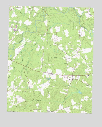
Sussex, VA USGS Topographic Map
Click on map above to begin viewing in our Map Viewer.

This topographic map contains these locations and features:
Feature Name Type Latitude Longitude GNIS ID View Map
Beaver Pond SwampStreamN36.9902°W77.3308°1462945View Map
Bethel CemeteryCemeteryN36.9557°W77.3019°1463152View Map
Bethel Methodist Church (historical)ChurchN36.9554°W77.3028°1690177View Map
Black Branch SwampStreamN36.9929°W77.2930°1463473View Map
BookerPopulated PlaceN36.9396°W77.2847°1499152View Map
Booker School (historical)SchoolN36.9482°W77.2955°1690183View Map
Briggs Mill (historical)LocaleN36.8979°W77.2666°1690184View Map
Cabin Point SwampStreamN36.9704°W77.3325°1464231View Map
Comans WellLocaleN36.8774°W77.3153°1465130View Map
Courthouse DistrictCivilN36.8960°W77.2880°1927162View Map
Gosee SwampStreamN36.9965°W77.3241°1467275View Map
Hargraves DamDamN36.9001°W77.2664°1490940View Map
Hargraves MillpondReservoirN36.8997°W77.2683°1490941View Map
Howells MillPopulated PlaceN36.8890°W77.3303°1499582View Map
Hunting Quarter CemeteryCemeteryN36.8990°W77.3486°1690212View Map
Hunting Quarter ChurchChurchN36.8996°W77.3483°1468401View Map
LambsPopulated PlaceN36.9915°W77.2564°1499641View Map
Moores SwampStreamN36.9888°W77.2711°1470721View Map
Mush Pond SwampSwampN36.9297°W77.3483°1471284View Map
New Hope Baptist ChurchChurchN36.9082°W77.2547°1471434View Map
New Hope CemeteryCemeteryN36.9076°W77.2544°1690234View Map
Oven BranchStreamN36.9940°W77.2652°1471981View Map
Reidville CemeteryCemeteryN36.9124°W77.2811°1690246View Map
Reidville ChurchChurchN36.9129°W77.2805°1473141View Map
Rowanty CreekStreamN36.9713°W77.3461°1473602View Map
Sharon ChurchChurchN36.8776°W77.3158°1474438View Map
SussexPopulated PlaceN36.9151°W77.2791°1498541View Map
Sussex Census Designated PlaceCensusN36.9174°W77.2719°2629041View Map
Sussex Central High SchoolSchoolN36.9200°W77.2538°1464689View Map
Sussex Central Middle SchoolSchoolN36.9201°W77.2562°1690256View Map
Sussex Count Courthouse Historic DistrictParkN36.9151°W77.2794°1690259View Map
Sussex CountyCivilN36.9218°W77.2618°1690257View Map
Sussex County CourthouseBuildingN36.9149°W77.2797°1690258View Map
Sussex County Office of Public SafetyBuildingN36.9154°W77.2799°2331847View Map
Sussex County Sheriff's OfficeBuildingN36.9156°W77.2804°2085903View Map
Sussex County Sheriff's OfficeBuildingN36.9155°W77.2807°2332009View Map
Sussex Courthouse Volunteer Fire DepartmentBuildingN36.9135°W77.2803°2331727View Map
Sussex Post OfficePost OfficeN36.9153°W77.2792°2519656View Map
Thweatt BranchStreamN36.9013°W77.2714°1475700View Map
West HopePopulated PlaceN36.9210°W77.3116°1477868View Map

Note: Coordinates in the location and feature list above are referenced to NAD83 datum.


Copyright (C) 2008-2025 Ryan Niemi / Sunset Dynamics ... All Rights Reserved