TopoQuest Logo
Do you find TopoQuest useful?
Help keep TopoQuest running and adding new maps/features by donating!
Bitcoin:  19c7KJd3qBynnjoSw5npx9KScwjBe4ifkT
Litecoin:  LXs6TkuXGGXo1vDsWCkWVdjQX94eUKd6ui
Home View Maps Find Maps Find Places Resources & Links


Lonesome Peak, Montana Topographic Map

USGS Map Title: Lonesome Peak, MT
USGS Map MRC: 45105C5
DRG (GeoTIFF) Download: o45105c5.tif


Neighboring USGS Topographic Map Quads:


  Epsie, MT  
45105D6
 

  Epsie NE, MT  
45105D5
 

  Broadus, MT  
45105D4
 

  Yarger Butte, MT  
45105C6
 

  Lonesome Peak, MT  
45105C5
 

  Eldon Mountain, MT  
45105C4
 

  Huckins School, MT  
45105B6
 

  Baldy Peak, MT  
45105B5
 

  Bear Skull Mountain, MT  
45105B4


Map MRC Location:

N46°
W106°
N46°
W105°
H8 H7 H6 H5 H4 H3 H2 H1
G8 G7 G6 G5 G4 G3 G2 G1
F8 F7 F6 F5 F4 F3 F2 F1
E8 E7 E6 E5 E4 E3 E2 E1
D8 D7 D6 D5 D4 D3 D2 D1
C8 C7 C6 C5 C4 C3 C2 C1
B8 B7 B6 B5 B4 B3 B2 B1
A8 A7 A6 A5 A4 A3 A2 A1
N45°
W106°
N45°
W105°

Lonesome Peak, MT USGS 1:24K Topographic Map Preview:
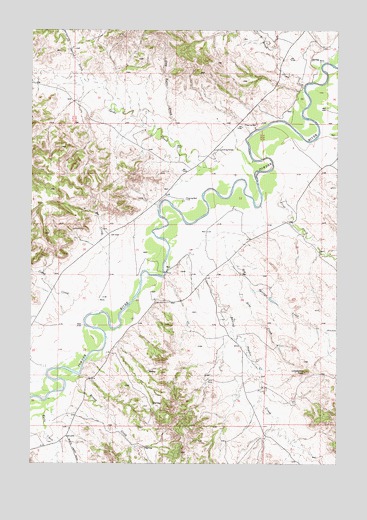
Lonesome Peak, MT USGS Topographic Map
Click on map above to begin viewing in our Map Viewer.

This topographic map contains these locations and features:
Feature Name Type Latitude Longitude GNIS ID View Map
05S50E26DA__01 WellWellN45.3653°W105.5030°809108View Map
05S50E26DDA_02 WellWellN45.3650°W105.5117°809105View Map
05S50E26DDAB01 WellWellN45.3661°W105.5064°809114View Map
05S50E26DDBA01 WellWellN45.3639°W105.5117°809101View Map
05S50E27ABDD01 WellWellN45.3736°W105.5319°809165View Map
05S50E35CBDD01 WellWellN45.3519°W105.5211°809054View Map
06S50E01ABBD01 WellWellN45.3478°W105.5386°809036View Map
06S50E01BCDC01 WellWellN45.3411°W105.5486°809011View Map
06S50E12CADC01 WellWellN45.3233°W105.5417°808930View Map
06S50E13CDDD01 WellWellN45.3078°W105.5392°808843View Map
06S50E14CCBD01 WellWellN45.3067°W105.5686°808837View Map
06S50E15BD__01 WellWellN45.3130°W105.5839°808875View Map
06S50E16AAAC01 WellWellN45.3175°W105.5956°808901View Map
06S50E21ACDA01 WellWellN45.2983°W105.5483°808797View Map
06S50E21CDDD01 WellWellN45.2900°W105.6028°808746View Map
06S50E24CC__01 WellWellN45.2897°W105.5453°808745View Map
06S50E32DDCB01 WellWellN45.2619°W105.6181°808631View Map
06S50E36AAA_01 WellWellN45.2744°W105.5308°808679View Map
06S51E05BB__01 WellWellN45.3464°W105.5128°809033View Map
06S51E06AC__01 WellWellN45.3386°W105.5108°809002View Map
06S51E06BDAB01 WellWellN45.3436°W105.5194°809020View Map
06S51E31CCCC01 WellWellN45.2617°W105.5267°808627View Map
07S50E01BDBB01 WellWellN45.2567°W105.5458°808609View Map
Baking Powder CreekStreamN45.3083°W105.5556°768466View Map
Bog Springs CreekStreamN45.3150°W105.5464°769079View Map
Butte CreekStreamN45.2694°W105.6178°769443View Map
Cache CreekStreamN45.3355°W105.5544°780760View Map
Cedar CreekStreamN45.2947°W105.6072°769707View Map
Clay Butte CreekStreamN45.3428°W105.5664°769912View Map
Deep Gulch CreekStreamN45.2755°W105.6056°1690004View Map
Dobe CreekStreamN45.3064°W105.5417°770682View Map
Dripping Spring CreekStreamN45.3603°W105.6047°770751View Map
Ernest CreekStreamN45.2753°W105.6047°771240View Map
First CreekStreamN45.3289°W105.5261°771376View Map
Flood CreekStreamN45.2903°W105.6239°771472View Map
Lonesome PeakSummitN45.2769°W105.5133°773621View Map
Moores (historical)Populated PlaceN45.2686°W105.5972°1721486View Map
North Bar CreekStreamN45.3069°W105.5944°774674View Map
Rough CreekStreamN45.3580°W105.5139°775967View Map
Second CreekStreamN45.3444°W105.5022°776323View Map
Upper Daily CreekStreamN45.2942°W105.5778°1690003View Map
Wilson CreekStreamN45.3472°W105.5756°1690002View Map

Note: Coordinates in the location and feature list above are referenced to NAD83 datum.


Copyright (C) 2008-2025 Ryan Niemi / Sunset Dynamics ... All Rights Reserved