TopoQuest Logo
Do you find TopoQuest useful?
Help keep TopoQuest running and adding new maps/features by donating!
Bitcoin:  19c7KJd3qBynnjoSw5npx9KScwjBe4ifkT
Litecoin:  LXs6TkuXGGXo1vDsWCkWVdjQX94eUKd6ui
Home View Maps Find Maps Find Places Resources & Links


Long Branch, Tennessee Topographic Map

USGS Map Title: Long Branch, TN
USGS Map MRC: 35087B4
DRG (GeoTIFF) Download: o35087b4.tif


Neighboring USGS Topographic Map Quads:


  Ovilla, TN  
35087C5
 

  Deerfield, TN  
35087C4
 

  Ethridge, TN  
35087C3
 

  Westpoint, TN  
35087B5
 

  Long Branch, TN  
35087B4
 

  Lawrenceburg, TN  
35087B3
 

  Saint Joseph, TN  
35087A5
 

  Loretto, TN  
35087A4
 

  Bonnertown, TN  
35087A3


Map MRC Location:

N36°
W88°
N36°
W87°
H8 H7 H6 H5 H4 H3 H2 H1
G8 G7 G6 G5 G4 G3 G2 G1
F8 F7 F6 F5 F4 F3 F2 F1
E8 E7 E6 E5 E4 E3 E2 E1
D8 D7 D6 D5 D4 D3 D2 D1
C8 C7 C6 C5 C4 C3 C2 C1
B8 B7 B6 B5 B4 B3 B2 B1
A8 A7 A6 A5 A4 A3 A2 A1
N35°
W88°
N35°
W87°

Long Branch, TN USGS 1:24K Topographic Map Preview:
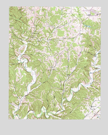
Long Branch, TN USGS Topographic Map
Click on map above to begin viewing in our Map Viewer.

This topographic map contains these locations and features:
Feature Name Type Latitude Longitude GNIS ID View Map
Ander Smith CemeteryCemeteryN35.1854°W87.3842°1275674View Map
Bailey CemeteryCemeteryN35.2117°W87.4611°1276097View Map
Bailey SpringSpringN35.1829°W87.4403°1276117View Map
Bealer BranchStreamN35.2281°W87.4345°1269321View Map
Beech Grove ChurchChurchN35.2206°W87.4659°1305056View Map
Belew CemeteryCemeteryN35.1651°W87.4200°1276895View Map
Bennett LakeReservoirN35.2284°W87.3928°1277018View Map
Bennett Lake DamDamN35.2279°W87.3889°1307086View Map
Bird BranchStreamN35.1926°W87.4886°1277501View Map
Boswell BranchStreamN35.2123°W87.4806°1278019View Map
Boswell CemeteryCemeteryN35.2273°W87.4664°1278021View Map
Brushy CreekStreamN35.2145°W87.4759°1278701View Map
Cedar Hill CemeteryCemeteryN35.1490°W87.3925°1641970View Map
Cedar Hill ChurchChurchN35.1487°W87.3917°1305777View Map
Christian Home OrphanageBuildingN35.2412°W87.3892°1305923View Map
Collier CemeteryCemeteryN35.1917°W87.4045°1280972View Map
Commissioner District 5CivilN35.1855°W87.3810°2464465View Map
Coplin HollowValleyN35.1606°W87.3948°1281255View Map
Crews BranchStreamN35.1545°W87.4745°1281612View Map
Crews CemeteryCemeteryN35.1962°W87.4506°1306175View Map
CrewstownPopulated PlaceN35.1801°W87.4411°1281616View Map
Crewstown Church of ChristChurchN35.1804°W87.4417°1308158View Map
Crockett School (historical)SchoolN35.2365°W87.4064°1302992View Map
David Corckett Elementary SchoolSchoolN35.2409°W87.3792°1302994View Map
Drake HollowValleyN35.1564°W87.4261°1282778View Map
Dryden HollowValleyN35.1624°W87.3900°1283033View Map
Durham SpringSpringN35.1795°W87.4425°1283233View Map
Eagle School (historical)SchoolN35.1954°W87.3822°1302997View Map
GandyPopulated PlaceN35.2201°W87.4039°1285129View Map
Gandy Volunteer Fire DepartmentBuildingN35.2182°W87.4061°2653791View Map
Goslin BranchStreamN35.1454°W87.4836°1285727View Map
Granddaddy CreekStreamN35.2354°W87.4870°1285820View Map
Grassy BranchStreamN35.1976°W87.4795°1285874View Map
Greenbrier BranchStreamN35.1709°W87.4189°1286144View Map
Hollander BranchStreamN35.1259°W87.4742°1288066View Map
Hollis HollowValleyN35.1349°W87.4482°1288076View Map
Houser CemeteryCemeteryN35.2284°W87.4431°1288496View Map
Hughes HollowValleyN35.1333°W87.4412°1288677View Map
Ike BranchStreamN35.1637°W87.4567°1288910View Map
Kilburn CemeteryCemeteryN35.2223°W87.4772°1290146View Map
Knob CreekPopulated PlaceN35.1826°W87.4789°1315339View Map
Knob CreekStreamN35.1281°W87.4928°1290377View Map
Knob Creek ChurchChurchN35.1823°W87.4789°1641994View Map
Knob Creek ChurchChurchN35.2284°W87.4992°1290383View Map
Lawrence CountyCivilN35.2173°W87.3956°1639764View Map
Limekiln HollowValleyN35.1881°W87.4838°1291293View Map
Little Spring CreekStreamN35.2112°W87.4475°1291674View Map
Long BranchPopulated PlaceN35.1562°W87.4247°1291864View Map
Long BranchStreamN35.1473°W87.4270°1291867View Map
Long Branch ChurchChurchN35.1740°W87.4172°1291910View Map
Long Branch School (historical)SchoolN35.1590°W87.4242°1317738View Map
Luna CemeteryCemeteryN35.2145°W87.4722°1292279View Map
McClain CemeteryCemeteryN35.1915°W87.4822°1293139View Map
Mount LebanonPopulated PlaceN35.2465°W87.4661°1315550View Map
Mount Lebanon CemeteryCemeteryN35.2467°W87.4558°1294659View Map
Mount Lebanon ChurchChurchN35.2462°W87.4661°1642007View Map
Mount ZionPopulated PlaceN35.1487°W87.4792°1315561View Map
Mount Zion CemeteryCemeteryN35.1506°W87.4817°1642011View Map
Mount Zion ChurchChurchN35.1501°W87.4772°1641951View Map
Neal CemeteryCemeteryN35.1429°W87.4989°1295277View Map
Nelson BranchStreamN35.1951°W87.3814°1295365View Map
Nelson CemeteryCemeteryN35.1962°W87.3825°1295369View Map
Payne CemeteryCemeteryN35.1854°W87.4806°1297005View Map
Pea RidgePopulated PlaceN35.2159°W87.4661°1297027View Map
Pea Ridge CemeteryCemeteryN35.2323°W87.4667°1642016View Map
Pea Ridge Church of ChristChurchN35.2159°W87.4656°1642017View Map
Piney BranchStreamN35.2354°W87.4870°1297613View Map
Pleasant Point School (historical)SchoolN35.1348°W87.3856°1317740View Map
Poplar BranchStreamN35.1295°W87.4450°1298168View Map
Rigsby HollowValleyN35.2000°W87.3795°1299446View Map
Salem ChurchChurchN35.2420°W87.3784°1300545View Map
Salem Church (historical)ChurchN35.2490°W87.3959°1303050View Map
Sam Smith CemeteryCemeteryN35.1790°W87.3900°1300625View Map
Shack LakeReservoirN35.1278°W87.3774°1301140View Map
Shack Lake DamDamN35.1265°W87.3764°1307061View Map
Spring CreekPopulated PlaceN35.2131°W87.4472°1271063View Map
Spring CreekStreamN35.2081°W87.4753°1271066View Map
Spring Creek School (historical)SchoolN35.2131°W87.4417°1303059View Map
Springers StationPopulated PlaceN35.1390°W87.3870°1303775View Map
Troup BranchStreamN35.2112°W87.4475°1272910View Map
Whitehouse BranchStreamN35.1984°W87.3778°1274420View Map

Note: Coordinates in the location and feature list above are referenced to NAD83 datum.


Copyright (C) 2008-2024 Ryan Niemi / Sunset Dynamics ... All Rights Reserved