TopoQuest Logo
Do you find TopoQuest useful?
Help keep TopoQuest running and adding new maps/features by donating!
Bitcoin:  19c7KJd3qBynnjoSw5npx9KScwjBe4ifkT
Litecoin:  LXs6TkuXGGXo1vDsWCkWVdjQX94eUKd6ui
Home View Maps Find Maps Find Places Resources & Links


Ovilla, Tennessee Topographic Map

USGS Map Title: Ovilla, TN
USGS Map MRC: 35087C5
DRG (GeoTIFF) Download: o35087c5.tif


Neighboring USGS Topographic Map Quads:


  Topsy, TN  
35087D6
 

  Riverside, TN  
35087D5
 

  Henryville, TN  
35087D4
 

  Waynesboro East, TN  
35087C6
 

  Ovilla, TN  
35087C5
 

  Deerfield, TN  
35087C4
 

  Collinwood, TN  
35087B6
 

  Westpoint, TN  
35087B5
 

  Long Branch, TN  
35087B4


Map MRC Location:

N36°
W88°
N36°
W87°
H8 H7 H6 H5 H4 H3 H2 H1
G8 G7 G6 G5 G4 G3 G2 G1
F8 F7 F6 F5 F4 F3 F2 F1
E8 E7 E6 E5 E4 E3 E2 E1
D8 D7 D6 D5 D4 D3 D2 D1
C8 C7 C6 C5 C4 C3 C2 C1
B8 B7 B6 B5 B4 B3 B2 B1
A8 A7 A6 A5 A4 A3 A2 A1
N35°
W88°
N35°
W87°

Ovilla, TN USGS 1:24K Topographic Map Preview:
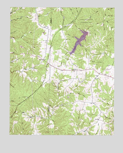
Ovilla, TN USGS Topographic Map
Click on map above to begin viewing in our Map Viewer.

This topographic map contains these locations and features:
Feature Name Type Latitude Longitude GNIS ID View Map
Bird (historical)Populated PlaceN35.3390°W87.5806°1302706View Map
Buck BranchStreamN35.2520°W87.5434°1278788View Map
Canaan Freewill Baptist ChurchChurchN35.2687°W87.5759°1641969View Map
Commissioner District 13CivilN35.2871°W87.5058°2464325View Map
County Line Church (historical)ChurchN35.3092°W87.5775°1302725View Map
County Line School (historical)SchoolN35.3142°W87.5722°1302990View Map
Dock HollowValleyN35.3397°W87.5423°1282543View Map
Dog CreekStreamN35.3445°W87.6122°1282587View Map
Dogwood MudholeLocaleN35.2712°W87.6109°1282613View Map
Duckworth BranchStreamN35.2926°W87.5492°1283054View Map
Field Pond BranchStreamN35.2501°W87.5284°1284236View Map
Fishtrap CemeteryCemeteryN35.2687°W87.5764°1641985View Map
Fishtrap School (historical)SchoolN35.2687°W87.5759°1303002View Map
Galloway BranchStreamN35.3459°W87.5478°1285104View Map
Gower (historical)Populated PlaceN35.3209°W87.5806°1302780View Map
Gravel Hill CemeteryCemeteryN35.3003°W87.5742°1285930View Map
Grews BranchStreamN35.2767°W87.5734°1286252View Map
Ham BranchStreamN35.3617°W87.5136°1286617View Map
HighlandPopulated PlaceN35.3237°W87.5856°1287729View Map
Highland CemeteryCemeteryN35.3231°W87.5856°1641815View Map
Highland Methodist ChurchChurchN35.3234°W87.5859°1641816View Map
Highland School (historical)SchoolN35.3229°W87.5861°1302755View Map
Laurel Hill LakeReservoirN35.3426°W87.5416°1290753View Map
Laurel Hill Lake DamDamN35.3509°W87.5331°1307106View Map
Laurel Hill Wildlife Management AreaParkN35.3640°W87.5195°1290754View Map
Mine BranchStreamN35.3665°W87.5089°1294026View Map
New HavenPopulated PlaceN35.3140°W87.5445°1646971View Map
New Haven ChurchChurchN35.3140°W87.5467°1295490View Map
OvillaPopulated PlaceN35.3134°W87.5611°1296554View Map
Ovilla Lookout TowerTowerN35.2867°W87.6036°1647786View Map
Ovilla Volunteer Fire DepartmentBuildingN35.3183°W87.5770°2653681View Map
Owl HollowValleyN35.2785°W87.5025°1296596View Map
Owl Hollow CemeteryCemeteryN35.2845°W87.5142°1296609View Map
Peter Cave CreekStreamN35.3629°W87.5114°1297243View Map
Piney SchoolSchoolN35.2654°W87.5192°1297652View Map
Poag BranchStreamN35.3565°W87.5275°1297990View Map
Ray BranchStreamN35.2773°W87.5731°1298984View Map
Reed BranchStreamN35.3479°W87.5022°1299118View Map
Short BranchStreamN35.3742°W87.5092°1270179View Map
Spann CemeteryCemeteryN35.3140°W87.5456°1270949View Map
Staggs BranchStreamN35.2876°W87.5664°1303784View Map
Staggs CemeteryCemeteryN35.3362°W87.5917°1641909View Map
Suckstem BranchStreamN35.2648°W87.5750°1303889View Map
Taylor BranchStreamN35.2781°W87.5014°1272188View Map
Unity CemeteryCemeteryN35.2776°W87.5203°1642034View Map
Unity Church of GodChurchN35.2779°W87.5206°1642035View Map
Voorhies BranchStreamN35.3529°W87.5411°1273496View Map
Weaver BranchStreamN35.3554°W87.5042°1273987View Map
West End Volunteer Fire DepartmentBuildingN35.3106°W87.5175°2653607View Map

Note: Coordinates in the location and feature list above are referenced to NAD83 datum.


Copyright (C) 2008-2024 Ryan Niemi / Sunset Dynamics ... All Rights Reserved