TopoQuest Logo
Do you find TopoQuest useful?
Help keep TopoQuest running and adding new maps/features by donating!
Bitcoin:  19c7KJd3qBynnjoSw5npx9KScwjBe4ifkT
Litecoin:  LXs6TkuXGGXo1vDsWCkWVdjQX94eUKd6ui
Home View Maps Find Maps Find Places Resources & Links


Longwood, Missouri Topographic Map

USGS Map Title: Longwood, MO
USGS Map MRC: 38093H2
DRG (GeoTIFF) Download: o38093h2.tif


Neighboring USGS Topographic Map Quads:


  Shackleford, MO  
39093A3
 

  Marshall South, MO  
39093A2
 

  Napton, MO  
39093A1
 

  Houstonia, MO  
38093H3
 

  Longwood, MO  
38093H2
 

  Nelson, MO  
38093H1
 

  Hughesville, MO  
38093G3
 

  Beaman, MO  
38093G2
 

  Clifton City, MO  
38093G1


Map MRC Location:

N39°
W94°
N39°
W93°
H8 H7 H6 H5 H4 H3 H2 H1
G8 G7 G6 G5 G4 G3 G2 G1
F8 F7 F6 F5 F4 F3 F2 F1
E8 E7 E6 E5 E4 E3 E2 E1
D8 D7 D6 D5 D4 D3 D2 D1
C8 C7 C6 C5 C4 C3 C2 C1
B8 B7 B6 B5 B4 B3 B2 B1
A8 A7 A6 A5 A4 A3 A2 A1
N38°
W94°
N38°
W93°

Longwood, MO USGS 1:24K Topographic Map Preview:
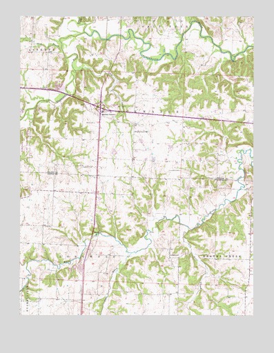
Longwood, MO USGS Topographic Map
Click on map above to begin viewing in our Map Viewer.

This topographic map contains these locations and features:
Feature Name Type Latitude Longitude GNIS ID View Map
Anderson School (historical)SchoolN38.9089°W93.1263°745404View Map
Bethlehem CemeteryCemeteryN38.9370°W93.2174°714088View Map
Buck BranchStreamN38.9867°W93.2283°714952View Map
Cunningham CemeteryCemeteryN38.9356°W93.1646°716593View Map
Dry CreekStreamN38.9772°W93.2205°717085View Map
Elk Hill School (historical)SchoolN38.9756°W93.1333°743567View Map
Finney CreekStreamN38.9934°W93.2158°717928View Map
Forest Grove School (historical)SchoolN38.9492°W93.2280°743569View Map
Greer BranchStreamN38.9009°W93.1908°718853View Map
Long Grove BranchStreamN38.9106°W93.1588°721542View Map
LongwoodPopulated PlaceN38.8992°W93.1699°729770View Map
Longwood CemeteryCemeteryN38.8966°W93.1682°2702638View Map
Marshall JunctionPopulated PlaceN38.9581°W93.2066°729337View Map
Oak Grove School (historical)SchoolN38.8995°W93.2019°745403View Map
Pettis County Fire District 1 Station 3BuildingN38.9008°W93.1697°2621281View Map
Pipertown (historical)Populated PlaceN38.9603°W93.1294°740033View Map
Pleasant Valley School (historical)SchoolN38.9892°W93.2438°743590View Map
Prairie Lawn School (historical)SchoolN38.9520°W93.1891°724872View Map
Prairie Ridge School (historical)SchoolN38.9125°W93.2455°745402View Map
Township of BlackwaterCivilN38.9622°W93.1409°767358View Map
Township of LongwoodCivilN38.8779°W93.2084°767171View Map
Wanamaker (historical)Populated PlaceN38.9403°W93.1899°738658View Map
Witcher CemeteryCemeteryN38.9553°W93.2105°729021View Map
Woodson (historical)LocaleN38.9722°W93.2172°740450View Map
Woodson School (historical)SchoolN38.9800°W93.1938°743613View Map

Note: Coordinates in the location and feature list above are referenced to NAD83 datum.


Copyright (C) 2008-2025 Ryan Niemi / Sunset Dynamics ... All Rights Reserved