TopoQuest Logo
Do you find TopoQuest useful?
Help keep TopoQuest running and adding new maps/features by donating!
Bitcoin:  19c7KJd3qBynnjoSw5npx9KScwjBe4ifkT
Litecoin:  LXs6TkuXGGXo1vDsWCkWVdjQX94eUKd6ui
Home View Maps Find Maps Find Places Resources & Links


Lovingston, Virginia Topographic Map

USGS Map Title: Lovingston, VA
USGS Map MRC: 37078G7
DRG (GeoTIFF) Download: o37078g7.tif


Neighboring USGS Topographic Map Quads:


  Sherando, VA  
37078H8
 

  Greenfield, VA  
37078H7
 

  Covesville, VA  
37078H6
 

  Horseshoe Mountain, VA  
37078G8
 

  Lovingston, VA  
37078G7
 

  Schuyler, VA  
37078G6
 

  Arrington, VA  
37078F8
 

  Shipman, VA  
37078F7
 

  Howardsville, VA  
37078F6


Map MRC Location:

N38°
W79°
N38°
W78°
H8 H7 H6 H5 H4 H3 H2 H1
G8 G7 G6 G5 G4 G3 G2 G1
F8 F7 F6 F5 F4 F3 F2 F1
E8 E7 E6 E5 E4 E3 E2 E1
D8 D7 D6 D5 D4 D3 D2 D1
C8 C7 C6 C5 C4 C3 C2 C1
B8 B7 B6 B5 B4 B3 B2 B1
A8 A7 A6 A5 A4 A3 A2 A1
N37°
W79°
N37°
W78°

Lovingston, VA USGS 1:24K Topographic Map Preview:
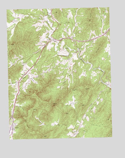
Lovingston, VA USGS Topographic Map
Click on map above to begin viewing in our Map Viewer.

This topographic map contains these locations and features:
Feature Name Type Latitude Longitude GNIS ID View Map
AdialPopulated PlaceN37.8649°W78.8303°1495183View Map
Adial CemeteryCemeteryN37.8659°W78.8336°1500918View Map
Adial ChurchChurchN37.8663°W78.8345°1462369View Map
Bailey MountainSummitN37.7801°W78.7864°1462684View Map
Ball MountainSummitN37.7665°W78.7528°1462734View Map
Bernard Hamilton DamDamN37.8668°W78.8597°1490438View Map
Buck CreekStreamN37.8363°W78.7892°1482108View Map
Cedar Grove CemeteryCemeteryN37.8428°W78.7727°1500922View Map
Cedar Grove ChurchChurchN37.8432°W78.7736°1464618View Map
Cedar Grove School (historical)SchoolN37.8435°W78.7731°1500923View Map
Central DistrictCivilN37.8693°W78.8527°2631323View Map
Cove CreekStreamN37.7993°W78.7525°1465327View Map
Craig CreekStreamN37.8132°W78.8509°1465398View Map
Cub CreekStreamN37.8501°W78.7559°1465510View Map
Davis CreekStreamN37.8451°W78.8189°1482944View Map
Davis Creek School (historical)SchoolN37.8201°W78.8709°1500924View Map
Diggs MountainSummitN37.8615°W78.7736°1465793View Map
Dutch Creek School (historical)SchoolN37.7632°W78.8295°1500925View Map
East DistrictCivilN37.7544°W78.7754°2631324View Map
Ebenezer ChurchChurchN37.7560°W78.7822°1466150View Map
Edes HollowValleyN37.7831°W78.8673°1466171View Map
ElmaPopulated PlaceN37.7538°W78.7950°1477304View Map
Elmington ChurchChurchN37.7554°W78.7956°1466259View Map
GullysvillePopulated PlaceN37.8632°W78.8678°1495632View Map
Hamilton LakeReservoirN37.8668°W78.8609°1490439View Map
Harris CoveValleyN37.7828°W78.7968°1467776View Map
Hills MountainSummitN37.8715°W78.8128°1484119View Map
Lawthorne MillPopulated PlaceN37.8276°W78.7875°1495830View Map
LovingstonPopulated PlaceN37.7599°W78.8709°1498508View Map
Lovingston Census Designated PlaceCensusN37.7605°W78.8689°2584869View Map
Lovingston Post OfficePost OfficeN37.7600°W78.8712°2766386View Map
Lovingston Volunteer Fire DepartmentBuildingN37.7613°W78.8740°2086126View Map
Melton HollowValleyN37.7820°W78.8596°1500933View Map
Mosby MountainSummitN37.7729°W78.8061°1470772View Map
Mount Zion Church (historical)ChurchN37.8388°W78.8292°1500935View Map
Muddy CreekStreamN37.8404°W78.8270°1485739View Map
MyndusLocaleN37.8121°W78.8547°1471299View Map
Naked MountainSummitN37.7526°W78.8334°1495988View Map
Nelson County CourthouseBuildingN37.7599°W78.8692°1500937View Map
Nelson County Sheriff OfficeBuildingN37.7599°W78.8692°2086130View Map
Oak Hill ChurchChurchN37.8213°W78.8550°1471755View Map
Old MyndusPopulated PlaceN37.8215°W78.8547°1500943View Map
Peebles MountainSummitN37.7601°W78.8525°1472172View Map
Perkins HollowValleyN37.8622°W78.7578°1486144View Map
Polly Wright CoveValleyN37.8046°W78.8626°1486319View Map
Poplar School (historical)SchoolN37.8674°W78.8017°1500947View Map
Ridgecrest Baptist ChurchChurchN37.8288°W78.8356°1500949View Map
Ridgecrest CemeteryCemeteryN37.8297°W78.8349°1500950View Map
Roberts MountainSummitN37.8413°W78.8667°1473318View Map
Rock Spring MountainSummitN37.8393°W78.7611°1473394View Map
RockfishPopulated PlaceN37.8013°W78.7556°1496163View Map
Schuyler District (historical)CivilN37.8035°W78.7672°1927489View Map
Simpson HollowValleyN37.8076°W78.8496°1474615View Map
Simpson MountainSummitN37.7774°W78.8459°1474616View Map
Stage BridgeBridgeN37.8360°W78.7884°1475051View Map
Sugarloaf MountainSummitN37.7824°W78.8206°1475297View Map
The HorseshoeSummitN37.8379°W78.8036°1496305View Map
Thoroughfare GapGapN37.7960°W78.7959°1475685View Map
Twin PoplarsPopulated PlaceN37.8607°W78.8039°1496337View Map
Union Springs School (historical)SchoolN37.7563°W78.7822°1500955View Map
Walnut Grove Church (historical)ChurchN37.8160°W78.8350°1500956View Map
Wheeler CoveValleyN37.8115°W78.7972°1476553View Map
Willoughby MountainSummitN37.7957°W78.7814°1476790View Map
Woodridge FieldAirportN37.8388°W78.8210°2675600View Map
Woods MillPopulated PlaceN37.8449°W78.8222°1496439View Map

Note: Coordinates in the location and feature list above are referenced to NAD83 datum.


Copyright (C) 2008-2025 Ryan Niemi / Sunset Dynamics ... All Rights Reserved