TopoQuest Logo
Do you find TopoQuest useful?
Help keep TopoQuest running and adding new maps/features by donating!
Bitcoin:  19c7KJd3qBynnjoSw5npx9KScwjBe4ifkT
Litecoin:  LXs6TkuXGGXo1vDsWCkWVdjQX94eUKd6ui
Home View Maps Find Maps Find Places Resources & Links


Lurton, Arkansas Topographic Map

USGS Map Title: Lurton, AR
USGS Map MRC: 35093G1
DRG (GeoTIFF) Download: o35093g1.tif


Neighboring USGS Topographic Map Quads:


  Parthenon, AR  
35093H2
 

  Mount Judea, AR  
35093H1
 

  Eula, AR  
35092H8
 

  Deer, AR  
35093G2
 

  Lurton, AR  
35093G1
 

  Moore, AR  
35092G8
 

  Fort Douglas, AR  
35093F2
 

  Sand Gap, AR  
35093F1
 

  Smyrna, AR  
35092F8


Map MRC Location:

N36°
W94°
N36°
W93°
H8 H7 H6 H5 H4 H3 H2 H1
G8 G7 G6 G5 G4 G3 G2 G1
F8 F7 F6 F5 F4 F3 F2 F1
E8 E7 E6 E5 E4 E3 E2 E1
D8 D7 D6 D5 D4 D3 D2 D1
C8 C7 C6 C5 C4 C3 C2 C1
B8 B7 B6 B5 B4 B3 B2 B1
A8 A7 A6 A5 A4 A3 A2 A1
N35°
W94°
N35°
W93°

Lurton, AR USGS 1:24K Topographic Map Preview:
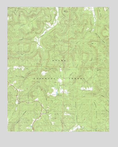
Lurton, AR USGS Topographic Map
Click on map above to begin viewing in our Map Viewer.

This topographic map contains these locations and features:
Feature Name Type Latitude Longitude GNIS ID View Map
Battle CreekStreamN35.8162°W93.0830°59371View Map
Campbell CreekStreamN35.8415°W93.0874°70976View Map
Cow CreekStreamN35.8370°W93.0874°71260View Map
Cox HollowValleyN35.7517°W93.0518°74535View Map
Dan Heffley BranchStreamN35.8104°W93.0871°59370View Map
Daniel MountainSummitN35.8384°W93.0182°59378View Map
Falls BranchStreamN35.8409°W93.0355°71586View Map
George MountainRangeN35.8576°W93.0432°71746View Map
Greenhaw HollowValleyN35.7576°W93.0398°59374View Map
Greenhaw MountainSummitN35.7729°W93.0160°71838View Map
Hamilton SchoolSchoolN35.8431°W93.0880°71888View Map
Holt (historical)Populated PlaceN35.8404°W93.0877°69922View Map
Hudson MountainSummitN35.8592°W93.1016°72109View Map
Ketcherside Fire TowerTowerN35.8095°W93.0157°82464View Map
Ketcherside MountainSummitN35.8112°W93.0160°59376View Map
LurtonPopulated PlaceN35.7715°W93.0777°72519View Map
Lurton - Pelsor Volunteer Fire DepartmentBuildingN35.7716°W93.0773°2116746View Map
Macedonia SchoolSchoolN35.8534°W93.1149°72530View Map
Middle MountainSummitN35.8656°W93.0105°59379View Map
Rock House HollowValleyN35.8510°W93.0197°59380View Map
Sams ThroneCliffN35.8709°W93.0585°73470View Map
Sassafras KnobSummitN35.7787°W93.1136°73483View Map
Shulers PointRidgeN35.8204°W93.0380°59375View Map
Spence JucntionPopulated PlaceN35.7876°W93.0635°59373View Map
Still HollowValleyN35.7520°W93.0162°59124View Map
Tarlton CemeteryCemeteryN35.7870°W93.0660°59372View Map
Tarlton FlatsFlatN35.8017°W93.0557°73823View Map
Tilly CreekStreamN35.7987°W93.0855°59369View Map
Township of Big CreekCivilN35.8685°W93.0877°69672View Map
Township of RichlandCivilN35.7713°W93.0926°69692View Map

Note: Coordinates in the location and feature list above are referenced to NAD83 datum.


Copyright (C) 2008-2024 Ryan Niemi / Sunset Dynamics ... All Rights Reserved