TopoQuest Logo
Do you find TopoQuest useful?
Help keep TopoQuest running and adding new maps/features by donating!
Bitcoin:  19c7KJd3qBynnjoSw5npx9KScwjBe4ifkT
Litecoin:  LXs6TkuXGGXo1vDsWCkWVdjQX94eUKd6ui
Home View Maps Find Maps Find Places Resources & Links


Lyons, Oregon Topographic Map

USGS Map Title: Lyons, OR
USGS Map MRC: 44122G5
DRG (GeoTIFF) Download: o44122g5.tif


Neighboring USGS Topographic Map Quads:


  Drake Crossing, OR  
44122H6
 

  Elk Prairie, OR  
44122H5
 

  Gawley Creek, OR  
44122H4
 

  Stout Mountain, OR  
44122G6
 

  Lyons, OR  
44122G5
 

  Mill City North, OR  
44122G4
 

  Jordan, OR  
44122F6
 

  Snow Peak, OR  
44122F5
 

  Mill City South, OR  
44122F4


Map MRC Location:

N45°
W123°
N45°
W122°
H8 H7 H6 H5 H4 H3 H2 H1
G8 G7 G6 G5 G4 G3 G2 G1
F8 F7 F6 F5 F4 F3 F2 F1
E8 E7 E6 E5 E4 E3 E2 E1
D8 D7 D6 D5 D4 D3 D2 D1
C8 C7 C6 C5 C4 C3 C2 C1
B8 B7 B6 B5 B4 B3 B2 B1
A8 A7 A6 A5 A4 A3 A2 A1
N44°
W123°
N44°
W122°

Lyons, OR USGS 1:24K Topographic Map Preview:
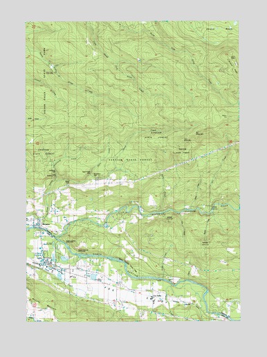
Lyons, OR USGS Topographic Map
Click on map above to begin viewing in our Map Viewer.

This topographic map contains these locations and features:
Feature Name Type Latitude Longitude GNIS ID View Map
Alder CreekStreamN44.7676°W122.5454°1116815View Map
Ayers CreekStreamN44.8112°W122.5887°1117113View Map
Ayers Creek FallsFallsN44.8118°W122.5884°1131500View Map
Beaver CreekStreamN44.7954°W122.5165°1117427View Map
Big Green MountainSummitN44.8287°W122.5268°1117628View Map
Buck Mountain Fire BreakTrailN44.8379°W122.6181°1118206View Map
Buck PointSummitN44.8590°W122.5065°1136099View Map
Cherry CreekStreamN44.7665°W122.5315°1118852View Map
City of LyonsCivilN44.7776°W122.6098°2410902View Map
Cow CreekStreamN44.7646°W122.5395°1131505View Map
Cox CreekStreamN44.7951°W122.5354°1119443View Map
Fawn (historical)LocaleN44.7693°W122.5959°1136281View Map
Fishermen's Bend Bureau of Land Management Boat RampLocaleN44.7533°W122.5144°2700077View Map
Fox ValleyPopulated PlaceN44.7596°W122.5518°1158243View Map
Fox ValleyValleyN44.7804°W122.6126°1158244View Map
Fox Valley CemeteryCemeteryN44.7707°W122.5848°1120945View Map
Fox Valley Post Office (historical)Post OfficeN44.7596°W122.5518°1165276View Map
Freres Log PondsReservoirN44.7696°W122.6048°1637977View Map
Freres LumberLocaleN44.7712°W122.6078°2699379View Map
GoochLocaleN44.7571°W122.5284°1136326View Map
Gooch Post Office (historical)Post OfficeN44.7571°W122.5284°1165326View Map
Horseshoe FallsFallsN44.8102°W122.5866°1132445View Map
Jeeter CreekStreamN44.7971°W122.5248°1122392View Map
John Neal Memorial County ParkParkN44.7821°W122.6101°1966244View Map
John Neal Memorial County Park Boat RampLocaleN44.7830°W122.6063°2700059View Map
Kiel CreekStreamN44.7948°W122.5204°1163087View Map
Little Green MountainSummitN44.8254°W122.5348°1136489View Map
Little North Santiam RiverStreamN44.7862°W122.6101°1145216View Map
Lower Shellburg FallsFallsN44.8102°W122.6083°1131499View Map
LyonsPopulated PlaceN44.7746°W122.6151°1123641View Map
Lyons - Mehama County Park Boat RampLocaleN44.7886°W122.6182°2700076View Map
Lyons City HallBuildingN44.7774°W122.6166°2699562View Map
Lyons Log PondReservoirN44.7693°W122.5873°1637978View Map
Lyons Mehama County ParkParkN44.7882°W122.6187°1966247View Map
Lyons Post OfficePost OfficeN44.7836°W122.6180°1165572View Map
Lyons Public LibraryBuildingN44.7750°W122.6134°2699563View Map
Lyons Rural Fire Protection District Station 1BuildingN44.7730°W122.6109°2576569View Map
Manis CreekStreamN44.7679°W122.5498°1132735View Map
Mari - Linn Elementary SchoolSchoolN44.7793°W122.6168°1123755View Map
McCully MountainSummitN44.7573°W122.6237°1123929View Map
MehamaPopulated PlaceN44.7901°W122.6193°1124044View Map
Mehama Post OfficePost OfficeN44.7901°W122.6193°1165620View Map
Noroma CreekStreamN44.7943°W122.5456°1131502View Map
North Fork County ParkParkN44.7971°W122.5651°1162316View Map
North Santiam State ParkParkN44.7712°W122.5651°1851881View Map
North Santiam State Park Recreation AreaLocaleN44.7730°W122.5674°2699650View Map
Ornoname 7 DamDamN44.7715°W122.6095°1163815View Map
Polly CreekStreamN44.7951°W122.5468°1125548View Map
Rocky TopSummitN44.8348°W122.5034°1126251View Map
Santiam Valley GrangeBuildingN44.7848°W122.6165°1126601View Map
Shellburg CreekStreamN44.8085°W122.6087°1126861View Map
Shellburg FallsFallsN44.8126°W122.6086°1126862View Map
South Silver Creek Youth CampLocaleN44.8548°W122.6098°1127348View Map
Stasel FallsFallsN44.8087°W122.6006°1127544View Map
Stout Creek FallsFallsN44.8139°W122.5739°1131501View Map
Taylor GroveWoodsN44.7873°W122.5756°1127904View Map
Walker CreekStreamN44.7901°W122.5165°1131503View Map
Weatbery (historical)LocaleN44.7748°W122.6198°1166416View Map

Note: Coordinates in the location and feature list above are referenced to NAD83 datum.


Copyright (C) 2008-2025 Ryan Niemi / Sunset Dynamics ... All Rights Reserved