TopoQuest Logo
Do you find TopoQuest useful?
Help keep TopoQuest running and adding new maps/features by donating!
Bitcoin:  19c7KJd3qBynnjoSw5npx9KScwjBe4ifkT
Litecoin:  LXs6TkuXGGXo1vDsWCkWVdjQX94eUKd6ui
Home View Maps Find Maps Find Places Resources & Links


Elk Prairie, Oregon Topographic Map

USGS Map Title: Elk Prairie, OR
USGS Map MRC: 44122H5
DRG (GeoTIFF) Download: o44122h5.tif


Neighboring USGS Topographic Map Quads:


  Scotts Mills, OR  
45122A6
 

  Wilhoit, OR  
45122A5
 

  Fernwood, OR  
45122A4
 

  Drake Crossing, OR  
44122H6
 

  Elk Prairie, OR  
44122H5
 

  Gawley Creek, OR  
44122H4
 

  Stout Mountain, OR  
44122G6
 

  Lyons, OR  
44122G5
 

  Mill City North, OR  
44122G4


Map MRC Location:

N45°
W123°
N45°
W122°
H8 H7 H6 H5 H4 H3 H2 H1
G8 G7 G6 G5 G4 G3 G2 G1
F8 F7 F6 F5 F4 F3 F2 F1
E8 E7 E6 E5 E4 E3 E2 E1
D8 D7 D6 D5 D4 D3 D2 D1
C8 C7 C6 C5 C4 C3 C2 C1
B8 B7 B6 B5 B4 B3 B2 B1
A8 A7 A6 A5 A4 A3 A2 A1
N44°
W123°
N44°
W122°

Elk Prairie, OR USGS 1:24K Topographic Map Preview:
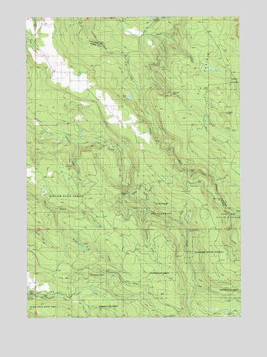
Elk Prairie, OR USGS Topographic Map
Click on map above to begin viewing in our Map Viewer.

This topographic map contains these locations and features:
Feature Name Type Latitude Longitude GNIS ID View Map
Abiqua BasinBasinN44.8851°W122.5270°1162804View Map
Abiqua Creek ParkParkN44.9568°W122.6234°1162313View Map
Abiqua FallsFallsN44.9263°W122.5673°1162805View Map
Abiqua LakeLakeN44.8792°W122.5054°1131498View Map
Betty Jane Deardorff DamDamN44.9998°W122.5479°1133458View Map
Bridge CreekStreamN44.9187°W122.6087°1118068View Map
Bridge Creek Post Office (historical)Post OfficeN44.8971°W122.5706°1164953View Map
Bucket CreekStreamN44.9137°W122.5373°1131495View Map
Butte Creek FallsFallsN44.9235°W122.5123°1131493View Map
Camp PetersonLocaleN44.9332°W122.5873°1162314View Map
Cedar Camp Post Office (historical)Post OfficeN44.8943°W122.5720°1164259View Map
Cedar CreekStreamN44.9485°W122.5984°1131492View Map
Crooked Finger PrairieFlatN44.9790°W122.6081°1952915View Map
Crooked Finger School (historical)SchoolN44.9782°W122.6098°1119570View Map
Elk PrairieFlatN44.9737°W122.5243°1120462View Map
Elk Prairie School (historical)SchoolN44.9690°W122.5195°1120463View Map
Fall CreekStreamN44.9698°W122.5587°1120609View Map
Fall Creek FallsFallsN44.9672°W122.5396°1120611View Map
Goober CreekStreamN44.9221°W122.5609°1163595View Map
Holy Rosary CemeteryCemeteryN44.9993°W122.6226°1135163View Map
Holy Rosary ChurchChurchN44.9943°W122.6168°1121937View Map
Homestead CreekStreamN44.9201°W122.5554°1135496View Map
Johnston CreekStreamN44.9207°W122.5595°1131494View Map
Kautz MansionBuildingN44.9621°W122.5173°1119360View Map
Kirk CreekStreamN44.9190°W122.5062°1122780View Map
Little Coal CreekStreamN44.9929°W122.5623°1132738View Map
Little North Fork Silver CreekStreamN44.8840°W122.5981°1123243View Map
Looney CreekStreamN44.9290°W122.5151°1131487View Map
Marion CountyCivilN44.9033°W122.5849°1135859View Map
Meyers ButteSummitN44.9582°W122.5068°1131486View Map
Middle Fork Cedar CreekStreamN44.9318°W122.5956°1131489View Map
Moss LakeLakeN44.9735°W122.5790°1163594View Map
North FallsFallsN44.8850°W122.6240°1135497View Map
North Fork Cedar CreekStreamN44.9318°W122.5956°1131490View Map
Priest CreekStreamN44.9332°W122.5970°1131491View Map
Silverton Fire District Station 9 Scotts MillsBuildingN44.9929°W122.6208°2577033View Map
South Fork Cedar CreekStreamN44.9485°W122.5956°1131488View Map
South Forks Falls CreekStreamN44.9582°W122.5206°1131504View Map
Trinity Falls CreekStreamN44.9096°W122.5331°1131496View Map
Upper North FallsFallsN44.8832°W122.6142°1163596View Map

Note: Coordinates in the location and feature list above are referenced to NAD83 datum.


Copyright (C) 2008-2025 Ryan Niemi / Sunset Dynamics ... All Rights Reserved