TopoQuest Logo
Do you find TopoQuest useful?
Help keep TopoQuest running and adding new maps/features by donating!
Bitcoin:  19c7KJd3qBynnjoSw5npx9KScwjBe4ifkT
Litecoin:  LXs6TkuXGGXo1vDsWCkWVdjQX94eUKd6ui
Home View Maps Find Maps Find Places Resources & Links


Manchester, Wisconsin Topographic Map

USGS Map Title: Manchester, WI
USGS Map MRC: 43089F1
DRG (GeoTIFF) Download: o43089f1.tif


Neighboring USGS Topographic Map Quads:


  Princeton West, WI  
43089G2
 

  Princeton East, WI  
43089G1
 

  Green Lake, WI  
43088G8
 

  Marquette, WI  
43089F2
 

  Manchester, WI  
43089F1
 

  Markesan, WI  
43088F8
 

  Sand Spring Creek, WI  
43089E2
 

  Randolph, WI  
43089E1
 

  Fox Lake, WI  
43088E8


Map MRC Location:

N44°
W90°
N44°
W89°
H8 H7 H6 H5 H4 H3 H2 H1
G8 G7 G6 G5 G4 G3 G2 G1
F8 F7 F6 F5 F4 F3 F2 F1
E8 E7 E6 E5 E4 E3 E2 E1
D8 D7 D6 D5 D4 D3 D2 D1
C8 C7 C6 C5 C4 C3 C2 C1
B8 B7 B6 B5 B4 B3 B2 B1
A8 A7 A6 A5 A4 A3 A2 A1
N43°
W90°
N43°
W89°

Manchester, WI USGS 1:24K Topographic Map Preview:
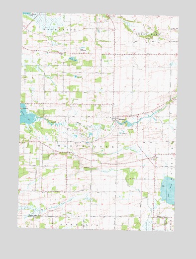
Manchester, WI USGS Topographic Map
Click on map above to begin viewing in our Map Viewer.

This topographic map contains these locations and features:
Feature Name Type Latitude Longitude GNIS ID View Map
Carter SchoolSchoolN43.6553°W89.0212°1562750View Map
Dantz Tavern SchoolSchoolN43.7500°W89.0515°1563708View Map
Dog LakeLakeN43.7134°W89.0815°1564034View Map
Faith ChurchChurchN43.6850°W89.0323°1843730View Map
Faith Lutheran SchoolSchoolN43.6849°W89.0325°2716469View Map
Grand LakeReservoirN43.6894°W89.1219°1565711View Map
Heart LakeLakeN43.7235°W89.0840°1566246View Map
Hilltop Landing Strip (historical)AirportN43.7291°W89.0784°1843750View Map
Krastetter CemeteryCemeteryN43.6319°W89.0971°1843753View Map
Lake MariaLakeN43.6475°W89.0016°1569030View Map
Lake Maria CemeteryCemeteryN43.6666°W89.0157°1567741View Map
ManchesterPopulated PlaceN43.6905°W89.0484°1568932View Map
Manchester Dam (historical)DamN43.6900°W89.0484°1791924View Map
Manchester Millpond 72 (historical)ReservoirN43.6900°W89.0484°1791925View Map
Military Road SchoolSchoolN43.6741°W89.1071°1569462View Map
Mill Pond (historical)ReservoirN43.6874°W89.0416°1569493View Map
Nowatzski FieldAirportN43.6977°W89.0034°1582064View Map
Oak Grove SchoolSchoolN43.6641°W89.0601°1570626View Map
Phelps CemeteryCemeteryN43.7283°W89.0251°1571290View Map
Saint Johns ChurchChurchN43.6469°W89.0959°1573088View Map
Salemville SchoolSchoolN43.6464°W89.1021°1573633View Map
Town of ManchesterCivilN43.6752°W89.0649°1583633View Map
West Manchester SchoolSchoolN43.7044°W89.1007°1576534View Map
Williams CemeteryCemeteryN43.6611°W89.0673°1576764View Map

Note: Coordinates in the location and feature list above are referenced to NAD83 datum.


Copyright (C) 2008-2025 Ryan Niemi / Sunset Dynamics ... All Rights Reserved