TopoQuest Logo
Do you find TopoQuest useful?
Help keep TopoQuest running and adding new maps/features by donating!
Bitcoin:  19c7KJd3qBynnjoSw5npx9KScwjBe4ifkT
Litecoin:  LXs6TkuXGGXo1vDsWCkWVdjQX94eUKd6ui
Home View Maps Find Maps Find Places Resources & Links


Winnsboro, Louisiana Topographic Map

USGS Map Title: Winnsboro, LA
USGS Map MRC: 32091B6
DRG (GeoTIFF) Download: o32091b6.tif


Neighboring USGS Topographic Map Quads:


  Mangham, LA  
32091C7
 

  Baskinton, LA  
32091C6
 

  Lamar, LA  
32091C5
 

  Liddieville, LA  
32091B7
 

  Winnsboro, LA  
32091B6
 

  Crowville, LA  
32091B5
 

  Fort Necessity, LA  
32091A7
 

  Gilbert, LA  
32091A6
 

  Como, LA  
32091A5


Map MRC Location:

N33°
W92°
N33°
W91°
H8 H7 H6 H5 H4 H3 H2 H1
G8 G7 G6 G5 G4 G3 G2 G1
F8 F7 F6 F5 F4 F3 F2 F1
E8 E7 E6 E5 E4 E3 E2 E1
D8 D7 D6 D5 D4 D3 D2 D1
C8 C7 C6 C5 C4 C3 C2 C1
B8 B7 B6 B5 B4 B3 B2 B1
A8 A7 A6 A5 A4 A3 A2 A1
N32°
W92°
N32°
W91°

Winnsboro, LA USGS 1:24K Topographic Map Preview:
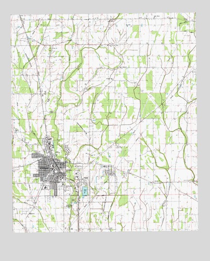
Winnsboro, LA USGS Topographic Map
Click on map above to begin viewing in our Map Viewer.

This topographic map contains these locations and features:
Feature Name Type Latitude Longitude GNIS ID View Map
Ash SloughGutN32.1502°W91.7321°532229View Map
Bell Union ChurchChurchN32.2318°W91.6826°532918View Map
Church of Christ (historical)ChurchN32.2474°W91.6551°541669View Map
City of WinnsboroCivilN32.1650°W91.7210°2405768View Map
Civitan ParkParkN32.1546°W91.7110°544569View Map
Coax CemeteryCemeteryN32.2310°W91.7223°544077View Map
Coax ChurchChurchN32.2302°W91.7232°534012View Map
Davis ParkParkN32.1513°W91.7040°544571View Map
Faith TabernacleChurchN32.2190°W91.6782°541668View Map
First Baptist ChurchChurchN32.1624°W91.7173°544572View Map
First Church of the NazareneChurchN32.1738°W91.7273°544574View Map
First United Methodist ChurchChurchN32.1640°W91.7160°544575View Map
First Zion Baptist ChurchChurchN32.1571°W91.7196°544576View Map
Fletcher Landing StripAirportN32.2449°W91.6810°544083View Map
Franklin Academy SchoolSchoolN32.1563°W91.7063°544087View Map
Franklin Medical CenterHospitalN32.1588°W91.7067°544578View Map
Franklin ParishCivilN32.1332°W91.6738°558557View Map
Franklin Parish CourthouseBuildingN32.1657°W91.7137°544577View Map
Franklin Parish High SchoolSchoolN32.1515°W91.7277°544106View Map
Franklin Parish Public LibraryBuildingN32.1649°W91.7143°544088View Map
Franklin Parish Sheriff's OfficeBuildingN32.1657°W91.7137°2755352View Map
Freedom Bible ChurchChurchN32.2115°W91.6821°554477View Map
Horace G White Sr Learning Center SchoolSchoolN32.1628°W91.6877°554474View Map
Jackson Street Historic DistrictParkN32.1660°W91.7132°544579View Map
Jesus Name Home Mission ChurchChurchN32.1565°W91.7193°544581View Map
Kingdom HallChurchN32.1829°W91.7476°541665View Map
Landis Memorial ParkParkN32.1699°W91.7210°541664View Map
Louisiana Noname 92 DamDamN32.1468°W91.6985°556964View Map
Louisiana Technical College Northeast CampusSchoolN32.1617°W91.7208°544584View Map
Macon Ridge Agricultural Experiment StationLocaleN32.1404°W91.7096°541355View Map
Myrtle Memorial CemeteryCemeteryN32.1501°W91.7148°541354View Map
New Winnsboro CemeteryCemeteryN32.1515°W91.7148°541353View Map
Old Winnsboro CemeteryCemeteryN32.1610°W91.7148°541352View Map
Open SloughGutN32.2390°W91.6321°537887View Map
Parish Governing Authority District 5CivilN32.1509°W91.6921°1930077View Map
Pine Grove CemeteryCemeteryN32.2068°W91.7001°541667View Map
Saint John Baptist ChurchChurchN32.1585°W91.7290°544585View Map
Saint Marys Catholic ChurchChurchN32.1607°W91.7160°544586View Map
Second Baptist ChurchChurchN32.1671°W91.7257°544587View Map
Shiloh Baptist ChurchChurchN32.1613°W91.7307°544588View Map
Taylor Bayou ChurchChurchN32.2474°W91.6537°539796View Map
Temple Baptist ChurchChurchN32.1671°W91.7307°544589View Map
Town Square ParkParkN32.1649°W91.7207°544590View Map
True Light Baptist ChurchChurchN32.1660°W91.7279°544591View Map
True Light CemeteryCemeteryN32.1679°W91.6976°539999View Map
True Light ChurchChurchN32.1649°W91.7073°540002View Map
True Light Church Gas FieldOilfieldN32.1779°W91.7068°544102View Map
Twin Oaks County ClubLocaleN32.1746°W91.6793°541666View Map
Ward SevenCivilN32.1579°W91.7276°545032View Map
Wayside CemeteryCemeteryN32.1526°W91.6557°544104View Map
Wayside ChurchChurchN32.1529°W91.6543°556378View Map
West Winnsboro Recreational ParkParkN32.1560°W91.7285°544592View Map
Wildcat StadiumParkN32.1510°W91.7260°544593View Map
WinnsboroPopulated PlaceN32.1632°W91.7207°1630025View Map
Winnsboro Assembly of God ChurchChurchN32.1690°W91.7351°544594View Map
Winnsboro City HallBuildingN32.1646°W91.7212°544595View Map
Winnsboro Commercial Historic DistrictParkN32.1646°W91.7187°544596View Map
Winnsboro Fire DepartmentBuildingN32.1646°W91.7215°2672962View Map
Winnsboro Industrial parkLocaleN32.1985°W91.7268°544597View Map
Winnsboro Lower Elementary SchoolSchoolN32.1635°W91.7225°544107View Map
Winnsboro Municipal AirportAirportN32.1554°W91.6986°1633012View Map
Winnsboro Pentecostal ChurchChurchN32.1535°W91.7057°544598View Map
Winnsboro Police DepartmentBuildingN32.1674°W91.7215°544599View Map
Winnsboro Post OfficePost OfficeN32.1621°W91.7198°1630066View Map
Winnsboro Upper Elementary SchoolSchoolN32.1643°W91.7223°544108View Map

Note: Coordinates in the location and feature list above are referenced to NAD83 datum.


Copyright (C) 2008-2024 Ryan Niemi / Sunset Dynamics ... All Rights Reserved