TopoQuest Logo
Do you find TopoQuest useful?
Help keep TopoQuest running and adding new maps/features by donating!
Bitcoin:  19c7KJd3qBynnjoSw5npx9KScwjBe4ifkT
Litecoin:  LXs6TkuXGGXo1vDsWCkWVdjQX94eUKd6ui
Home View Maps Find Maps Find Places Resources & Links


Marion West, North Carolina Topographic Map

USGS Map Title: Marion West, NC
USGS Map MRC: 35082F1
DRG (GeoTIFF) Download: o35082f1.tif


Neighboring USGS Topographic Map Quads:


  Celo, NC  
35082G2
 

  Little Switzerland, NC  
35082G1
 

  Ashford, NC  
35081G8
 

  Old Fort, NC  
35082F2
 

  Marion West, NC  
35082F1
 

  Marion East, NC  
35081F8
 

  Moffitt Hill, NC  
35082E2
 

  Sugar Hill, NC  
35082E1
 

  Glenwood, NC  
35081E8


Map MRC Location:

N36°
W83°
N36°
W82°
H8 H7 H6 H5 H4 H3 H2 H1
G8 G7 G6 G5 G4 G3 G2 G1
F8 F7 F6 F5 F4 F3 F2 F1
E8 E7 E6 E5 E4 E3 E2 E1
D8 D7 D6 D5 D4 D3 D2 D1
C8 C7 C6 C5 C4 C3 C2 C1
B8 B7 B6 B5 B4 B3 B2 B1
A8 A7 A6 A5 A4 A3 A2 A1
N35°
W83°
N35°
W82°

Marion West, NC USGS 1:24K Topographic Map Preview:
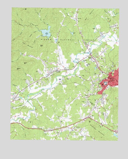
Marion West, NC USGS Topographic Map
Click on map above to begin viewing in our Map Viewer.

This topographic map contains these locations and features:
Feature Name Type Latitude Longitude GNIS ID View Map
Ashworth Road ChurchChurchN35.6507°W82.0165°1024544View Map
Bald MountainSummitN35.7393°W82.0379°1018929View Map
Barnes CemeteryCemeteryN35.7404°W82.0137°1008931View Map
Beatty BranchStreamN35.6762°W82.0784°1009066View Map
Bee BranchStreamN35.7371°W82.0879°1009100View Map
Bethlehem ChurchChurchN35.6690°W82.0184°1024538View Map
Buck CreekStreamN35.6887°W82.0509°1009737View Map
Calvary ChurchChurchN35.7373°W82.0482°1009926View Map
Cane CreekStreamN35.6612°W82.1046°1010003View Map
Carson ChapelChurchN35.7179°W82.0709°1010061View Map
Chestnut BranchStreamN35.7282°W82.0943°1010224View Map
City of MarionCivilN35.6776°W82.0017°2405024View Map
Clear CreekStreamN35.6771°W82.0779°1010314View Map
Clear Creek ChurchChurchN35.6935°W82.0726°1010319View Map
Crooked CreekStreamN35.6443°W82.1098°1023931View Map
Cross Memorial ChurchChurchN35.6760°W82.0226°1024539View Map
Cross Mill ChurchChurchN35.6785°W82.0290°1024540View Map
Deep Cove CreekStreamN35.7057°W82.1134°1010723View Map
East Mcdowell Junior High SchoolSchoolN35.6751°W82.0159°1017635View Map
Eastfield Elementary SchoolSchoolN35.6835°W82.0137°1017636View Map
Feds MountainSummitN35.7123°W82.1048°1020227View Map
Fork MountainSummitN35.7485°W82.1104°1011315View Map
Garden CreekPopulated PlaceN35.7046°W82.0359°1011432View Map
Gethsemane ChurchChurchN35.6687°W82.0351°1024546View Map
Glades CemeteryCemeteryN35.6423°W82.0668°1011510View Map
Glades CreekStreamN35.6535°W82.0971°1011511View Map
Grandfather Ranger District OfficeBuildingN35.6854°W82.0132°1018134View Map
GreenleePopulated PlaceN35.6648°W82.1207°1024007View Map
Greenlee ChurchChurchN35.6637°W82.1198°1011731View Map
Greenlee MountainSummitN35.6921°W82.1196°1011732View Map
Habersham MountainsRangeN35.6387°W82.0298°1011787View Map
HankinsPopulated PlaceN35.7326°W82.0065°1011839View Map
Hoover MountainSummitN35.6973°W82.1098°1020828View Map
Jake CreekStreamN35.6698°W82.0918°1024062View Map
Johns CreekStreamN35.7223°W82.0187°1012513View Map
Lady Marian PlazaLocaleN35.6890°W82.0151°1017848View Map
Lake TahomaReservoirN35.7268°W82.0843°1024340View Map
Lake Tahoma DamDamN35.7235°W82.0782°1017285View Map
Liberty CemeteryCemeteryN35.6893°W82.0937°1012839View Map
Liberty ChurchChurchN35.6804°W82.0937°1018136View Map
Liberty Hill ChurchChurchN35.6835°W82.0973°1012844View Map
Little Buck CreekStreamN35.7329°W82.0826°1012921View Map
Long BranchStreamN35.7335°W82.1132°1013139View Map
Long BranchStreamN35.7440°W82.0937°1013140View Map
Mackey CreekStreamN35.6673°W82.1048°1024126View Map
Maranatha ChurchChurchN35.7146°W82.0371°1024542View Map
MarionPopulated PlaceN35.6840°W82.0093°1013324View Map
Marion City HallBuildingN35.6857°W82.0101°1001024View Map
Marion Elementary SchoolSchoolN35.6918°W82.0082°1017633View Map
Marion Fire DepartmentBuildingN35.6840°W82.0102°2638367View Map
Marion Police DepartmentBuildingN35.6804°W82.0074°2769744View Map
Marion Post OfficePost OfficeN35.6815°W82.0069°1024978View Map
McDowell CountyCivilN35.6817°W82.0493°1025836View Map
McDowell County CourthouseBuildingN35.6840°W82.0082°1024537View Map
McDowell County Emergency Medical Services Station 1BuildingN35.6839°W82.0072°2720460View Map
McDowell County Rescue Squad and AmbulanceBuildingN35.6828°W82.0042°2720704View Map
McDowell County Sheriff's OfficeBuildingN35.6640°W82.0315°2769785View Map
McDowell High SchoolSchoolN35.6962°W82.0401°1024541View Map
McDowell HospitalHospitalN35.6634°W82.0282°2701512View Map
McGegers BranchStreamN35.7443°W82.0023°1013426View Map
Morgan DamDamN35.7246°W82.0534°1024434View Map
Morgan LakeReservoirN35.7259°W82.0541°1024163View Map
Mount Calvary ChurchChurchN35.6637°W82.0354°1013728View Map
Mount Olive ChurchChurchN35.6815°W82.1076°1024545View Map
Nicks Creek ChurchChurchN35.6462°W82.0696°1024189View Map
Nix CreekStreamN35.6937°W82.0471°1024188View Map
North Carolina State Fish HatcheryLocaleN35.7304°W82.0268°1018073View Map
Orchard CreekStreamN35.7240°W82.0901°1014132View Map
Paxton CreekStreamN35.6743°W82.0934°1014269View Map
Pleasant GardensPopulated PlaceN35.6890°W82.0782°1022000View Map
Pool MountainSummitN35.6432°W82.0354°1022030View Map
ProvidencePopulated PlaceN35.6365°W82.0512°1022092View Map
Reedy BranchStreamN35.7335°W82.1098°1014808View Map
Refuge ChurchChurchN35.6998°W82.0862°1018137View Map
Ridgeway ChurchChurchN35.6326°W82.0012°1014892View Map
Rose ChapelChurchN35.6943°W82.0132°1015082View Map
Saint Mark ChurchChurchN35.6865°W82.0804°1024547View Map
Sheep KnobSummitN35.7126°W82.0937°1022572View Map
Shiflet FieldAirportN35.7204°W82.0145°1016920View Map
Siloam ChurchChurchN35.6621°W82.1159°1015516View Map
South Fork Toms CreekStreamN35.7476°W82.0618°1015698View Map
Stillhouse BranchStreamN35.6679°W82.1046°1024321View Map
Toms CreekPopulated PlaceN35.7404°W82.0498°1016178View Map
Toms CreekStreamN35.7071°W82.0398°1016192View Map
Township of MarionCivilN35.7066°W82.0572°1026896View Map
Trinity ChurchChurchN35.7232°W82.0421°1024543View Map
WBRM-AM (Marion)TowerN35.6832°W82.0571°1018476View Map
WBRM-AM (Marion)TowerN35.6890°W82.0596°1018478View Map
West Court CemeteryCemeteryN35.6618°W82.0387°1016529View Map
West Junior High SchoolSchoolN35.7004°W82.0401°1018133View Map
West MarionPopulated PlaceN35.6579°W82.0254°1023170View Map
West Marion Census Designated PlaceCensusN35.6524°W82.0190°2403007View Map
West Marion Elementary SchoolSchoolN35.6612°W82.0276°1017634View Map
Woodlawn - Sevier Volunteer Fire DepartmentBuildingN35.6906°W82.0197°2638816View Map
Zion Hill CemeteryCemeteryN35.6315°W82.0684°1016894View Map

Note: Coordinates in the location and feature list above are referenced to NAD83 datum.


Copyright (C) 2008-2025 Ryan Niemi / Sunset Dynamics ... All Rights Reserved