TopoQuest Logo
Do you find TopoQuest useful?
Help keep TopoQuest running and adding new maps/features by donating!
Bitcoin:  19c7KJd3qBynnjoSw5npx9KScwjBe4ifkT
Litecoin:  LXs6TkuXGGXo1vDsWCkWVdjQX94eUKd6ui
Home View Maps Find Maps Find Places Resources & Links


Sugar Hill, North Carolina Topographic Map

USGS Map Title: Sugar Hill, NC
USGS Map MRC: 35082E1
DRG (GeoTIFF) Download: o35082e1.tif


Neighboring USGS Topographic Map Quads:


  Old Fort, NC  
35082F2
 

  Marion West, NC  
35082F1
 

  Marion East, NC  
35081F8
 

  Moffitt Hill, NC  
35082E2
 

  Sugar Hill, NC  
35082E1
 

  Glenwood, NC  
35081E8
 

  Lake Lure, NC  
35082D2
 

  Shingle Hollow, NC  
35082D1
 

  Rutherfordton North, NC  
35081D8


Map MRC Location:

N36°
W83°
N36°
W82°
H8 H7 H6 H5 H4 H3 H2 H1
G8 G7 G6 G5 G4 G3 G2 G1
F8 F7 F6 F5 F4 F3 F2 F1
E8 E7 E6 E5 E4 E3 E2 E1
D8 D7 D6 D5 D4 D3 D2 D1
C8 C7 C6 C5 C4 C3 C2 C1
B8 B7 B6 B5 B4 B3 B2 B1
A8 A7 A6 A5 A4 A3 A2 A1
N35°
W83°
N35°
W82°

Sugar Hill, NC USGS 1:24K Topographic Map Preview:
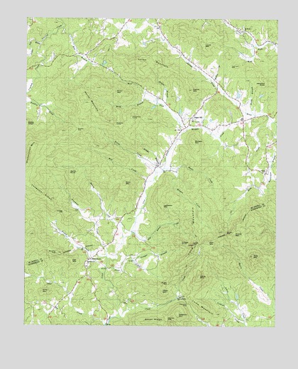
Sugar Hill, NC USGS Topographic Map
Click on map above to begin viewing in our Map Viewer.

This topographic map contains these locations and features:
Feature Name Type Latitude Longitude GNIS ID View Map
Bradley GapGapN35.5807°W82.0996°981809View Map
Bridge BranchStreamN35.5632°W82.0598°981872View Map
Bright BranchStreamN35.5893°W82.0554°981897View Map
Brushy TopSummitN35.5296°W82.1082°1019344View Map
Chalk CreekStreamN35.5037°W82.0765°982989View Map
Chalk MountainSummitN35.5137°W82.0562°1019598View Map
Dicks MountainSummitN35.5143°W82.1151°984179View Map
Elliot CreekStreamN35.5621°W82.0596°984726View Map
Elliot MountainSummitN35.5582°W82.0751°984727View Map
Frasheur CreekStreamN35.5271°W82.0834°1023984View Map
French MountainSummitN35.5962°W82.0426°1020364View Map
Glaghorn MountainSummitN35.5051°W82.0482°1024750View Map
Grassy KnobSummitN35.5343°W82.0479°985966View Map
Grassy MountainSummitN35.5387°W82.0209°1020522View Map
Greasy CreekStreamN35.5282°W82.0837°1024000View Map
Gringer BranchStreamN35.5265°W82.0701°986163View Map
Harris CreekStreamN35.5360°W82.0754°986445View Map
Harris MountainSummitN35.5201°W82.0379°986453View Map
Harris MountainSummitN35.5887°W82.0921°1020628View Map
Haw BranchStreamN35.6212°W82.1068°986508View Map
Haynes GapGapN35.5037°W82.0532°986551View Map
Heddrick KnobSummitN35.5987°W82.0051°1020669View Map
Hicks BranchStreamN35.5865°W82.0115°1024749View Map
Jones MountainSummitN35.6079°W82.0704°987759View Map
Lawing CemeteryCemeteryN35.5629°W82.0054°988218View Map
Ledbetter MountainSummitN35.5493°W82.0573°1021125View Map
Ledbetter RidgeRidgeN35.5521°W82.1137°988280View Map
Lewis CreekStreamN35.5012°W82.0151°988395View Map
Lewis MountainSummitN35.6140°W82.0365°1021138View Map
Little Toe RiverStreamN35.6146°W82.1176°1024112View Map
Long MountainSummitN35.5371°W82.0412°1024118View Map
Lump MountainSummitN35.5082°W82.0345°1021308View Map
Marks CreekStreamN35.5637°W82.0518°989344View Map
Mike MountainSummitN35.5287°W82.0112°989840View Map
Mill CreekStreamN35.5585°W82.0646°989924View Map
Montford Cove ChurchChurchN35.5257°W82.0932°1021516View Map
Montford Cove Church CemeteryCemeteryN35.5245°W82.0935°2779011View Map
Morgan CreekStreamN35.5787°W82.0476°1024162View Map
Morgan CreekStreamN35.5640°W82.0557°990228View Map
Morgan MountainSummitN35.5757°W82.0412°1021533View Map
Mount Pleasant ChurchChurchN35.6193°W82.0168°990538View Map
Oak MountainSummitN35.5265°W82.1018°1021699View Map
Old Boney CreekStreamN35.5379°W82.0715°991533View Map
Otter CreekStreamN35.5007°W82.0843°1024199View Map
Otter Creek (historical)Populated PlaceN35.5204°W82.0943°1008456View Map
Painters GapGapN35.5096°W82.0437°991793View Map
Pennycove LumpSummitN35.5848°W82.0729°992039View Map
Piney MountainSummitN35.5951°W82.0807°1021964View Map
PinnacleSummitN35.5329°W82.0407°1023582View Map
Queen GapGapN35.5165°W82.0501°992944View Map
Redcove LumpSummitN35.5823°W82.0807°1022202View Map
Rich MountainSummitN35.5343°W82.0348°1022267View Map
Rock CreekStreamN35.5835°W82.0018°1024269View Map
Sandy KnobSummitN35.5615°W82.1032°1022491View Map
Shoal RidgeRidgeN35.5021°W82.0612°994753View Map
Stone CreekStreamN35.5237°W82.0837°995531View Map
Sugar HillPopulated PlaceN35.5846°W82.0423°1022825View Map
Sugar Hill - Montford Cove Volunteer Fire DepartmentBuildingN35.5850°W82.0417°2639600View Map
Township of Montford CoveCivilN35.5726°W82.0701°1026897View Map
Two Inch GapGapN35.6057°W82.0237°996391View Map
Welcome Home ChurchChurchN35.5115°W82.0479°1027478View Map
Welcome Home Church CemeteryCemeteryN35.5118°W82.0481°2779014View Map
West Fork Cove CreekStreamN35.5787°W82.0476°1024400View Map
West Fork Goose CreekStreamN35.6151°W82.0043°997014View Map
WhitehousePopulated PlaceN35.5271°W82.0918°1023216View Map
Wildcat GapGapN35.5468°W82.1059°997315View Map
Wilson BranchStreamN35.5990°W82.0315°997432View Map
Windy GapGapN35.5376°W82.0248°997480View Map
Wood BranchStreamN35.5918°W82.0601°997561View Map

Note: Coordinates in the location and feature list above are referenced to NAD83 datum.


Copyright (C) 2008-2024 Ryan Niemi / Sunset Dynamics ... All Rights Reserved