TopoQuest Logo
Do you find TopoQuest useful?
Help keep TopoQuest running and adding new maps/features by donating!
Bitcoin:  19c7KJd3qBynnjoSw5npx9KScwjBe4ifkT
Litecoin:  LXs6TkuXGGXo1vDsWCkWVdjQX94eUKd6ui
Home View Maps Find Maps Find Places Resources & Links


Moffitt Hill, North Carolina Topographic Map

USGS Map Title: Moffitt Hill, NC
USGS Map MRC: 35082E2
DRG (GeoTIFF) Download: o35082e2.tif


Neighboring USGS Topographic Map Quads:


  Montreat, NC  
35082F3
 

  Old Fort, NC  
35082F2
 

  Marion West, NC  
35082F1
 

  Black Mountain, NC  
35082E3
 

  Moffitt Hill, NC  
35082E2
 

  Sugar Hill, NC  
35082E1
 

  Bat Cave, NC  
35082D3
 

  Lake Lure, NC  
35082D2
 

  Shingle Hollow, NC  
35082D1


Map MRC Location:

N36°
W83°
N36°
W82°
H8 H7 H6 H5 H4 H3 H2 H1
G8 G7 G6 G5 G4 G3 G2 G1
F8 F7 F6 F5 F4 F3 F2 F1
E8 E7 E6 E5 E4 E3 E2 E1
D8 D7 D6 D5 D4 D3 D2 D1
C8 C7 C6 C5 C4 C3 C2 C1
B8 B7 B6 B5 B4 B3 B2 B1
A8 A7 A6 A5 A4 A3 A2 A1
N35°
W83°
N35°
W82°

Moffitt Hill, NC USGS 1:24K Topographic Map Preview:
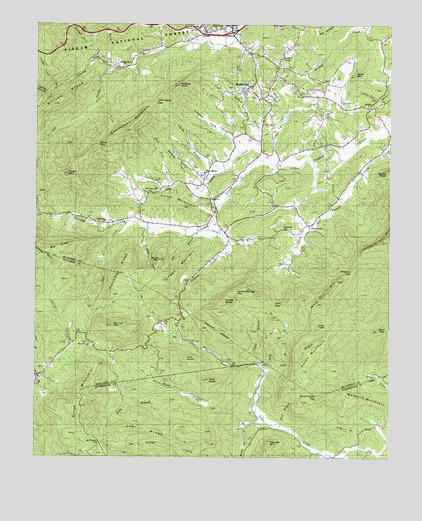
Moffitt Hill, NC USGS Topographic Map
Click on map above to begin viewing in our Map Viewer.

This topographic map contains these locations and features:
Feature Name Type Latitude Longitude GNIS ID View Map
Allison CoveValleyN35.5801°W82.1899°1008691View Map
Bailey CreekStreamN35.5093°W82.1754°1023800View Map
Bailey RidgeRidgeN35.5793°W82.1251°1023801View Map
Bear GapGapN35.5371°W82.1254°1009003View Map
Bethel ChurchChurchN35.5746°W82.1882°1018131View Map
Bethlehem ChurchChurchN35.6018°W82.1329°1009227View Map
Big BranchStreamN35.5651°W82.1921°1009264View Map
Big RidgeRidgeN35.6240°W82.1443°1009370View Map
Big RidgeRidgeN35.5607°W82.2396°1009362View Map
Bird CreekStreamN35.5685°W82.2173°1009420View Map
Bradley CreekStreamN35.5910°W82.1251°1023847View Map
Camp CreekStreamN35.5857°W82.1507°1009953View Map
Camp ElliottLocaleN35.5246°W82.2048°1009959View Map
Cane BranchStreamN35.5248°W82.1679°1023874View Map
Catawba Falls ChurchChurchN35.6135°W82.2187°1027389View Map
Cherry Springs ChurchChurchN35.5823°W82.1904°1023903View Map
Chestnut BranchStreamN35.6048°W82.2448°1010227View Map
Clarks BranchStreamN35.5815°W82.1865°1010299View Map
Clover Patch BranchStreamN35.6071°W82.2418°1010338View Map
Coon GapGapN35.5382°W82.1462°1010463View Map
Crooked Creek Township Volunteer Fire DepartmentBuildingN35.5743°W82.1883°2639839View Map
DavistownPopulated PlaceN35.5618°W82.1521°1019926View Map
Davistown CemeteryCemeteryN35.5662°W82.1632°1024548View Map
Dill BranchStreamN35.5657°W82.1548°1010815View Map
Ditney KnobSummitN35.5451°W82.1829°1019978View Map
Dutchman RidgeRidgeN35.5529°W82.2193°1010954View Map
Edmondson MountainSummitN35.5940°W82.2207°1011023View Map
England GapGapN35.5537°W82.1373°1011092View Map
Flint KnobSummitN35.5285°W82.1962°1020289View Map
Fork KnobSummitN35.5223°W82.1882°1011314View Map
Guthrie BranchStreamN35.5890°W82.1712°1011783View Map
Hickorynut MountainSummitN35.5685°W82.1251°1024035View Map
Hicks MountainSummitN35.5815°W82.2387°1012030View Map
Hodges CreekStreamN35.5662°W82.2093°1012090View Map
Jacks MountainSummitN35.6107°W82.1373°1020919View Map
Jackson CreekStreamN35.5657°W82.1890°1012409View Map
Jeter (historical)Populated PlaceN35.5071°W82.1587°1008445View Map
Joel RidgeRidgeN35.5076°W82.2054°1012493View Map
Jordan BranchStreamN35.5840°W82.1657°1012564View Map
Koon BranchStreamN35.5032°W82.1343°1012650View Map
Lackey TownPopulated PlaceN35.6118°W82.1648°1021074View Map
Lake Lure Mountain EstatesPopulated PlaceN35.5048°W82.1707°1008446View Map
Laurel CreekStreamN35.5232°W82.2484°1012724View Map
Left Prong Catawba RiverStreamN35.6118°W82.2218°1012812View Map
Little Crooked CreekStreamN35.5860°W82.1701°1012951View Map
Little Deep GapGapN35.6029°W82.2079°1024096View Map
Little MountainSummitN35.5743°W82.2032°1021214View Map
Locust Spring GapGapN35.5473°W82.1798°1013072View Map
Logan MountainSummitN35.5476°W82.2062°1013081View Map
Long BranchStreamN35.5257°W82.1651°1013116View Map
Loom CreekStreamN35.5929°W82.1257°1013192View Map
Lytle BranchStreamN35.5643°W82.1848°1013274View Map
Major MountainSummitN35.5573°W82.2057°1021328View Map
Medford MountainSummitN35.5168°W82.1326°1021405View Map
Mill CreekStreamN35.6248°W82.1754°1024151View Map
Moffitt HillPopulated PlaceN35.6057°W82.1759°1021507View Map
Mount Hebron ChurchChurchN35.5685°W82.2251°1013738View Map
Mount Pleasant CemeteryCemeteryN35.5044°W82.2269°1013761View Map
Padgett CoveValleyN35.5913°W82.1796°1014176View Map
Pine Cove BranchStreamN35.5779°W82.2015°1014416View Map
Pine Cove CemeteryCemeteryN35.5776°W82.2062°1014417View Map
Roan Horse TopSummitN35.5179°W82.1496°1022308View Map
Rocky MountainSummitN35.5310°W82.1509°1022372View Map
Rosy BranchStreamN35.5201°W82.2018°1015094View Map
Round MountainSummitN35.5379°W82.2221°1015109View Map
Salem ChurchChurchN35.5998°W82.1479°1015175View Map
Sally BranchStreamN35.5243°W82.1671°1015180View Map
Sally GapGapN35.5446°W82.1626°1015185View Map
Sank GapGapN35.5901°W82.2276°1015246View Map
Spring BranchStreamN35.6129°W82.2240°1015739View Map
Stone MountainSummitN35.5179°W82.2332°1015857View Map
Stone Mountain ChurchChurchN35.5323°W82.2293°1018130View Map
Sunnyview ChurchChurchN35.6032°W82.1421°1018132View Map
Taylor CreekStreamN35.5101°W82.1682°1024345View Map
Township of Crooked CreekCivilN35.5803°W82.1718°1026892View Map
Wash BranchStreamN35.5096°W82.1626°1016450View Map
Wildcat KnobSummitN35.6073°W82.1993°1016677View Map
Wolf Pen MountainSummitN35.5443°W82.1482°1016783View Map
Youngs Fork CreekStreamN35.6151°W82.2284°1024418View Map

Note: Coordinates in the location and feature list above are referenced to NAD83 datum.


Copyright (C) 2008-2024 Ryan Niemi / Sunset Dynamics ... All Rights Reserved