TopoQuest Logo
Do you find TopoQuest useful?
Help keep TopoQuest running and adding new maps/features by donating!
Bitcoin:  19c7KJd3qBynnjoSw5npx9KScwjBe4ifkT
Litecoin:  LXs6TkuXGGXo1vDsWCkWVdjQX94eUKd6ui
Home View Maps Find Maps Find Places Resources & Links


Martins Mills, Tennessee Topographic Map

USGS Map Title: Martins Mills, TN
USGS Map MRC: 35087B8
DRG (GeoTIFF) Download: o35087b8.tif


Neighboring USGS Topographic Map Quads:


  Olivehill, TN  
35088C1
 

  Eagle Creek, TN  
35087C8
 

  Waynesboro, TN  
35087C7
 

  Wolf Pit Ridge, TN  
35088B1
 

  Martins Mills, TN  
35087B8
 

  Three Churches, TN  
35087B7
 

  Lowryville, TN  
35088A1
 

  Ransom Stand, TN  
35087A8
 

  Cypress Inn, TN  
35087A7


Map MRC Location:

N36°
W88°
N36°
W87°
H8 H7 H6 H5 H4 H3 H2 H1
G8 G7 G6 G5 G4 G3 G2 G1
F8 F7 F6 F5 F4 F3 F2 F1
E8 E7 E6 E5 E4 E3 E2 E1
D8 D7 D6 D5 D4 D3 D2 D1
C8 C7 C6 C5 C4 C3 C2 C1
B8 B7 B6 B5 B4 B3 B2 B1
A8 A7 A6 A5 A4 A3 A2 A1
N35°
W88°
N35°
W87°

Martins Mills, TN USGS 1:24K Topographic Map Preview:
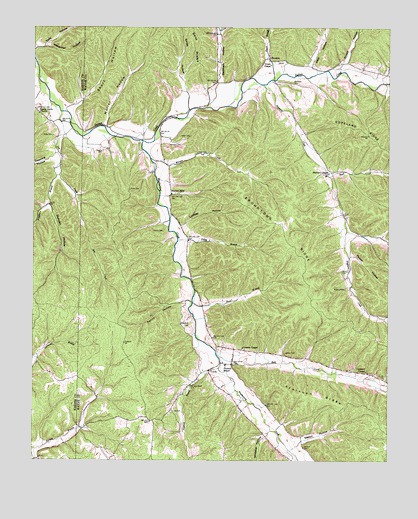
Martins Mills, TN USGS Topographic Map
Click on map above to begin viewing in our Map Viewer.

This topographic map contains these locations and features:
Feature Name Type Latitude Longitude GNIS ID View Map
Alexander HollowValleyN35.2444°W87.9953°1275559View Map
Arnold BranchStreamN35.2384°W87.8931°1302698View Map
Arnold HollowValleyN35.2404°W87.8911°1275894View Map
Atkinson RidgeRidgeN35.1440°W87.9000°1275972View Map
Bear CreekStreamN35.1554°W87.9353°1276584View Map
Beckham HollowValleyN35.2341°W87.9347°1276744View Map
Beckham Hollow BranchStreamN35.2270°W87.9395°1646832View Map
Browntown (historical)Populated PlaceN35.1934°W87.9153°1302708View Map
Browntown RidgeRidgeN35.1912°W87.9120°1278636View Map
Buck CreekStreamN35.2090°W87.8970°1278807View Map
Bundrant BranchStreamN35.2342°W87.8772°1279001View Map
Commissioner District 5CivilN35.1485°W87.8767°2464503View Map
Copeland CemeteryCemeteryN35.1637°W87.9450°1281240View Map
Copeland ChapelChurchN35.1509°W87.8825°1281244View Map
Davana CemeteryCemeteryN35.2145°W87.9761°1282081View Map
Davis BranchStreamN35.2354°W87.9161°1282130View Map
Downing HollowValleyN35.2125°W87.9934°1303439View Map
Dry CreekStreamN35.2256°W87.9906°1282905View Map
Duncan HollowValleyN35.2066°W87.9922°1283164View Map
Duncans BranchStreamN35.1987°W87.9942°1314167View Map
Eaton CemeteryCemeteryN35.2184°W87.9489°1283444View Map
Gillis CemeteryCemeteryN35.2190°W87.9939°1285420View Map
Grace ChapelChurchN35.2395°W87.9170°1285774View Map
Greeson ChapelChurchN35.1573°W87.9261°1286229View Map
Greeson Chapel CemeteryCemeteryN35.1573°W87.9256°1641804View Map
Harville CemeteryCemeteryN35.2001°W87.9856°1323820View Map
Herndon CemeteryCemeteryN35.2165°W87.9528°1287494View Map
HoustonPopulated PlaceN35.2415°W87.9178°1288501View Map
Houston School (historical)SchoolN35.2370°W87.9222°1302761View Map
Hunt BranchStreamN35.1706°W87.9436°1288709View Map
Jerrolds CemeteryCemeteryN35.2181°W87.9878°1323841View Map
Lawson CemeteryCemeteryN35.1562°W87.9114°1290804View Map
Lindsey HollowValleyN35.1925°W87.9480°1291326View Map
LuttsPopulated PlaceN35.1512°W87.9381°1292318View Map
Lutts CemeteryCemeteryN35.1392°W87.9511°1292320View Map
Lutts Post OfficePost OfficeN35.1510°W87.9396°1649045View Map
Lutts Volunteer Fire DepartmentBuildingN35.1526°W87.9311°2653802View Map
Martin CemeteryCemeteryN35.1912°W87.9545°1292801View Map
Martins MillsPopulated PlaceN35.2020°W87.9520°1292851View Map
Martins Mills School (historical)SchoolN35.2117°W87.9542°1302772View Map
Melson CemeteryCemeteryN35.1795°W87.8914°1293560View Map
Morgan CreekStreamN35.2123°W87.9592°1294364View Map
Mount Heber CemeteryCemeteryN35.2337°W87.9095°1294623View Map
Muller HollowValleyN35.2219°W87.9752°1295079View Map
Muller Hollow BranchStreamN35.2212°W87.9750°1646850View Map
Neighbors BranchStreamN35.2106°W87.9914°1295356View Map
Nowlin Family CemeteryCemeteryN35.2329°W87.9020°1641865View Map
Perry HollowValleyN35.1712°W87.9463°1297217View Map
Petit HollowValleyN35.2391°W87.9026°1297260View Map
Petit Hollow BranchStreamN35.2367°W87.9006°1646852View Map
Pinhook BranchStreamN35.1517°W87.9345°1297662View Map
Pinhook Elementary SchoolSchoolN35.1526°W87.9323°1648466View Map
Pusser HollowValleyN35.1841°W87.8882°1298717View Map
Rayburn CemeteryCemeteryN35.2337°W87.9170°1641892View Map
Rayburn ChapelChurchN35.2084°W87.8961°1299004View Map
Rayburn CreekStreamN35.2337°W87.9195°1299005View Map
Rayburn School (historical)SchoolN35.2084°W87.8959°1302790View Map
Robbins CemeteryCemeteryN35.1745°W87.8900°1299587View Map
Rose CemeteryCemeteryN35.2034°W87.9664°1300065View Map
Rose CemeteryCemeteryN35.2140°W87.9428°1300066View Map
Seaton HollowValleyN35.1305°W87.9060°1301001View Map
Shady Grove ChurchChurchN35.2254°W87.9984°1301165View Map
Shady Grove School (historical)SchoolN35.2240°W87.9973°1323942View Map
Short HollowValleyN35.2272°W87.9871°1270204View Map
Sinclair CemeteryCemeteryN35.1873°W87.9431°1641907View Map
Sinclair CemeteryCemeteryN35.1617°W87.9353°1641908View Map
Smith HollowValleyN35.2315°W87.9460°1270692View Map
Stribling CemeteryCemeteryN35.1334°W87.9028°1641910View Map
Thompson CemeteryCemeteryN35.1887°W87.8928°1641914View Map
Tilley BranchStreamN35.1890°W87.9495°1272640View Map
Todd HollowValleyN35.2439°W87.9996°1272715View Map
Weatherford CreekStreamN35.2173°W87.9623°1273975View Map
Weatherford-Bear Creek Dam Number TwoDamN35.1467°W87.8767°1301613View Map
Weatherford-Bear Creek Lake Number TwoReservoirN35.1468°W87.8771°1301612View Map
Whitaker HollowValleyN35.1320°W87.9179°1274326View Map
White CemeteryCemeteryN35.2320°W87.8778°1641927View Map
Wilkerson CemeteryCemeteryN35.2267°W87.9989°1274585View Map

Note: Coordinates in the location and feature list above are referenced to NAD83 datum.


Copyright (C) 2008-2024 Ryan Niemi / Sunset Dynamics ... All Rights Reserved