TopoQuest Logo
Do you find TopoQuest useful?
Help keep TopoQuest running and adding new maps/features by donating!
Bitcoin:  19c7KJd3qBynnjoSw5npx9KScwjBe4ifkT
Litecoin:  LXs6TkuXGGXo1vDsWCkWVdjQX94eUKd6ui
Home View Maps Find Maps Find Places Resources & Links


Waynesboro, Tennessee Topographic Map

USGS Map Title: Waynesboro, TN
USGS Map MRC: 35087C7
DRG (GeoTIFF) Download: o35087c7.tif


Neighboring USGS Topographic Map Quads:


  Clifton, TN  
35087D8
 

  Leatherwood, TN  
35087D7
 

  Topsy, TN  
35087D6
 

  Eagle Creek, TN  
35087C8
 

  Waynesboro, TN  
35087C7
 

  Waynesboro East, TN  
35087C6
 

  Martins Mills, TN  
35087B8
 

  Three Churches, TN  
35087B7
 

  Collinwood, TN  
35087B6


Map MRC Location:

N36°
W88°
N36°
W87°
H8 H7 H6 H5 H4 H3 H2 H1
G8 G7 G6 G5 G4 G3 G2 G1
F8 F7 F6 F5 F4 F3 F2 F1
E8 E7 E6 E5 E4 E3 E2 E1
D8 D7 D6 D5 D4 D3 D2 D1
C8 C7 C6 C5 C4 C3 C2 C1
B8 B7 B6 B5 B4 B3 B2 B1
A8 A7 A6 A5 A4 A3 A2 A1
N35°
W88°
N35°
W87°

Waynesboro, TN USGS 1:24K Topographic Map Preview:
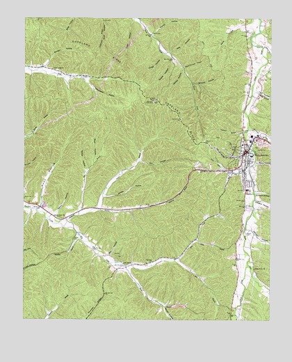
Waynesboro, TN USGS Topographic Map
Click on map above to begin viewing in our Map Viewer.

This topographic map contains these locations and features:
Feature Name Type Latitude Longitude GNIS ID View Map
Banjo BranchStreamN35.2723°W87.8231°1276264View Map
Belew HollowValleyN35.3154°W87.7573°1326580View Map
Bennett Cole CemeteryCemeteryN35.2709°W87.8303°1641752View Map
Black CemeteryCemeteryN35.3223°W87.7772°1641755View Map
Boyd HollowValleyN35.3151°W87.8396°1278112View Map
Brewer CemeteryCemeteryN35.2828°W87.8495°1278292View Map
Calvary Baptist ChurchChurchN35.3081°W87.7636°1320125View Map
Cantrell SubdivisionPopulated PlaceN35.3009°W87.7611°1302710View Map
Cave SpringSpringN35.2732°W87.8245°1279944View Map
Chalk CreekStreamN35.2726°W87.7611°1269437View Map
Chambers HollowValleyN35.3501°W87.8454°1280216View Map
Choate CemeteryCemeteryN35.3628°W87.7595°1641773View Map
City of WaynesboroCivilN35.3229°W87.7599°2405696View Map
Collier CemeteryCemeteryN35.2540°W87.7653°1641774View Map
Copeland BranchStreamN35.3279°W87.7628°1281238View Map
Copeland RidgeRidgeN35.3484°W87.8153°1281252View Map
Culley HollowValleyN35.3605°W87.8045°1281811View Map
Davis HollowValleyN35.3748°W87.7592°1282186View Map
Dogwood HeightsPopulated PlaceN35.3120°W87.7547°1302738View Map
Dry HollowValleyN35.3156°W87.8165°1282988View Map
Eagle HollowValleyN35.3745°W87.8199°1283295View Map
Forrest HillsPopulated PlaceN35.3009°W87.7675°1302744View Map
Green River (historical)Populated PlaceN35.2709°W87.7578°1302751View Map
Green River ChurchChurchN35.2712°W87.7578°1286121View Map
Greenwood CemeteryCemeteryN35.3237°W87.7631°1641806View Map
Greeson Family CemeteryCemeteryN35.3295°W87.7653°1641805View Map
Greeson HollowValleyN35.2995°W87.7573°1326598View Map
Grover HollowValleyN35.3591°W87.8008°1286359View Map
Gunn HollowValleyN35.2969°W87.8667°1286435View Map
Gunn Hollow BranchStreamN35.2956°W87.8681°1646837View Map
Hardin HollowValleyN35.2557°W87.8035°1286832View Map
Henry HollowValleyN35.2923°W87.8618°1287449View Map
Hog CreekStreamN35.2901°W87.8570°1287976View Map
Hog Creek CemeteryCemeteryN35.2742°W87.8095°1287979View Map
Huckaba BranchStreamN35.2859°W87.8478°1288583View Map
Hurricane CreekStreamN35.3295°W87.7611°1326600View Map
Irwin BranchStreamN35.2831°W87.7878°1289059View Map
Jess HollowValleyN35.3610°W87.8011°1289414View Map
Johnson HollowValleyN35.2874°W87.7593°1326602View Map
Jordan HollowValleyN35.3010°W87.8339°1289840View Map
Kea CemeteryCemeteryN35.3037°W87.7636°1289918View Map
Keeton HollowValleyN35.3537°W87.7545°1326604View Map
Kelley CemeteryCemeteryN35.3495°W87.7553°1289998View Map
Killburn HollowValleyN35.3026°W87.7575°1326605View Map
Lay SpringSpringN35.2951°W87.8220°1641835View Map
Leatherwood CemeteryCemeteryN35.2926°W87.8564°1641837View Map
Leatherwood CemeteryCemeteryN35.2920°W87.8500°1641838View Map
Leatherwood ChurchChurchN35.2926°W87.8539°1290885View Map
Lone Cedar ChurchChurchN35.3540°W87.8611°1291838View Map
Longview SubdivisionPopulated PlaceN35.3104°W87.7772°1302769View Map
Mill BranchStreamN35.2742°W87.7984°1293811View Map
Mink BranchStreamN35.3454°W87.7592°1326617View Map
Morgan HollowValleyN35.3547°W87.8658°1294369View Map
Morris CemeteryCemeteryN35.3003°W87.8747°1294415View Map
Morrow CemeteryCemeteryN35.2956°W87.7553°1641856View Map
Negro HollowValleyN35.3176°W87.7648°1302778View Map
Negro Hollow BranchStreamN35.3204°W87.7589°1302779View Map
Old Town CemeteryCemeteryN35.3203°W87.7570°1296382View Map
Parker BranchStreamN35.2962°W87.8389°1296792View Map
Peach Orchard HollowValleyN35.3544°W87.7941°1297049View Map
Ralph Cole CemeteryCemeteryN35.2959°W87.8403°1641890View Map
Ray CemeteryCemeteryN35.2756°W87.8275°1641891View Map
Ray CemeteryCemeteryN35.2770°W87.8289°1298989View Map
Ray HollowValleyN35.2764°W87.8315°1298999View Map
Rocky Mill BranchStreamN35.3120°W87.7611°1299910View Map
Rose BranchStreamN35.2931°W87.8472°1300061View Map
Rose CemeteryCemeteryN35.2973°W87.8347°1641895View Map
Shakerag BranchStreamN35.2901°W87.8572°1301203View Map
Shields CemeteryCemeteryN35.2853°W87.7620°1270058View Map
Simmons BranchStreamN35.3631°W87.7539°1326567View Map
Talley CemeteryCemeteryN35.2745°W87.8184°1641912View Map
Walker HollowValleyN35.3109°W87.8434°1273624View Map
Warren CemeteryCemeteryN35.3692°W87.8103°1273825View Map
Warren HollowValleyN35.3681°W87.8107°1273835View Map
Wayne County CourthouseBuildingN35.3198°W87.7625°1302812View Map
Wayne County Farm (historical)LocaleN35.3009°W87.8345°1302813View Map
Wayne County High SchoolSchoolN35.3037°W87.7620°1302815View Map
Wayne County Sheriff's OfficeBuildingN35.3247°W87.7712°2766043View Map
Wayne County Vocational CenterSchoolN35.3040°W87.7611°1641922View Map
Wayne Medical CenterHospitalN35.3247°W87.7570°1302814View Map
WaynesboroPopulated PlaceN35.3195°W87.7622°1326575View Map
Waynesboro City Fire DepartmentBuildingN35.3245°W87.7609°2653798View Map
Waynesboro Elementary SchoolSchoolN35.3131°W87.7622°1302816View Map
Waynesboro First Baptist ChurchChurchN35.3165°W87.7631°1320127View Map
Waynesboro Industrial ParkLocaleN35.3262°W87.7597°1302817View Map
Waynesboro Middle SchoolSchoolN35.3123°W87.7628°1302818View Map
Waynesboro Police DepartmentBuildingN35.3201°W87.7617°2765862View Map
Waynesboro Post OfficePost OfficeN35.3122°W87.7638°1649052View Map
Whitey HollowValleyN35.3539°W87.7947°1274474View Map
Wildcat HollowValleyN35.3482°W87.7898°1274537View Map
York HollowValleyN35.3449°W87.7579°1326577View Map

Note: Coordinates in the location and feature list above are referenced to NAD83 datum.


Copyright (C) 2008-2024 Ryan Niemi / Sunset Dynamics ... All Rights Reserved