TopoQuest Logo
Do you find TopoQuest useful?
Help keep TopoQuest running and adding new maps/features by donating!
Bitcoin:  19c7KJd3qBynnjoSw5npx9KScwjBe4ifkT
Litecoin:  LXs6TkuXGGXo1vDsWCkWVdjQX94eUKd6ui
Home View Maps Find Maps Find Places Resources & Links


Maysville East, Kentucky Topographic Map

USGS Map Title: Maysville East, KY
USGS Map MRC: 38083F6
DRG (GeoTIFF) Download: o38083f6.tif


Neighboring USGS Topographic Map Quads:


  Russellville, OH  
38083G7
 

  Decatur, OH  
38083G6
 

  West Union, OH  
38083G5
 

  Maysville West, KY  
38083F7
 

  Maysville East, KY  
38083F6
 

  Manchester Islands, KY  
38083F5
 

  Mays Lick, KY  
38083E7
 

  Orangeburg, KY  
38083E6
 

  Tollesboro, KY  
38083E5


Map MRC Location:

N39°
W84°
N39°
W83°
H8 H7 H6 H5 H4 H3 H2 H1
G8 G7 G6 G5 G4 G3 G2 G1
F8 F7 F6 F5 F4 F3 F2 F1
E8 E7 E6 E5 E4 E3 E2 E1
D8 D7 D6 D5 D4 D3 D2 D1
C8 C7 C6 C5 C4 C3 C2 C1
B8 B7 B6 B5 B4 B3 B2 B1
A8 A7 A6 A5 A4 A3 A2 A1
N38°
W84°
N38°
W83°

Maysville East, KY USGS 1:24K Topographic Map Preview:
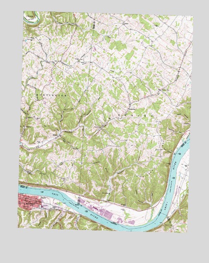
Maysville East, KY USGS Topographic Map
Click on map above to begin viewing in our Map Viewer.

This topographic map contains these locations and features:
Feature Name Type Latitude Longitude GNIS ID View Map
Acacia School (historical)SchoolN38.6534°W83.6841°1055809View Map
Bates (historical)Populated PlaceN38.6345°W83.7038°2362879View Map
Beasley CemeteryCemeteryN38.6878°W83.7385°1037734View Map
Big RunStreamN38.6781°W83.7213°1038011View Map
Bloomhuff School (historical)SchoolN38.7106°W83.6846°1055815View Map
Bradford CemeteryCemeteryN38.6373°W83.6707°1038247View Map
Bradford CemeteryCemeteryN38.6426°W83.6844°1038248View Map
Bradford LandingLocaleN38.6306°W83.6816°1055817View Map
Bradford RunStreamN38.6776°W83.6296°1038252View Map
BradysvillePopulated PlaceN38.6954°W83.6705°1064477View Map
Bradyville Post Office (historical)Post OfficeN38.6954°W83.6705°1956155View Map
Brooks BarBarN38.6434°W83.7124°1829084View Map
Brooks Bar (historical)BarN38.6437°W83.7138°1053035View Map
Buckes BranchStreamN38.6302°W83.6443°2362884View Map
Bull Fork CreekStreamN38.6348°W83.7046°488356View Map
Buzzardroost CreekStreamN38.6292°W83.6741°1055824View Map
Carrs LandingLocaleN38.6429°W83.6430°1055826View Map
Carter HollowValleyN38.6415°W83.6530°1038846View Map
Chester Post Office (historical)Post OfficeN38.6403°W83.7416°2362889View Map
ClaytonPopulated PlaceN38.7437°W83.6755°1039153View Map
Coopers LandingLocaleN38.6450°W83.7483°2362891View Map
Crooked CreekStreamN38.6351°W83.6405°490381View Map
Dam Number 33 (historical)DamN38.6362°W83.7019°1055835View Map
Dayton Power and Light Rescue SquadBuildingN38.6420°W83.6917°2550284View Map
Dry RunStreamN38.6801°W83.7213°1039806View Map
Ebenezer ChurchChurchN38.7229°W83.7077°1080300View Map
Ebenezer ChurchyardCemeteryN38.7228°W83.7074°1699125View Map
Elk RunStreamN38.6306°W83.6541°1040127View Map
Ellis Grove CemeteryCemeteryN38.6534°W83.7146°1040149View Map
Ellis LandingLocaleN38.6370°W83.6974°1055836View Map
Ellis RunStreamN38.6815°W83.7194°1040152View Map
Ellis Run School (historical)SchoolN38.6873°W83.7216°1053059View Map
EllsberryPopulated PlaceN38.6792°W83.7210°1064613View Map
Ellsberry Post Office (historical)Post OfficeN38.6792°W83.7210°1965636View Map
Emon ChurchChurchN38.6890°W83.6827°1040198View Map
EvertonvillePopulated PlaceN38.6856°W83.6891°1065482View Map
Games School (historical)SchoolN38.7195°W83.7141°1053067View Map
Gilbert School (historical)SchoolN38.7190°W83.7360°1053069View Map
Ginger RidgeRidgeN38.6606°W83.6533°1040872View Map
Glendale School (historical)SchoolN38.6392°W83.6699°1055844View Map
Goose CreekStreamN38.6445°W83.7346°493005View Map
Grimes LandingLocaleN38.6320°W83.6858°1055847View Map
Hamilton School (historical)SchoolN38.7320°W83.6952°1055849View Map
HiettPopulated PlaceN38.7215°W83.7235°1055961View Map
Hiett Chapel CemeteryCemeteryN38.7340°W83.7421°1041541View Map
Hiett Post Office (historical)Post OfficeN38.7209°W83.7235°1965639View Map
Hills School (historical)SchoolN38.6642°W83.6477°1055856View Map
Holton Landing (historical)HarborN38.6465°W83.6364°2363005View Map
Hopewell CemeteryCemeteryN38.7434°W83.6502°1041767View Map
Hopewell FarmLocaleN38.7431°W83.6485°1699147View Map
Isaacs CreekStreamN38.6795°W83.6266°1042001View Map
J M Stuart Power PlantBuildingN38.6379°W83.6930°1731189View Map
Kemmeters LandingLocaleN38.6701°W83.6369°1055864View Map
Kennedy CreekStreamN38.6387°W83.7130°495647View Map
Kimballs LandingLocaleN38.6301°W83.6785°1055865View Map
Lickskillet BranchStreamN38.6545°W83.6824°1042554View Map
Little Threemile CreekStreamN38.6417°W83.7088°1067083View Map
Lock Number Twenty-Three (historical)DamN38.6365°W83.7031°2362905View Map
Manvels Landing (historical)LocaleN38.6381°W83.6389°2364887View Map
MaysvillePopulated PlaceN38.6412°W83.7444°517025View Map
McClelland RunStreamN38.6773°W83.6294°1066276View Map
McColm ChurchChurchN38.6723°W83.6458°1043154View Map
Meffords RunStreamN38.6851°W83.7060°1043209View Map
Mertz Memorial PlaygroundParkN38.6429°W83.7341°498081View Map
Opossum HollowValleyN38.6426°W83.6558°1055896View Map
Owl HollowValleyN38.6712°W83.6371°1044263View Map
Owl Hollow RunStreamN38.6704°W83.6366°1055899View Map
Paradise HillsPopulated PlaceN38.7067°W83.6477°1080301View Map
Parrs LandingLocaleN38.6315°W83.6513°1055902View Map
Pollard School (historical)SchoolN38.6898°W83.6449°1055906View Map
Ravenscroft ChapelChurchN38.6398°W83.6705°1044868View Map
Reader CemeteryCemeteryN38.6745°W83.7346°1044883View Map
Rogers LandingLocaleN38.6484°W83.6410°1055910View Map
Roths LandingLocaleN38.6479°W83.7246°1055967View Map
Roush School (historical)SchoolN38.7156°W83.6263°1055912View Map
Saint Pauls Railroad Station (historical)LocaleN38.6688°W83.6688°2364899View Map
Sand HillPopulated PlaceN38.6640°W83.6258°509007View Map
School Number 4 (historical)SchoolN38.7392°W83.6513°1055916View Map
Shinns LandingLocaleN38.6287°W83.6596°1055921View Map
Sleepy HollowValleyN38.6369°W83.7280°503676View Map
SlickawayPopulated PlaceN38.6837°W83.7463°1063020View Map
Star School (historical)SchoolN38.6734°W83.6771°1055923View Map
Stone Quarry LandingLocaleN38.6305°W83.6929°2362940View Map
Stuart Ash Pit Number 8 DamDamN38.6351°W83.6866°1079534View Map
Stuart Ash Pit Number 8 ReservoirReservoirN38.6351°W83.6866°1079535View Map
Sulphur Springs ChurchChurchN38.6465°W83.6821°1046855View Map
The Sand FillsFlatN38.6632°W83.6288°2363083View Map
The Upper LandingLocaleN38.6449°W83.7455°2362946View Map
Threemile CreekStreamN38.6420°W83.7083°1047049View Map
Township of HuntingtonCivilN38.7065°W83.7404°1085797View Map
Township of SpriggCivilN38.7043°W83.6505°1085685View Map
Wilsons Landing (historical)LocaleN38.6693°W83.6296°2363104View Map

Note: Coordinates in the location and feature list above are referenced to NAD83 datum.


Copyright (C) 2008-2024 Ryan Niemi / Sunset Dynamics ... All Rights Reserved