TopoQuest Logo
Do you find TopoQuest useful?
Help keep TopoQuest running and adding new maps/features by donating!
Bitcoin:  19c7KJd3qBynnjoSw5npx9KScwjBe4ifkT
Litecoin:  LXs6TkuXGGXo1vDsWCkWVdjQX94eUKd6ui
Home View Maps Find Maps Find Places Resources & Links


McKee, Kentucky Topographic Map

USGS Map Title: McKee, KY
USGS Map MRC: 37083D8
DRG (GeoTIFF) Download: o37083d8.tif


Neighboring USGS Topographic Map Quads:


  Alcorn, KY  
37084E1
 

  Leighton, KY  
37083E8
 

  Heidelberg, KY  
37083E7
 

  Sandgap, KY  
37084D1
 

  McKee, KY  
37083D8
 

  Sturgeon, KY  
37083D7
 

  Parrot, KY  
37084C1
 

  Tyner, KY  
37083C8
 

  Maulden, KY  
37083C7


Map MRC Location:

N38°
W84°
N38°
W83°
H8 H7 H6 H5 H4 H3 H2 H1
G8 G7 G6 G5 G4 G3 G2 G1
F8 F7 F6 F5 F4 F3 F2 F1
E8 E7 E6 E5 E4 E3 E2 E1
D8 D7 D6 D5 D4 D3 D2 D1
C8 C7 C6 C5 C4 C3 C2 C1
B8 B7 B6 B5 B4 B3 B2 B1
A8 A7 A6 A5 A4 A3 A2 A1
N37°
W84°
N37°
W83°

McKee, KY USGS 1:24K Topographic Map Preview:
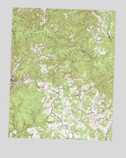
McKee, KY USGS Topographic Map
Click on map above to begin viewing in our Map Viewer.

This topographic map contains these locations and features:
Feature Name Type Latitude Longitude GNIS ID View Map
Adkins School (historical)SchoolN37.3826°W83.9600°2505030View Map
AtkinstownPopulated PlaceN37.3831°W83.9627°510321View Map
Beulah LakeReservoirN37.3775°W83.9093°2094637View Map
Big Buck LickStreamN37.4862°W83.9108°510633View Map
Bills BranchStreamN37.4318°W83.9991°510724View Map
BradshawPopulated PlaceN37.4251°W83.9633°510889View Map
Bradshaw Post Office (historical)Post OfficeN37.4248°W83.9633°2505042View Map
Brushy RidgeRidgeN37.4931°W83.9783°510984View Map
City of McKeeCivilN37.4302°W83.9870°2405051View Map
Elsam ForkStreamN37.4659°W83.9169°512061View Map
Flat Hollow ForkStreamN37.3979°W83.9692°2505080View Map
Gray HawkPopulated PlaceN37.3951°W83.9402°512409View Map
Gray Hawk Fire DepartmentBuildingN37.3942°W83.9373°2636305View Map
Gray Hawk Post Office (historical)Post OfficeN37.3958°W83.9399°2505018View Map
Griffee BranchStreamN37.4772°W83.8840°2504896View Map
Guys BranchStreamN37.4401°W83.9246°512489View Map
Hayes BranchStreamN37.4308°W83.9968°2504897View Map
Huff (historical)Populated PlaceN37.4190°W83.9149°2504901View Map
Huff ChurchChurchN37.4181°W83.9158°512833View Map
Huff School (historical)SchoolN37.4176°W83.9157°2504990View Map
Hughes ForkStreamN37.4648°W83.9169°512844View Map
Jacks BranchStreamN37.4220°W83.9141°512953View Map
Jackson County Ambulance ServiceBuildingN37.4305°W83.9982°2719134View Map
Jackson County High School (historical)SchoolN37.4221°W83.9473°2504907View Map
Jackson County Sheriff's OfficeBuildingN37.4306°W83.9979°2767453View Map
Lake CreekStreamN37.4981°W83.9599°513188View Map
Lime Kiln BranchStreamN37.4778°W83.9144°2504917View Map
Lime Kiln ForkStreamN37.4659°W83.9269°513423View Map
Lime Kiln RidgeRidgeN37.4765°W83.9380°513424View Map
MacedoniaPopulated PlaceN37.4587°W83.9658°513747View Map
Macedonia ChurchChurchN37.4609°W83.9692°2505021View Map
McCammon BranchStreamN37.3801°W83.9846°513844View Map
McKeePopulated PlaceN37.4304°W83.9980°513872View Map
McKee DivisionCivilN37.4538°W83.9586°1937123View Map
McKee Fire Department Station 1BuildingN37.4300°W83.9986°2636353View Map
McKee Fire Department Station 2BuildingN37.4268°W83.9967°2637282View Map
McKee Post OfficePost OfficeN37.4304°W83.9997°2504925View Map
McKee SchoolSchoolN37.4423°W83.9921°516604View Map
McKee Work CenterLocaleN37.4329°W83.9721°516607View Map
Middle Fork Elsam ForkStreamN37.4654°W83.9421°513929View Map
Mill CreekStreamN37.3793°W83.9930°513981View Map
Mount Bethel ChurchChurchN37.4954°W83.8935°514084View Map
Muncey Post Office (historical)Post OfficeN37.4773°W83.8958°2505022View Map
Neil HollowValleyN37.4527°W83.9817°514224View Map
New ZionPopulated PlaceN37.4709°W83.8958°514251View Map
New Zion Post Office (historical)Post OfficeN37.4720°W83.8968°2505002View Map
New Zion RidgeRidgeN37.4742°W83.8946°2504933View Map
New Zion School (historical)SchoolN37.4755°W83.9009°2504934View Map
Oak Grove (historical)Populated PlaceN37.3754°W83.9037°2504935View Map
Old Pigeon RoostLocaleN37.4389°W83.9668°2505003View Map
Orpha Post Office (historical)Post OfficeN37.4745°W83.9002°2504939View Map
Otter BranchStreamN37.4866°W83.9052°2504940View Map
Panther BranchStreamN37.4840°W83.9084°2504942View Map
Pilgrims Rest ChurchChurchN37.4484°W83.9652°514562View Map
PrivettPopulated PlaceN37.4020°W83.9005°514774View Map
Privette Post Office (historical)Post OfficeN37.4013°W83.9001°2504949View Map
Privette School (historical)SchoolN37.3909°W83.8956°2504950View Map
Randale BranchStreamN37.4927°W83.9049°2505006View Map
Rocky BranchStreamN37.4287°W83.9202°515060View Map
Rolling ForkStreamN37.3884°W83.9680°515093View Map
Smith (historical)Populated PlaceN37.4236°W83.9406°2504964View Map
Smith SchoolSchoolN37.4245°W83.9405°515515View Map
Sparks (historical)Populated PlaceN37.4554°W83.9620°2504966View Map
Sparks SchoolSchoolN37.4548°W83.9610°515573View Map
Spivey BranchStreamN37.4766°W83.8876°2504968View Map
Steer ForkStreamN37.4540°W83.9274°516606View Map
Stelle CemeteriesCemeteryN37.4981°W83.9960°515686View Map
Sugar Camp CreekStreamN37.3795°W83.9968°2504972View Map
Tattlers HollowValleyN37.4452°W83.9920°515877View Map
Turkey FootPopulated PlaceN37.4648°W83.9166°516622View Map
Turkey Foot CampgroundLocaleN37.4670°W83.9163°516621View Map
Turkey Foot ChurchChurchN37.4543°W83.9496°516049View Map
Tyner LakeReservoirN37.3761°W83.9158°2504978View Map
Upper Blackwater ChurchChurchN37.3956°W83.8921°516111View Map
Wilma Post Office (historical)Post OfficeN37.3758°W83.9022°2504985View Map
WWAG-FM (McKee)TowerN37.3943°W83.9088°517992View Map

Note: Coordinates in the location and feature list above are referenced to NAD83 datum.


Copyright (C) 2008-2024 Ryan Niemi / Sunset Dynamics ... All Rights Reserved