TopoQuest Logo
Do you find TopoQuest useful?
Help keep TopoQuest running and adding new maps/features by donating!
Bitcoin:  19c7KJd3qBynnjoSw5npx9KScwjBe4ifkT
Litecoin:  LXs6TkuXGGXo1vDsWCkWVdjQX94eUKd6ui
Home View Maps Find Maps Find Places Resources & Links


Alcorn, Kentucky Topographic Map

USGS Map Title: Alcorn, KY
USGS Map MRC: 37084E1
DRG (GeoTIFF) Download: o37084e1.tif


Neighboring USGS Topographic Map Quads:


  Moberly, KY  
37084F2
 

  Panola, KY  
37084F1
 

  Irvine, KY  
37083F8
 

  Bighill, KY  
37084E2
 

  Alcorn, KY  
37084E1
 

  Leighton, KY  
37083E8
 

  Johnetta, KY  
37084D2
 

  Sandgap, KY  
37084D1
 

  McKee, KY  
37083D8


Map MRC Location:

N38°
W85°
N38°
W84°
H8 H7 H6 H5 H4 H3 H2 H1
G8 G7 G6 G5 G4 G3 G2 G1
F8 F7 F6 F5 F4 F3 F2 F1
E8 E7 E6 E5 E4 E3 E2 E1
D8 D7 D6 D5 D4 D3 D2 D1
C8 C7 C6 C5 C4 C3 C2 C1
B8 B7 B6 B5 B4 B3 B2 B1
A8 A7 A6 A5 A4 A3 A2 A1
N37°
W85°
N37°
W84°

Alcorn, KY USGS 1:24K Topographic Map Preview:
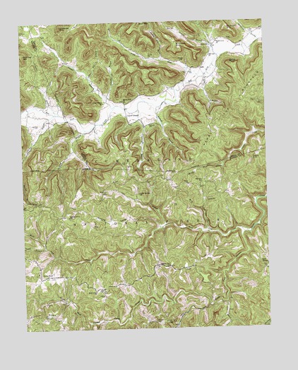
Alcorn, KY USGS Topographic Map
Click on map above to begin viewing in our Map Viewer.

This topographic map contains these locations and features:
Feature Name Type Latitude Longitude GNIS ID View Map
AlcornPopulated PlaceN37.5615°W84.0488°510225View Map
Alcorn Post OfficePost OfficeN37.5526°W84.0299°510227View Map
Barker CemeteryCemeteryN37.6179°W84.0177°510401View Map
Barker PointSummitN37.6079°W84.0174°510403View Map
Barker PointLocaleN37.6077°W84.0176°2440432View Map
Beaver Pond ChurchChurchN37.5929°W84.0713°510490View Map
Beech Grove Baptist ChurchChurchN37.6168°W84.0235°510523View Map
Bicknell (historical)Populated PlaceN37.5828°W84.0519°2440448View Map
Bicknell BranchStreamN37.5904°W84.0541°510590View Map
Bicknell SchoolSchoolN37.5832°W84.0595°510591View Map
Big HollowValleyN37.5402°W84.0307°510663View Map
Blanton FlatsPopulated PlaceN37.5701°W84.0038°510778View Map
BrazilPopulated PlaceN37.5248°W84.0416°510900View Map
Brazil Post Office (historical)Post OfficeN37.5244°W84.0415°2505043View Map
Brooks MountainSummitN37.6140°W84.0435°510940View Map
Campbell BranchStreamN37.5940°W84.0799°511161View Map
Cane BranchStreamN37.5423°W84.0516°511179View Map
Chestnut Flat (historical)Populated PlaceN37.5258°W84.0506°2505052View Map
Chestnut Flat SchoolSchoolN37.5254°W84.0502°511329View Map
Chrisman MountainSummitN37.6231°W84.1035°511359View Map
Combs CemeteryCemeteryN37.5137°W84.0841°511488View Map
Combs Post Office (historical)Post OfficeN37.6200°W84.1190°2557507View Map
Copperas BranchStreamN37.5879°W84.1069°511530View Map
Coyle CemeteryCemeteryN37.5242°W84.0008°511612View Map
Davis ChurchChurchN37.5590°W84.0396°511740View Map
Dry ForkStreamN37.5095°W84.0308°517055View Map
Dry Fork (historical)Populated PlaceN37.5080°W84.0381°2505072View Map
Dry Fork SchoolSchoolN37.5031°W84.0516°511933View Map
Durham RidgeRidgeN37.5065°W84.1177°511964View Map
Durham Ridge (historical)Populated PlaceN37.5063°W84.1123°2505015View Map
Fairview SchoolSchoolN37.5604°W84.0327°512115View Map
Garrett CemeteryCemeteryN37.6109°W84.0571°512283View Map
Garrett SchoolSchoolN37.6093°W84.0416°512284View Map
Grassy Springs ChurchChurchN37.5518°W84.1169°512394View Map
Gum CemeteryCemeteryN37.6204°W84.0058°512481View Map
Hade-Rose CemeteryCemeteryN37.5829°W84.1180°512499View Map
Happy Top (historical)Populated PlaceN37.5796°W84.0264°2440544View Map
Happy Top MountainSummitN37.5881°W84.0174°512558View Map
Happy Top Post Office (historical)Post OfficeN37.5777°W84.0244°2440482View Map
Harrison CemeteryCemeteryN37.5579°W84.0341°512573View Map
Henderson BranchStreamN37.6176°W84.0027°512647View Map
HiselPopulated PlaceN37.5556°W84.0838°512718View Map
Hisel Elementary SchoolSchoolN37.5526°W84.0844°516781View Map
Horns RiverStreamN37.6026°W84.0327°512788View Map
Indian Spring (historical)Populated PlaceN37.5554°W84.0664°2504906View Map
Indian Springs SchoolSchoolN37.5551°W84.0647°512916View Map
Isaacs CemeteryCemeteryN37.5420°W84.0883°512929View Map
Isaacs CemeteryCemeteryN37.6042°W84.0385°512930View Map
Jenkins BranchStreamN37.6112°W84.0233°512991View Map
JinksPopulated PlaceN37.6065°W84.0321°513014View Map
Jinks Post Office (historical)Post OfficeN37.6064°W84.0317°2440485View Map
Kerby KnobPopulated PlaceN37.5218°W84.1133°513131View Map
Kirby Knob Post Office (historical)Post OfficeN37.5220°W84.1127°2504909View Map
Kirby Knob School (historical)SchoolN37.5252°W84.1170°2504910View Map
Kissey BranchStreamN37.5895°W84.0641°513160View Map
Kissie HillSummitN37.5720°W84.0546°2440532View Map
Locust BranchPopulated PlaceN37.5862°W84.0697°513560View Map
Locust BranchStreamN37.5906°W84.0763°513561View Map
Locust Branch Post Office (historical)Post OfficeN37.5944°W84.0799°2440489View Map
Locust Branch SchoolSchoolN37.5920°W84.0819°513562View Map
Long BranchStreamN37.5812°W84.0919°513597View Map
Needmore CemeteryCemeteryN37.6204°W84.1238°514212View Map
Park (historical)Populated PlaceN37.6157°W84.0275°2440558View Map
Parks SchoolSchoolN37.6159°W84.0271°514441View Map
Powell BranchStreamN37.5334°W84.1144°514751View Map
Powell SchoolSchoolN37.5156°W84.0863°514753View Map
Powells MillLocaleN37.5132°W84.1152°2504948View Map
Red Lick ChurchChurchN37.6112°W84.0274°514871View Map
Reeves MountainSummitN37.6223°W84.0180°514880View Map
Rock Lick CreekStreamN37.5395°W84.0105°515033View Map
Rose CemeteryCemeteryN37.5509°W84.0471°515103View Map
Sand Gap Fire Department Station 2BuildingN37.5217°W84.1173°2637283View Map
Sang BranchStreamN37.6023°W84.0305°515247View Map
Shirley BranchStreamN37.5879°W84.1083°515362View Map
Sinking ValleyValleyN37.5418°W84.0548°515438View Map
Sinking Valley (historical)Populated PlaceN37.5460°W84.1020°2504963View Map
Sinking Valley SchoolSchoolN37.5459°W84.1010°515440View Map
Skinner CemeteryCemeteryN37.5598°W84.0608°515455View Map
South Fork ChurchChurchN37.5156°W84.0883°515540View Map
Spruce Pine BranchStreamN37.6026°W84.0885°515627View Map
Swine CemeteryCemeteryN37.6226°W84.0441°515839View Map
Turkey Pen BranchStreamN37.6093°W84.0510°516056View Map
Turtle RockPillarN37.5871°W84.1050°2557499View Map
Turtle Rock Store (historical)LocaleN37.5879°W84.1055°2557500View Map
Viney BottomBendN37.5054°W84.0216°516187View Map
Willis CemeteryCemeteryN37.5673°W84.0710°516387View Map
Wilson CemeteryCemeteryN37.5029°W84.0577°516400View Map

Note: Coordinates in the location and feature list above are referenced to NAD83 datum.


Copyright (C) 2008-2025 Ryan Niemi / Sunset Dynamics ... All Rights Reserved