TopoQuest Logo
Do you find TopoQuest useful?
Help keep TopoQuest running and adding new maps/features by donating!
Bitcoin:  19c7KJd3qBynnjoSw5npx9KScwjBe4ifkT
Litecoin:  LXs6TkuXGGXo1vDsWCkWVdjQX94eUKd6ui
Home View Maps Find Maps Find Places Resources & Links


McLeod Basin, Montana Topographic Map

USGS Map Title: McLeod Basin, MT
USGS Map MRC: 45110E2
DRG (GeoTIFF) Download: o45110e2.tif


Neighboring USGS Topographic Map Quads:


  Elton, MT  
45110F3
 

  Springdale, MT  
45110F2
 

  McLeod, MT  
45110F1
 

  Mount Rae, MT  
45110E3
 

  McLeod Basin, MT  
45110E2
 

  Enos Mountain, MT  
45110E1
 

  West Boulder Plateau, MT  
45110D3
 

  Chrome Mountain, MT  
45110D2
 

  Picket Pin Mountain, MT  
45110D1


Map MRC Location:

N46°
W111°
N46°
W110°
H8 H7 H6 H5 H4 H3 H2 H1
G8 G7 G6 G5 G4 G3 G2 G1
F8 F7 F6 F5 F4 F3 F2 F1
E8 E7 E6 E5 E4 E3 E2 E1
D8 D7 D6 D5 D4 D3 D2 D1
C8 C7 C6 C5 C4 C3 C2 C1
B8 B7 B6 B5 B4 B3 B2 B1
A8 A7 A6 A5 A4 A3 A2 A1
N45°
W111°
N45°
W110°

McLeod Basin, MT USGS 1:24K Topographic Map Preview:
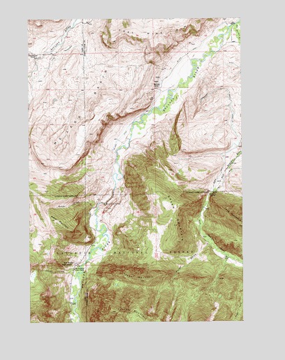
McLeod Basin, MT USGS Topographic Map
Click on map above to begin viewing in our Map Viewer.

This topographic map contains these locations and features:
Feature Name Type Latitude Longitude GNIS ID View Map
02S13E33CDAD01 WellWellN45.6138°W110.1266°810545View Map
03S12E12DACA01 WellWellN45.5863°W110.1799°810278View Map
03S12E13BCDA01 WellWellN45.5755°W110.1921°810228View Map
03S12E13CBBA01 WellWellN45.5738°W110.1946°810218View Map
03S13E05BACD01 WellWellN45.6077°W110.1499°810475View Map
03S13E05CBBB01 WellWellN45.6030°W110.1555°810435View Map
03S13E07BABD01 WellWellN45.5947°W110.1707°810364View Map
03S13E21BABB01 SpringSpringN45.5672°W110.1291°810162View Map
03S13E21BCBA01 SpringSpringN45.5638°W110.1335°810141View Map
03S13E29ABAB01 SpringSpringN45.5531°W110.1429°810091View Map
04S13E05ADBD01 SpringSpringN45.5175°W110.1399°809920View Map
Anderson SpringsSpringN45.5533°W110.1444°779041View Map
Baker DrawValleyN45.5610°W110.2016°779268View Map
Baker MountainSummitN45.5422°W110.2357°779272View Map
Coal Mine RimRidgeN45.6222°W110.1769°781456View Map
ContactPopulated PlaceN45.5083°W110.2260°781593View Map
Contact CreekStreamN45.5194°W110.2235°781595View Map
Contact Post Office (historical)Post OfficeN45.5083°W110.2260°1743318View Map
Contact School (historical)SchoolN45.5083°W110.2260°1743265View Map
East Boulder CampgroundLocaleN45.5369°W110.1499°794447View Map
East Boulder RiverStreamN45.6235°W110.1266°782782View Map
Fuller GulchValleyN45.5319°W110.1460°783785View Map
Green MountainRidgeN45.5497°W110.1696°784288View Map
Hubble Post Office (historical)Post OfficeN45.5527°W110.1452°1743430View Map
Main Boulder Ranger StationLocaleN45.5238°W110.2257°786791View Map
Mason DitchCanalN45.5785°W110.1299°786912View Map
McLeod BasinBasinN45.5913°W110.2149°787101View Map
McLeod DitchCanalN45.5919°W110.1760°787102View Map
McLeod SchoolSchoolN45.5977°W110.1735°787106View Map
Natural Bridge DrawValleyN45.5472°W110.2110°793910View Map
Natural Bridge Point of InterestLocaleN45.5477°W110.2055°794446View Map
Natural Bridge State ParkParkN45.5491°W110.2063°1743473View Map
Old Kaintuck Guest RanchLocaleN45.5219°W110.2246°788417View Map
Tepee MountainSummitN45.5169°W110.1832°791992View Map

Note: Coordinates in the location and feature list above are referenced to NAD83 datum.


Copyright (C) 2008-2025 Ryan Niemi / Sunset Dynamics ... All Rights Reserved