TopoQuest Logo
Do you find TopoQuest useful?
Help keep TopoQuest running and adding new maps/features by donating!
Bitcoin:  19c7KJd3qBynnjoSw5npx9KScwjBe4ifkT
Litecoin:  LXs6TkuXGGXo1vDsWCkWVdjQX94eUKd6ui
Home View Maps Find Maps Find Places Resources & Links


Springdale, Montana Topographic Map

USGS Map Title: Springdale, MT
USGS Map MRC: 45110F2
DRG (GeoTIFF) Download: o45110f2.tif


Neighboring USGS Topographic Map Quads:


  Hunters Hot Springs, MT  
45110G3
 

  Kelly Hills, MT  
45110G2
 

  Carney, MT  
45110G1
 

  Elton, MT  
45110F3
 

  Springdale, MT  
45110F2
 

  McLeod, MT  
45110F1
 

  Mount Rae, MT  
45110E3
 

  McLeod Basin, MT  
45110E2
 

  Enos Mountain, MT  
45110E1


Map MRC Location:

N46°
W111°
N46°
W110°
H8 H7 H6 H5 H4 H3 H2 H1
G8 G7 G6 G5 G4 G3 G2 G1
F8 F7 F6 F5 F4 F3 F2 F1
E8 E7 E6 E5 E4 E3 E2 E1
D8 D7 D6 D5 D4 D3 D2 D1
C8 C7 C6 C5 C4 C3 C2 C1
B8 B7 B6 B5 B4 B3 B2 B1
A8 A7 A6 A5 A4 A3 A2 A1
N45°
W111°
N45°
W110°

Springdale, MT USGS 1:24K Topographic Map Preview:
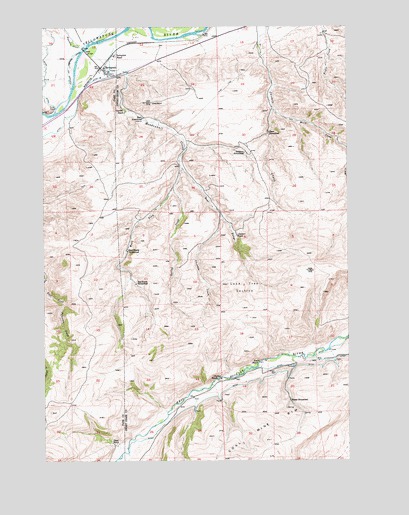
Springdale, MT USGS Topographic Map
Click on map above to begin viewing in our Map Viewer.

This topographic map contains these locations and features:
Feature Name Type Latitude Longitude GNIS ID View Map
01S12E22A___03 WellWellN45.7374°W110.2255°811546View Map
01S12E22C___01 WellWellN45.7299°W110.2357°811482View Map
01S12E23ACBD01 WellWellN45.7355°W110.2071°811533View Map
01S13E18DDDB01 SpringSpringN45.7422°W110.1605°811587View Map
02S13E20ABBA01 WellWellN45.6533°W110.1477°810833View Map
Bert Woods HomesteadLocaleN45.6755°W110.2124°768728View Map
Bob Woods HomesteadLocaleN45.6755°W110.2124°769061View Map
Calcite MineMineN45.7277°W110.2077°805378View Map
Chicken CreekStreamN45.6952°W110.1774°769814View Map
Clayton RanchLocaleN45.6483°W110.1791°769917View Map
Currier RanchLocaleN45.7258°W110.2169°770379View Map
East Fork Mendenhall CreekStreamN45.7088°W110.1938°771053View Map
Elgas RanchLocaleN45.6299°W110.2207°771174View Map
Foster RanchLocaleN45.6530°W110.1613°771540View Map
Hash HomesteadLocaleN45.7238°W110.2096°772193View Map
Hunters CreekStreamN45.7438°W110.2338°772638View Map
Interchange 352CrossingN45.7249°W110.2424°1743085View Map
Interchange 354CrossingN45.7366°W110.2174°1743476View Map
Jarrett RanchLocaleN45.6899°W110.1713°772795View Map
Lone Tree SectionLocaleN45.6758°W110.1682°773613View Map
Mason HomesteadLocaleN45.6416°W110.1488°773918View Map
Mendenhall CreekStreamN45.7455°W110.2274°774106View Map
Olson HomesteadLocaleN45.7197°W110.1577°774965View Map
Spring CreekStreamN45.7035°W110.1971°776998View Map
SpringdalePopulated PlaceN45.7383°W110.2271°777090View Map
Springdale (historical)LocaleN45.7383°W110.2271°1743324View Map
Springdale BridgeBridgeN45.7435°W110.2333°1743079View Map
Springdale Bridge Fishing Access SiteLocaleN45.7424°W110.2321°1744485View Map
Springdale Census Designated PlaceCensusN45.7381°W110.2235°2583850View Map
Springdale Post Office (historical)Post OfficeN45.7364°W110.2237°1743325View Map
Springdale RanchLocaleN45.7419°W110.2207°777091View Map
Springdale SchoolSchoolN45.7364°W110.2237°1743280View Map
Swanson HomesteadLocaleN45.7135°W110.1669°777352View Map
West Fork Mendenhall CreekStreamN45.7088°W110.1941°778255View Map
Wild CreekStreamN45.7263°W110.1557°793284View Map

Note: Coordinates in the location and feature list above are referenced to NAD83 datum.


Copyright (C) 2008-2025 Ryan Niemi / Sunset Dynamics ... All Rights Reserved