TopoQuest Logo
Do you find TopoQuest useful?
Help keep TopoQuest running and adding new maps/features by donating!
Bitcoin:  19c7KJd3qBynnjoSw5npx9KScwjBe4ifkT
Litecoin:  LXs6TkuXGGXo1vDsWCkWVdjQX94eUKd6ui
Home View Maps Find Maps Find Places Resources & Links


McNab, Arkansas Topographic Map

USGS Map Title: McNab, AR
USGS Map MRC: 33093F7
DRG (GeoTIFF) Download: o33093f7.tif


Neighboring USGS Topographic Map Quads:


  Mineral Springs South, AR  
33093G8
 

  Columbus, AR  
33093G7
 

  Washington, AR  
33093G6
 

  Red Bluff, AR  
33093F8
 

  McNab, AR  
33093F7
 

  Sheppard, AR  
33093F6
 

  Homan, AR  
33093E8
 

  Fulton, AR  
33093E7
 

  Spring Hill, AR  
33093E6


Map MRC Location:

N34°
W94°
N34°
W93°
H8 H7 H6 H5 H4 H3 H2 H1
G8 G7 G6 G5 G4 G3 G2 G1
F8 F7 F6 F5 F4 F3 F2 F1
E8 E7 E6 E5 E4 E3 E2 E1
D8 D7 D6 D5 D4 D3 D2 D1
C8 C7 C6 C5 C4 C3 C2 C1
B8 B7 B6 B5 B4 B3 B2 B1
A8 A7 A6 A5 A4 A3 A2 A1
N33°
W94°
N33°
W93°

McNab, AR USGS 1:24K Topographic Map Preview:
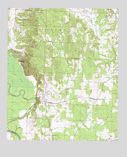
McNab, AR USGS Topographic Map
Click on map above to begin viewing in our Map Viewer.

This topographic map contains these locations and features:
Feature Name Type Latitude Longitude GNIS ID View Map
Camp SpringLocaleN33.7460°W93.8410°47334View Map
Church Hill ChurchChurchN33.7026°W93.7943°47781View Map
Douglas SchoolSchoolN33.6690°W93.8313°48587View Map
Gibson CreekStreamN33.6968°W93.7599°49398View Map
Grassy LakeSwampN33.6887°W93.8693°49578View Map
Gravel Hill ChurchChurchN33.6679°W93.8341°49586View Map
Hempstead Country Hunting ClubLocaleN33.6993°W93.8610°82442View Map
John W Turk Jr Power PlantLocaleN33.6511°W93.8117°2740750View Map
Little Bridge CreekStreamN33.6690°W93.8202°61481View Map
Mars Hill ChurchChurchN33.7310°W93.7585°77600View Map
McNabPopulated PlaceN33.6612°W93.8327°51870View Map
Mount Pleasant ChurchChurchN33.6640°W93.7735°52394View Map
Thrasher (historical)Populated PlaceN33.6612°W93.8141°61480View Map
Town of McNabCivilN33.6614°W93.8318°2406138View Map
Township of Bois d'ArcCivilN33.6309°W93.8151°66640View Map
Township of SalineCivilN33.7264°W93.8599°66647View Map
Turkey CreekStreamN33.6379°W93.7802°55713View Map
Whitehouse CemeteryCemeteryN33.6821°W93.8010°56319View Map
Yellow Creek ChurchChurchN33.7379°W93.8580°56599View Map
Zion Hill ChurchChurchN33.6298°W93.8235°56641View Map

Note: Coordinates in the location and feature list above are referenced to NAD83 datum.


Copyright (C) 2008-2024 Ryan Niemi / Sunset Dynamics ... All Rights Reserved