TopoQuest Logo
Do you find TopoQuest useful?
Help keep TopoQuest running and adding new maps/features by donating!
Bitcoin:  19c7KJd3qBynnjoSw5npx9KScwjBe4ifkT
Litecoin:  LXs6TkuXGGXo1vDsWCkWVdjQX94eUKd6ui
Home View Maps Find Maps Find Places Resources & Links


Millers Station, Pennsylvania Topographic Map

USGS Map Title: Millers Station, PA
USGS Map MRC: 41079G8
DRG (GeoTIFF) Download: o41079g8.tif


Neighboring USGS Topographic Map Quads:


  Cambridge Springs NE, PA  
41080H1
 

  Waterford, PA  
41079H8
 

  Union City, PA  
41079H7
 

  Cambridge Springs, PA  
41080G1
 

  Millers Station, PA  
41079G8
 

  Lake Canadohta, PA  
41079G7
 

  Blooming Valley, PA  
41080F1
 

  Townville, PA  
41079F8
 

  Centerville, PA  
41079F7


Map MRC Location:

N42°
W80°
N42°
W79°
H8 H7 H6 H5 H4 H3 H2 H1
G8 G7 G6 G5 G4 G3 G2 G1
F8 F7 F6 F5 F4 F3 F2 F1
E8 E7 E6 E5 E4 E3 E2 E1
D8 D7 D6 D5 D4 D3 D2 D1
C8 C7 C6 C5 C4 C3 C2 C1
B8 B7 B6 B5 B4 B3 B2 B1
A8 A7 A6 A5 A4 A3 A2 A1
N41°
W80°
N41°
W79°

Millers Station, PA USGS 1:24K Topographic Map Preview:
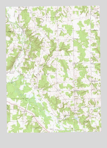
Millers Station, PA USGS Topographic Map
Click on map above to begin viewing in our Map Viewer.

This topographic map contains these locations and features:
Feature Name Type Latitude Longitude GNIS ID View Map
Asbury CemeteryCemeteryN41.8682°W79.8840°2712270View Map
Brown HillPopulated PlaceN41.7909°W79.9323°1170366View Map
Camp MysticLocaleN41.8639°W79.9981°1171060View Map
Campbell RunStreamN41.8409°W79.9795°1171138View Map
Chapinville CemeteryCemeteryN41.8185°W79.9110°1171566View Map
Crabs CornersLocaleN41.7714°W79.9098°1172584View Map
Dead CreekStreamN41.7862°W79.9798°1173021View Map
Dobbs SchoolSchoolN41.7659°W79.8801°1205395View Map
Eaton CornersLocaleN41.7642°W79.9328°1173937View Map
Everwind RanchLocaleN41.8553°W79.9072°2712276View Map
Ferris CornersPopulated PlaceN41.7942°W79.9623°1174712View Map
Forest Home CornersLocaleN41.8006°W79.8864°1174974View Map
Foxburg CornersLocaleN41.7856°W79.9539°1205396View Map
Glover CornersLocaleN41.7914°W79.9095°1175758View Map
Hinkley CornersLocaleN41.8706°W79.8792°1177138View Map
Horton SchoolSchoolN41.8676°W79.8864°1205400View Map
Jervis ChurchChurchN41.7662°W79.9631°1178071View Map
Jervis CornersLocaleN41.7714°W79.9737°1178072View Map
Kelly RunStreamN41.8067°W79.9842°1178338View Map
Kings CornersLocaleN41.8181°W79.8873°1178489View Map
Little Federal RunStreamN41.7689°W79.8912°1179542View Map
Mackey HillSummitN41.8426°W79.9434°1180156View Map
Mackey Hill CemeteryCemeteryN41.8545°W79.9566°1180157View Map
Mackey Hill ChurchChurchN41.8387°W79.9476°1180158View Map
Mackey RunStreamN41.7548°W79.9259°1180160View Map
Millers StationPopulated PlaceN41.8106°W79.9945°1181253View Map
Muddy CreekStreamN41.8003°W79.9937°1182045View Map
Oberlander AirportAirportN41.8593°W79.9074°2443630View Map
Pleasant HillSummitN41.8181°W79.9126°1184027View Map
Rockdale AcresPopulated PlaceN41.7670°W79.9237°1185303View Map
Rockdale Center High SchoolSchoolN41.8045°W79.9751°1205397View Map
Rocky Top FarmLocaleN41.8500°W79.9592°2711793View Map
Spring LakeLakeN41.7637°W79.9078°1188240View Map
State Game Lands Number 85ParkN41.7859°W79.9862°1188537View Map
Sturgis CornersLocaleN41.8426°W79.9098°1188912View Map
TeeplevillePopulated PlaceN41.7526°W79.9381°1189339View Map
Township of RockdaleCivilN41.8043°W79.9680°1216313View Map
Troyer DamDamN41.7584°W79.9048°1195784View Map
Weston SchoolSchoolN41.8578°W79.9928°1205398View Map
Wilkins ChurchChurchN41.8284°W79.8864°1191438View Map
Willey School (historical)SchoolN41.8609°W79.9106°1205399View Map

Note: Coordinates in the location and feature list above are referenced to NAD83 datum.


Copyright (C) 2008-2025 Ryan Niemi / Sunset Dynamics ... All Rights Reserved