TopoQuest Logo
Do you find TopoQuest useful?
Help keep TopoQuest running and adding new maps/features by donating!
Bitcoin:  19c7KJd3qBynnjoSw5npx9KScwjBe4ifkT
Litecoin:  LXs6TkuXGGXo1vDsWCkWVdjQX94eUKd6ui
Home View Maps Find Maps Find Places Resources & Links


Townville, Pennsylvania Topographic Map

USGS Map Title: Townville, PA
USGS Map MRC: 41079F8
DRG (GeoTIFF) Download: o41079f8.tif


Neighboring USGS Topographic Map Quads:


  Cambridge Springs, PA  
41080G1
 

  Millers Station, PA  
41079G8
 

  Lake Canadohta, PA  
41079G7
 

  Blooming Valley, PA  
41080F1
 

  Townville, PA  
41079F8
 

  Centerville, PA  
41079F7
 

  Cochranton, PA  
41080E1
 

  Sugar Lake, PA  
41079E8
 

  Dempseytown, PA  
41079E7


Map MRC Location:

N42°
W80°
N42°
W79°
H8 H7 H6 H5 H4 H3 H2 H1
G8 G7 G6 G5 G4 G3 G2 G1
F8 F7 F6 F5 F4 F3 F2 F1
E8 E7 E6 E5 E4 E3 E2 E1
D8 D7 D6 D5 D4 D3 D2 D1
C8 C7 C6 C5 C4 C3 C2 C1
B8 B7 B6 B5 B4 B3 B2 B1
A8 A7 A6 A5 A4 A3 A2 A1
N41°
W80°
N41°
W79°

Townville, PA USGS 1:24K Topographic Map Preview:
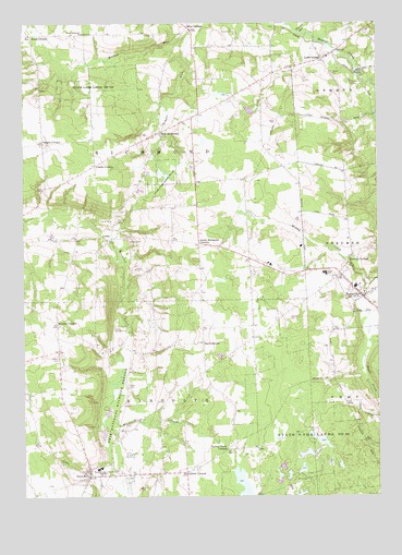
Townville, PA USGS Topographic Map
Click on map above to begin viewing in our Map Viewer.

This topographic map contains these locations and features:
Feature Name Type Latitude Longitude GNIS ID View Map
Barlow School (historical)SchoolN41.7237°W79.8862°1200990View Map
Basil CornersLocaleN41.6656°W79.9364°1168794View Map
Borough of TownvilleCivilN41.6791°W79.8801°1215143View Map
Buckley CornersLocaleN41.6881°W79.8834°1170572View Map
Center School (historical)SchoolN41.6581°W79.9356°1200984View Map
Clarks CornersLocaleN41.7128°W79.9742°1171927View Map
Federal RunStreamN41.7476°W79.9020°1174656View Map
Gilbert CornersLocaleN41.6314°W79.9428°1175601View Map
Guys MillsPopulated PlaceN41.6301°W79.9776°1176333View Map
Guys Mills Census Designated PlaceCensusN41.6308°W79.9759°2389888View Map
Guys Mills Post OfficePost OfficeN41.6318°W79.9765°2779738View Map
Hatch CemeteryCemeteryN41.6617°W79.9877°1176642View Map
Hatch SchoolSchoolN41.6612°W79.9873°1200985View Map
Hickory CornersLocaleN41.6709°W79.9884°1176950View Map
Higby School (historical)SchoolN41.6728°W79.8912°1200983View Map
Jewel CornersLocaleN41.7470°W79.9967°1178075View Map
Lamb SchoolSchoolN41.6973°W79.8903°1200982View Map
Little CooleyPopulated PlaceN41.7406°W79.8939°1179511View Map
LyonaPopulated PlaceN41.6934°W79.9681°1204082View Map
Miles CornersLocaleN41.7481°W79.9406°1181100View Map
New RichmondPopulated PlaceN41.7214°W79.9512°1182362View Map
North Richmond ChurchChurchN41.7476°W79.9787°1182625View Map
Oregon CornersLocaleN41.7184°W79.9926°1183036View Map
Randolph Volunteer Fire Department 18BuildingN41.6307°W79.9773°2645831View Map
Randolph-East Mead High SchoolSchoolN41.6328°W79.9734°1184646View Map
Root SchoolSchoolN41.7476°W79.9659°1200986View Map
Sayre School (historical)SchoolN41.7123°W79.9084°1200981View Map
Smith CemeteryCemeteryN41.7339°W79.8835°1187859View Map
South Richmond CornersLocaleN41.6920°W79.9376°1188104View Map
South Richmond SchoolSchoolN41.6909°W79.9373°1200977View Map
State Game Lands Number 146ParkN41.7334°W79.9664°1208041View Map
State Game Lands Number 200ParkN41.7084°W79.9498°1208040View Map
State Game Lands Number 69ParkN41.6395°W79.9006°1188526View Map
Temple RunStreamN41.7481°W79.9406°1193518View Map
Township of RandolphCivilN41.6292°W79.9542°1216311View Map
Township of RichmondCivilN41.7185°W79.9647°1216312View Map
TownvillePopulated PlaceN41.6778°W79.8798°1189705View Map
Townville Post OfficePost OfficeN41.6785°W79.8806°2779706View Map
Townville Volunteer Fire Department 24BuildingN41.6777°W79.8806°2644890View Map
Turkey Track CornersLocaleN41.6376°W79.9281°1189951View Map
Union CemeteryCemeteryN41.6314°W79.9679°1190116View Map

Note: Coordinates in the location and feature list above are referenced to NAD83 datum.


Copyright (C) 2008-2025 Ryan Niemi / Sunset Dynamics ... All Rights Reserved