TopoQuest Logo
Do you find TopoQuest useful?
Help keep TopoQuest running and adding new maps/features by donating!
Bitcoin:  19c7KJd3qBynnjoSw5npx9KScwjBe4ifkT
Litecoin:  LXs6TkuXGGXo1vDsWCkWVdjQX94eUKd6ui
Home View Maps Find Maps Find Places Resources & Links


Millerville, Minnesota Topographic Map

USGS Map Title: Millerville, MN
USGS Map MRC: 46095A5
DRG (GeoTIFF) Download: o46095a5.tif


Neighboring USGS Topographic Map Quads:


  Eagle Lake, MN  
46095B6
 

  Inspiration Peak, MN  
46095B5
 

  Parkers Prairie NW, MN  
46095B4
 

  Evansville, MN  
46095A6
 

  Millerville, MN  
46095A5
 

  Lake Miltona West, MN  
46095A4
 

  Quam Lake, MN  
45095H6
 

  Brandon, MN  
45095H5
 

  Alexandria West, MN  
45095H4


Map MRC Location:

N47°
W96°
N47°
W95°
H8 H7 H6 H5 H4 H3 H2 H1
G8 G7 G6 G5 G4 G3 G2 G1
F8 F7 F6 F5 F4 F3 F2 F1
E8 E7 E6 E5 E4 E3 E2 E1
D8 D7 D6 D5 D4 D3 D2 D1
C8 C7 C6 C5 C4 C3 C2 C1
B8 B7 B6 B5 B4 B3 B2 B1
A8 A7 A6 A5 A4 A3 A2 A1
N46°
W96°
N46°
W95°

Millerville, MN USGS 1:24K Topographic Map Preview:
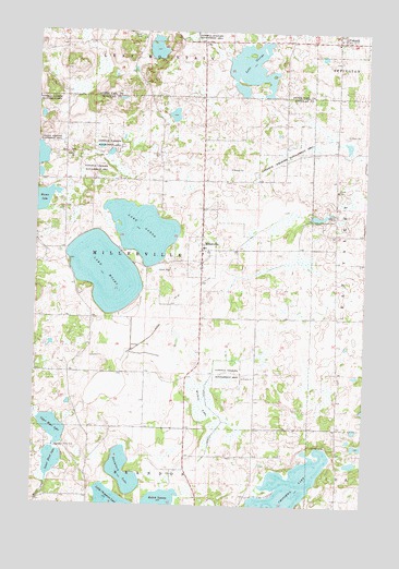
Millerville, MN USGS Topographic Map
Click on map above to begin viewing in our Map Viewer.

This topographic map contains these locations and features:
Feature Name Type Latitude Longitude GNIS ID View Map
Anderson LakeReservoirN46.0716°W95.6220°1777069View Map
Anderson Lake DamDamN46.0716°W95.6203°1777068View Map
Baumbach LakeLakeN46.0090°W95.5905°639735View Map
Boesen LakeLakeN46.0803°W95.6231°640325View Map
City of MillervilleCivilN46.0691°W95.5570°2395330View Map
City of UrbankCivilN46.1245°W95.5110°2397101View Map
County Ditch Number FourteenCanalN46.0325°W95.5595°641679View Map
County Ditch Number SixtyCanalN46.0486°W95.5762°642231View Map
Lake AaronLakeN46.0724°W95.5847°639180View Map
Lake GeorgeLakeN46.1159°W95.5447°644083View Map
Lake MosesLakeN46.0613°W95.5990°648128View Map
Lower Hunt LakeLakeN46.0114°W95.6177°647253View Map
MillervillePopulated PlaceN46.0675°W95.5625°647885View Map
Millerville CemeteryCemeteryN46.0703°W95.5611°2069671View Map
Millerville Fire DepartmentBuildingN46.0649°W95.5626°2666221View Map
Millerville Post Office (historical)Post OfficeN46.0675°W95.5622°2069739View Map
Millerville Sportsman Group Wildlife Structure DamDamN46.0850°W95.5837°1777090View Map
Pine Ridge Golf CourseLocaleN46.0411°W95.6083°2069786View Map
Redick SwampLakeN46.0010°W95.5765°649896View Map
Sacred Heart Catholic ChurchChurchN46.1233°W95.5111°2072791View Map
Sacred Heart Catholic Church CemeteryCemeteryN46.1233°W95.5103°2072792View Map
Township of MillervilleCivilN46.0639°W95.5834°664975View Map
Trinity CemeteryCemeteryN46.0928°W95.6125°2069672View Map
Trinity ChurchChurchN46.0925°W95.6123°653316View Map
Upper Hunt LakeLakeN46.0202°W95.6178°653550View Map
Upper Hunt LakeReservoirN46.0150°W95.6187°1776193View Map
Upper Hunt Lake DamDamN46.0150°W95.6187°1776192View Map
UrbankPopulated PlaceN46.1227°W95.5120°653577View Map
Urbank Post Office (historical)Post OfficeN46.1228°W95.5117°2072969View Map
Wilken LakeSwampN46.0264°W95.5612°654154View Map

Note: Coordinates in the location and feature list above are referenced to NAD83 datum.


Copyright (C) 2008-2025 Ryan Niemi / Sunset Dynamics ... All Rights Reserved