TopoQuest Logo
Do you find TopoQuest useful?
Help keep TopoQuest running and adding new maps/features by donating!
Bitcoin:  19c7KJd3qBynnjoSw5npx9KScwjBe4ifkT
Litecoin:  LXs6TkuXGGXo1vDsWCkWVdjQX94eUKd6ui
Home View Maps Find Maps Find Places Resources & Links


Brandon, Minnesota Topographic Map

USGS Map Title: Brandon, MN
USGS Map MRC: 45095H5
DRG (GeoTIFF) Download: o45095h5.tif


Neighboring USGS Topographic Map Quads:


  Evansville, MN  
46095A6
 

  Millerville, MN  
46095A5
 

  Lake Miltona West, MN  
46095A4
 

  Quam Lake, MN  
45095H6
 

  Brandon, MN  
45095H5
 

  Alexandria West, MN  
45095H4
 

  Kensington, MN  
45095G6
 

  Farwell, MN  
45095G5
 

  Lake Mary, MN  
45095G4


Map MRC Location:

N46°
W96°
N46°
W95°
H8 H7 H6 H5 H4 H3 H2 H1
G8 G7 G6 G5 G4 G3 G2 G1
F8 F7 F6 F5 F4 F3 F2 F1
E8 E7 E6 E5 E4 E3 E2 E1
D8 D7 D6 D5 D4 D3 D2 D1
C8 C7 C6 C5 C4 C3 C2 C1
B8 B7 B6 B5 B4 B3 B2 B1
A8 A7 A6 A5 A4 A3 A2 A1
N45°
W96°
N45°
W95°

Brandon, MN USGS 1:24K Topographic Map Preview:
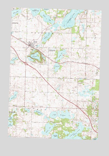
Brandon, MN USGS Topographic Map
Click on map above to begin viewing in our Map Viewer.

This topographic map contains these locations and features:
Feature Name Type Latitude Longitude GNIS ID View Map
Acorn Acres Resort and CampgroundLocaleN45.9958°W95.5556°2069713View Map
Aldrich LakeReservoirN45.9559°W95.5554°639267View Map
Angen FieldAirportN45.9363°W95.5262°2676845View Map
BrandonPopulated PlaceN45.9652°W95.5987°640435View Map
Brandon (historical)LocaleN45.9639°W95.5986°2069708View Map
Brandon AuditoriumBuildingN45.9647°W95.5964°2069711View Map
Brandon CemeteryCemeteryN45.9702°W95.6131°640436View Map
Brandon Fire DepartmentBuildingN45.9644°W95.5975°2069712View Map
Brandon High SchoolSchoolN45.9672°W95.5997°2069716View Map
Brandon Police DepartmentBuildingN45.9643°W95.5988°2069710View Map
Brandon Post OfficePost OfficeN45.9642°W95.5967°2069709View Map
Brown LakeLakeN45.8930°W95.6222°640534View Map
Burrs LakeLakeN45.9825°W95.5253°640683View Map
Chippewa CemeteryCemeteryN45.9480°W95.5936°641163View Map
Chippewa LakeLakeN45.9972°W95.5363°641165View Map
City of BrandonCivilN45.9663°W95.5945°2394239View Map
Devils LakeLakeN45.9908°W95.5763°642785View Map
East Moe CemeteryCemeteryN45.9292°W95.5300°2069668View Map
East Moe ChurchChurchN45.9291°W95.5298°643095View Map
Elizabeth LakeLakeN45.8998°W95.5831°643255View Map
Elk LakeLakeN45.9192°W95.5220°643261View Map
Gilbert LakeLakeN45.8840°W95.5705°644127View Map
Golden PondLakeN45.9536°W95.5800°648270View Map
Grace Lutheran ChurchChurchN45.9658°W95.5983°2069714View Map
Hoplin CreekStreamN45.9955°W95.6128°645187View Map
Interchange 90CrossingN45.9467°W95.6031°2069846View Map
Lake WilliamsLakeN45.8983°W95.5479°654172View Map
Little Chippewa LakeLakeN45.9988°W95.5939°646781View Map
Lobster LakeLakeN45.8759°W95.5253°646979View Map
Loves LakeLakeN45.9585°W95.5934°647239View Map
Martin LakeLakeN45.9017°W95.5983°2126996View Map
Minister LakeReservoirN45.9146°W95.6188°1776195View Map
Moe Heights CemeteryCemeteryN45.8753°W95.5934°648007View Map
Moon LakeLakeN45.9537°W95.5900°648056View Map
Nelson LakeLakeN45.9440°W95.5604°648455View Map
Oak Park CampgroundLocaleN45.9042°W95.5153°2069698View Map
Saint Ann's ChurchChurchN45.9661°W95.5942°2069715View Map
Township of BrandonCivilN45.9770°W95.5825°663652View Map
Township of MoeCivilN45.8901°W95.5720°665005View Map
West Moe CemeteryCemeteryN45.9055°W95.6139°2069669View Map
West Moe ChurchChurchN45.9058°W95.6148°653988View Map
Whiskey LakeLakeN45.9729°W95.5756°654070View Map
Wolf CreekStreamN45.9980°W95.6209°654304View Map

Note: Coordinates in the location and feature list above are referenced to NAD83 datum.


Copyright (C) 2008-2025 Ryan Niemi / Sunset Dynamics ... All Rights Reserved