TopoQuest Logo
Do you find TopoQuest useful?
Help keep TopoQuest running and adding new maps/features by donating!
Bitcoin:  19c7KJd3qBynnjoSw5npx9KScwjBe4ifkT
Litecoin:  LXs6TkuXGGXo1vDsWCkWVdjQX94eUKd6ui
Home View Maps Find Maps Find Places Resources & Links


Nashville, Arkansas Topographic Map

USGS Map Title: Nashville, AR
USGS Map MRC: 33093H7
DRG (GeoTIFF) Download: o33093h7.tif


Neighboring USGS Topographic Map Quads:


  Center Point, AR  
34093A8
 

  Nathan, AR  
34093A7
 

  Murfreesboro, AR  
34093A6
 

  Mineral Springs North, AR  
33093H8
 

  Nashville, AR  
33093H7
 

  McCaskill, AR  
33093H6
 

  Mineral Springs South, AR  
33093G8
 

  Columbus, AR  
33093G7
 

  Washington, AR  
33093G6


Map MRC Location:

N34°
W94°
N34°
W93°
H8 H7 H6 H5 H4 H3 H2 H1
G8 G7 G6 G5 G4 G3 G2 G1
F8 F7 F6 F5 F4 F3 F2 F1
E8 E7 E6 E5 E4 E3 E2 E1
D8 D7 D6 D5 D4 D3 D2 D1
C8 C7 C6 C5 C4 C3 C2 C1
B8 B7 B6 B5 B4 B3 B2 B1
A8 A7 A6 A5 A4 A3 A2 A1
N33°
W94°
N33°
W93°

Nashville, AR USGS 1:24K Topographic Map Preview:
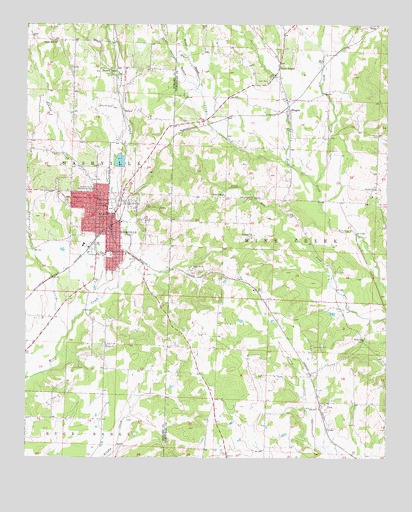
Nashville, AR USGS Topographic Map
Click on map above to begin viewing in our Map Viewer.

This topographic map contains these locations and features:
Feature Name Type Latitude Longitude GNIS ID View Map
Amity Church (historical)ChurchN33.9276°W93.8719°62519View Map
Antioch ChurchChurchN33.9296°W93.8177°45896View Map
BellairPopulated PlaceN33.9001°W93.7741°61419View Map
BingenPopulated PlaceN33.9757°W93.7841°57380View Map
Bingen Volunteer Fire DepartmentBuildingN33.9766°W93.7841°2116152View Map
Bryant BranchStreamN33.9807°W93.8155°47099View Map
Cary CreekStreamN33.9604°W93.7855°47507View Map
Chapel HillPopulated PlaceN33.9954°W93.8655°62555View Map
Chapel Hill ChurchChurchN33.9951°W93.8652°47698View Map
Chapel Hill School (historical)SchoolN33.9976°W93.8666°62556View Map
City of NashvilleCivilN33.9412°W93.8520°2404349View Map
ClowPopulated PlaceN33.8898°W93.7727°57559View Map
Coleys ChapelChurchN33.9507°W93.8068°47922View Map
Compton (historical)Populated PlaceN33.9265°W93.8018°61422View Map
Cummings CemeteryCemeteryN33.9073°W93.7757°48259View Map
Dodson CreekStreamN33.9504°W93.8435°76807View Map
DoylePopulated PlaceN33.9529°W93.7538°61421View Map
Doyle ChurchChurchN33.9526°W93.7543°48597View Map
Fair Acre School (historical)SchoolN33.8790°W93.8485°62577View Map
First Christian ChurchChurchN33.9487°W93.8469°62580View Map
First Presbyterian ChurchChurchN33.9426°W93.8482°62581View Map
Holt CreekStreamN33.9540°W93.7752°50267View Map
Howard County AirportAirportN33.9957°W93.8394°83794View Map
Howard County AmbulanceBuildingN33.9418°W93.8482°2119058View Map
Howard County CourthouseBuildingN33.9479°W93.8477°62603View Map
Howard County Sheriff's OfficeBuildingN33.9478°W93.8457°2118969View Map
Howard Memorial HospitalHospitalN33.9527°W93.8572°77245View Map
KBHC-AM (Nashville)TowerN33.9293°W93.8505°85326View Map
KNAS-FM (Nashville)TowerN33.9293°W93.8505°85411View Map
Lake NickelsReservoirN33.9607°W93.8428°80665View Map
Lake Nickels DamDamN33.9584°W93.8419°80664View Map
NashvillePopulated PlaceN33.9457°W93.8471°77792View Map
Nashville CemeteryCemeteryN33.9501°W93.8452°62629View Map
Nashville Elementary SchoolSchoolN33.9557°W93.8481°62630View Map
Nashville High SchoolSchoolN33.9560°W93.8519°2039312View Map
Nashville Junior High SchoolSchoolN33.9541°W93.8543°2039311View Map
Nashville Police DepartmentBuildingN33.9473°W93.8468°2118968View Map
Nashville Post OfficePost OfficeN33.9454°W93.8471°84217View Map
Nashville Primary SchoolSchoolN33.9570°W93.8565°2039313View Map
Nashville Volunteer Fire DepartmentBuildingN33.9485°W93.8460°2116838View Map
North BingenPopulated PlaceN33.9882°W93.7880°57138View Map
North Fork Ozan Creek Watershed Site Five DamDamN33.9284°W93.7718°81029View Map
North Fork Ozan Creek Watershed Site ReservoirReservoirN33.9284°W93.7718°81030View Map
North Fork Ozan Creek Watershed Site ReservoirReservoirN33.9968°W93.7902°81032View Map
North Fork Ozan Creek Watershed Site Three DamDamN33.9968°W93.7902°81031View Map
Oak Grove ChurchChurchN33.9498°W93.7971°52902View Map
Pleasant Valley ChurchChurchN33.9854°W93.8460°53611View Map
Pump Springs BranchStreamN33.9807°W93.8155°53839View Map
Saint Paul ChurchChurchN33.9393°W93.7971°54443View Map
Temperanceville CreekStreamN33.9109°W93.8602°76148View Map
Toland Heights Fire StationBuildingN33.9120°W93.8692°2117214View Map
Township of Mine CreekCivilN33.9195°W93.7734°66643View Map
Township of NashvilleCivilN33.9548°W93.8675°66688View Map
Union School (historical)SchoolN33.9090°W93.7585°61420View Map
UnityPopulated PlaceN33.9079°W93.8474°62693View Map
Unity ChurchChurchN33.9073°W93.8474°55843View Map
Zion ChurchChurchN33.9093°W93.7582°56632View Map
Zion ChurchChurchN33.9290°W93.7680°56633View Map

Note: Coordinates in the location and feature list above are referenced to NAD83 datum.


Copyright (C) 2008-2024 Ryan Niemi / Sunset Dynamics ... All Rights Reserved