TopoQuest Logo
Do you find TopoQuest useful?
Help keep TopoQuest running and adding new maps/features by donating!
Bitcoin:  19c7KJd3qBynnjoSw5npx9KScwjBe4ifkT
Litecoin:  LXs6TkuXGGXo1vDsWCkWVdjQX94eUKd6ui
Home View Maps Find Maps Find Places Resources & Links


Minonk, Illinois Topographic Map

USGS Map Title: Minonk, IL
USGS Map MRC: 40089H1
DRG (GeoTIFF) Download: o40089h1.tif


Neighboring USGS Topographic Map Quads:


  Varna, IL  
41089A2
 

  Wenona, IL  
41089A1
 

  Long Point, IL  
41088A8
 

  La Rose, IL  
40089H2
 

  Minonk, IL  
40089H1
 

  Dana, IL  
40088H8
 

  Roanoke, IL  
40089G2
 

  Benson, IL  
40089G1
 

  Flanagan SW, IL  
40088G8


Map MRC Location:

N41°
W90°
N41°
W89°
H8 H7 H6 H5 H4 H3 H2 H1
G8 G7 G6 G5 G4 G3 G2 G1
F8 F7 F6 F5 F4 F3 F2 F1
E8 E7 E6 E5 E4 E3 E2 E1
D8 D7 D6 D5 D4 D3 D2 D1
C8 C7 C6 C5 C4 C3 C2 C1
B8 B7 B6 B5 B4 B3 B2 B1
A8 A7 A6 A5 A4 A3 A2 A1
N40°
W90°
N40°
W89°

Minonk, IL USGS 1:24K Topographic Map Preview:
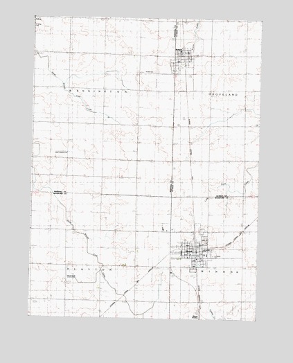
Minonk, IL USGS Topographic Map
Click on map above to begin viewing in our Map Viewer.

This topographic map contains these locations and features:
Feature Name Type Latitude Longitude GNIS ID View Map
City of MinonkCivilN40.9104°W89.0381°2395353View Map
Fieldcrest Elementary School-SouthSchoolN40.9023°W89.0384°1824274View Map
Fieldcrest High SchoolSchoolN40.9017°W89.0292°1824275View Map
Hattan Farms AirportAirportN40.9332°W89.1207°427544View Map
Immanuel Lutheran ChurchChurchN40.9006°W89.0381°1985441View Map
John W Meils RLA Airport (historical)AirportN40.9500°W89.1167°427777View Map
MinonkPopulated PlaceN40.9045°W89.0345°413658View Map
Minonk Baptist ChurchChurchN40.9023°W89.0312°1985442View Map
Minonk CemeteryCemeteryN40.9117°W89.0301°1953795View Map
Minonk Emergency SquadBuildingN40.9040°W89.0415°2673884View Map
Minonk Fire Protection DistrictBuildingN40.9037°W89.0344°2640480View Map
Minonk Police DepartmentBuildingN40.9041°W89.0344°2756885View Map
Minonk Post OfficePost OfficeN40.9019°W89.0348°2788339View Map
Oltman-Shuck AirportAirportN40.8895°W89.1040°427546View Map
RutlandPopulated PlaceN40.9842°W89.0417°417078View Map
Rutland CemeteryCemeteryN40.9775°W89.0587°417079View Map
Rutland Fire Protection DistrictBuildingN40.9833°W89.0427°2681886View Map
Rutland Post OfficePost OfficeN40.9833°W89.0426°2788714View Map
Saint Johns CemeteryCemeteryN40.9961°W89.1248°417376View Map
Saint Patrick ChurchChurchN40.9036°W89.0298°1985443View Map
Saint Patricks CemeteryCemeteryN40.9011°W89.0245°1802030View Map
Saint Patricks SchoolSchoolN40.9039°W89.0295°1802031View Map
Saint Pauls United Church of ChristChurchN40.9020°W89.0367°1985447View Map
Township of BenningtonCivilN40.9705°W89.1043°428658View Map
Township of ClaytonCivilN40.8824°W89.1037°428818View Map
United Methodist Church of MinonkChurchN40.9036°W89.0315°1985448View Map
Village of RutlandCivilN40.9838°W89.0413°2399151View Map

Note: Coordinates in the location and feature list above are referenced to NAD83 datum.


Copyright (C) 2008-2025 Ryan Niemi / Sunset Dynamics ... All Rights Reserved