TopoQuest Logo
Do you find TopoQuest useful?
Help keep TopoQuest running and adding new maps/features by donating!
Bitcoin:  19c7KJd3qBynnjoSw5npx9KScwjBe4ifkT
Litecoin:  LXs6TkuXGGXo1vDsWCkWVdjQX94eUKd6ui
Home View Maps Find Maps Find Places Resources & Links


Jewell, Georgia Topographic Map

USGS Map Title: Jewell, GA
USGS Map MRC: 33082C7
DRG (GeoTIFF) Download: o33082c7.tif


Neighboring USGS Topographic Map Quads:


  Sparta NW, GA  
33082D8
 

  Sparta NE, GA  
33082D7
 

  Warrenton, GA  
33082D6
 

  Sparta, GA  
33082C8
 

  Jewell, GA  
33082C7
 

  Beall Springs, GA  
33082C6
 

  Warthen NW, GA  
33082B8
 

  Warthen NE, GA  
33082B7
 

  Mitchell, GA  
33082B6


Map MRC Location:

N34°
W83°
N34°
W82°
H8 H7 H6 H5 H4 H3 H2 H1
G8 G7 G6 G5 G4 G3 G2 G1
F8 F7 F6 F5 F4 F3 F2 F1
E8 E7 E6 E5 E4 E3 E2 E1
D8 D7 D6 D5 D4 D3 D2 D1
C8 C7 C6 C5 C4 C3 C2 C1
B8 B7 B6 B5 B4 B3 B2 B1
A8 A7 A6 A5 A4 A3 A2 A1
N33°
W83°
N33°
W82°

Jewell, GA USGS 1:24K Topographic Map Preview:
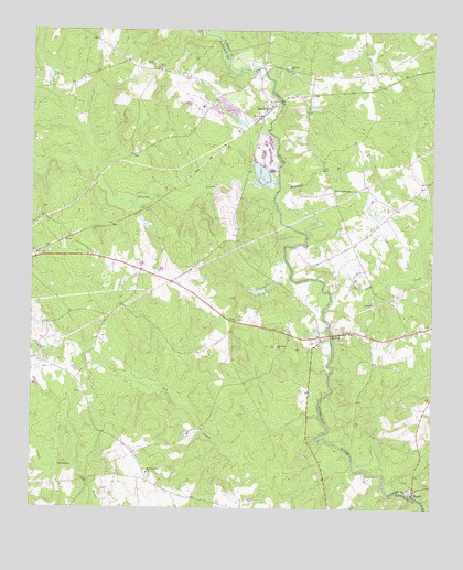
Jewell, GA USGS Topographic Map
Click on map above to begin viewing in our Map Viewer.

This topographic map contains these locations and features:
Feature Name Type Latitude Longitude GNIS ID View Map
AnsleyPopulated PlaceN33.3188°W82.7749°347662View Map
Brinson-Latimer CemeteryCemeteryN33.3651°W82.7893°347671View Map
Coleman-Middlebrooks Family CemeteryCemeteryN33.3285°W82.8726°1985788View Map
Dixon PondReservoirN33.2697°W82.8265°348201View Map
Dry CreekStreamN33.2735°W82.7840°355556View Map
Dunns CemeteryCemeteryN33.2804°W82.8593°348202View Map
Durbeys Chapel CemeteryCemeteryN33.2987°W82.7554°347688View Map
Evans-Taylor CemeteryCemeteryN33.3621°W82.7821°347694View Map
Ezell-Carr Family CemeteryCemeteryN33.2868°W82.8696°1985799View Map
Fish HatcheryLocaleN33.3368°W82.8015°340643View Map
Fish Hatchery DamDamN33.3368°W82.8015°340642View Map
Fulsome CreekStreamN33.3315°W82.7987°355968View Map
Gonder Family CemeteryCemeteryN33.3279°W82.8707°1985807View Map
Gonder-Poole CemeteryCemeteryN33.3290°W82.8718°1985809View Map
Hale LakeReservoirN33.3069°W82.8042°336423View Map
Hale Lake DamDamN33.3068°W82.8015°336422View Map
Hickory Grove CemeteryCemeteryN33.2590°W82.8379°348213View Map
Hickory Grove ChurchChurchN33.2593°W82.8382°356272View Map
Horeb CemeteryCemeteryN33.3665°W82.8371°348215View Map
Horeb ChurchChurchN33.3668°W82.8365°315672View Map
Jewel Historic DistrictParkN33.2949°W82.7846°348222View Map
JewellPopulated PlaceN33.2963°W82.7774°332098View Map
Jewell Baptist ChurchChurchN33.2926°W82.7851°348220View Map
Jewell CemeteryCemeteryN33.2926°W82.7854°348221View Map
Latimer-Heath Family CemeteryCemeteryN33.3071°W82.8512°1985828View Map
Long CreekStreamN33.3015°W82.7835°317349View Map
Martin Tabernacle ChurchChurchN33.3329°W82.7801°317750View Map
MayfieldPopulated PlaceN33.3551°W82.8007°332340View Map
Mayfield DivisionCivilN33.3404°W82.8609°1936396View Map
McCown GraveCemeteryN33.3546°W82.8026°1985832View Map
Medlock Family CemeteryCemeteryN33.3229°W82.8482°1985834View Map
Mill Rock CemeteryCemeteryN33.3651°W82.7951°347735View Map
Millrock ChurchChurchN33.3660°W82.7946°318283View Map
Reynolds BranchStreamN33.3335°W82.7979°321538View Map
Rock Mills CemeteryCemeteryN33.3076°W82.8049°348252View Map
Rock Mills Methodist Church (historical)ChurchN33.3076°W82.8051°348253View Map
Shivers Family CemeteryCemeteryN33.3118°W82.7974°1985850View Map
ShoalsLocaleN33.2549°W82.7551°322948View Map
Shoals CemeteryCemeteryN33.2574°W82.7585°347761View Map
Shoals Primitive Baptist ChurchChurchN33.2554°W82.7549°347762View Map
Short CreekStreamN33.3185°W82.7526°322956View Map
Stevens Mill (historical)LocaleN33.3646°W82.8024°347765View Map
Thankful Baptist Church CemeteryCemeteryN33.2926°W82.7985°1985862View Map
Thankful ChurchChurchN33.2926°W82.7974°324024View Map
Thankful School (historical)SchoolN33.2960°W82.7949°348272View Map
Trinity ChurchChurchN33.2996°W82.8107°324311View Map
Union CemeteryCemeteryN33.3640°W82.8351°348273View Map
Union ChurchChurchN33.3657°W82.8349°324530View Map
Union School (historical)SchoolN33.3649°W82.8357°348274View Map
Wilson CemeteryCemeteryN33.2568°W82.8043°1985872View Map

Note: Coordinates in the location and feature list above are referenced to NAD83 datum.


Copyright (C) 2008-2025 Ryan Niemi / Sunset Dynamics ... All Rights Reserved