TopoQuest Logo
Do you find TopoQuest useful?
Help keep TopoQuest running and adding new maps/features by donating!
Bitcoin:  19c7KJd3qBynnjoSw5npx9KScwjBe4ifkT
Litecoin:  LXs6TkuXGGXo1vDsWCkWVdjQX94eUKd6ui
Home View Maps Find Maps Find Places Resources & Links


Williamstown, Missouri Topographic Map

USGS Map Title: Williamstown, MO
USGS Map MRC: 40091B7
DRG (GeoTIFF) Download: o40091b7.tif


Neighboring USGS Topographic Map Quads:


  Colony, MO  
40091C8
 

  Neeper, MO  
40091C7
 

  Saint Patrick, MO  
40091C6
 

  Deer Ridge, MO  
40091B8
 

  Williamstown, MO  
40091B7
 

  Benjamin, MO  
40091B6
 

  La Belle, MO  
40091A8
 

  Lewistown, MO  
40091A7
 

  Monticello, MO  
40091A6


Map MRC Location:

N41°
W92°
N41°
W91°
H8 H7 H6 H5 H4 H3 H2 H1
G8 G7 G6 G5 G4 G3 G2 G1
F8 F7 F6 F5 F4 F3 F2 F1
E8 E7 E6 E5 E4 E3 E2 E1
D8 D7 D6 D5 D4 D3 D2 D1
C8 C7 C6 C5 C4 C3 C2 C1
B8 B7 B6 B5 B4 B3 B2 B1
A8 A7 A6 A5 A4 A3 A2 A1
N40°
W92°
N40°
W91°

Williamstown, MO USGS 1:24K Topographic Map Preview:
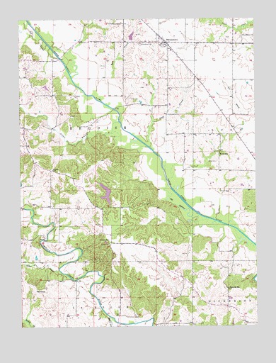
Williamstown, MO USGS Topographic Map
Click on map above to begin viewing in our Map Viewer.

This topographic map contains these locations and features:
Feature Name Type Latitude Longitude GNIS ID View Map
Bowls SchoolSchoolN40.1398°W91.8668°735525View Map
Buck BranchStreamN40.2148°W91.8277°714953View Map
Buck Branch School (historical)SchoolN40.2384°W91.8191°732798View Map
Catfish LakeReservoirN40.2224°W91.8610°762214View Map
Catfish Lake DamDamN40.2234°W91.8618°762213View Map
Cecil CemeteryCemeteryN40.2178°W91.8157°715560View Map
Cooper BranchStreamN40.2081°W91.8227°716275View Map
Deer Ridge Community LakeReservoirN40.1792°W91.8299°760367View Map
Deer Ridge Community Lake DamDamN40.1800°W91.8268°760366View Map
EgyptAreaN40.1808°W91.8217°732799View Map
Forsee BranchStreamN40.1981°W91.8063°718106View Map
H T LakeReservoirN40.1533°W91.8671°762210View Map
H T Lake DamDamN40.1534°W91.8668°762209View Map
Hilbert BranchStreamN40.1467°W91.8532°735650View Map
McLain BridgeBridgeN40.2342°W91.8535°732800View Map
MidwayPopulated PlaceN40.1589°W91.8271°732801View Map
Midway CemeteryCemeteryN40.1586°W91.8285°722299View Map
Midway Chapel (historical)ChurchN40.1592°W91.8274°732802View Map
Morris CemeteryCemeteryN40.1917°W91.7710°722646View Map
Morris SchoolSchoolN40.1950°W91.7693°722652View Map
Murphy LakeReservoirN40.2426°W91.8156°760534View Map
Murphy Lake DamDamN40.2416°W91.8158°760533View Map
Old Channel North Fabius RiverStreamN40.1670°W91.7696°723731View Map
Providence Baptist ChurchChurchN40.2431°W91.7568°754136View Map
Reddish BranchStreamN40.1289°W91.8282°725172View Map
Reynolds SchoolSchoolN40.1403°W91.7654°725238View Map
Ronald Lay LakeReservoirN40.1417°W91.7918°762208View Map
Ronald Lay Lake DamDamN40.1417°W91.7918°762207View Map
Stice LakeReservoirN40.1594°W91.8301°762212View Map
Stice Lake DamDamN40.1600°W91.8302°762211View Map
Township of ReddishCivilN40.2042°W91.8662°766897View Map
Turpin SchoolSchoolN40.1595°W91.8288°727914View Map
Walker SchoolSchoolN40.1887°W91.8577°728268View Map
WilliamstownPopulated PlaceN40.2409°W91.7971°728908View Map
Williamstown CemeteryCemeteryN40.2403°W91.8102°728909View Map
Williamstown Volunteer Fire DepartmentBuildingN40.2392°W91.7969°2621011View Map
Wurtzburger LakeReservoirN40.2267°W91.7852°762216View Map
Wurtzburger Lake DamDamN40.2267°W91.7852°762215View Map

Note: Coordinates in the location and feature list above are referenced to NAD83 datum.


Copyright (C) 2008-2025 Ryan Niemi / Sunset Dynamics ... All Rights Reserved