TopoQuest Logo
Do you find TopoQuest useful?
Help keep TopoQuest running and adding new maps/features by donating!
Bitcoin:  19c7KJd3qBynnjoSw5npx9KScwjBe4ifkT
Litecoin:  LXs6TkuXGGXo1vDsWCkWVdjQX94eUKd6ui
Home View Maps Find Maps Find Places Resources & Links


Bedford East, Indiana Topographic Map

USGS Map Title: Bedford East, IN
USGS Map MRC: 38086G4
DRG (GeoTIFF) Download: o38086g4.tif


Neighboring USGS Topographic Map Quads:


  Oolitic, IN  
38086H5
 

  Bartlettsville, IN  
38086H4
 

  Norman, IN  
38086H3
 

  Bedford West, IN  
38086G5
 

  Bedford East, IN  
38086G4
 

  Tunnelton, IN  
38086G3
 

  Georgia, IN  
38086F5
 

  Mitchell, IN  
38086F4
 

  Campbellsburg, IN  
38086F3


Map MRC Location:

N39°
W87°
N39°
W86°
H8 H7 H6 H5 H4 H3 H2 H1
G8 G7 G6 G5 G4 G3 G2 G1
F8 F7 F6 F5 F4 F3 F2 F1
E8 E7 E6 E5 E4 E3 E2 E1
D8 D7 D6 D5 D4 D3 D2 D1
C8 C7 C6 C5 C4 C3 C2 C1
B8 B7 B6 B5 B4 B3 B2 B1
A8 A7 A6 A5 A4 A3 A2 A1
N38°
W87°
N38°
W86°

Bedford East, IN USGS 1:24K Topographic Map Preview:
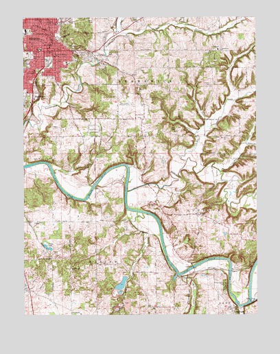
Bedford East, IN USGS Topographic Map
Click on map above to begin viewing in our Map Viewer.

This topographic map contains these locations and features:
Feature Name Type Latitude Longitude GNIS ID View Map
BedfordPopulated PlaceN38.8612°W86.4872°450667View Map
Bedford Christian CampParkN38.8156°W86.4878°430699View Map
Bedford Fire Department Central StationBuildingN38.8569°W86.4808°2701347View Map
Bedford Fire Department Station 1 CentralBuildingN38.8569°W86.4808°2625547View Map
Bedford Fire Department Station 2BuildingN38.8742°W86.4913°2625905View Map
Bedford Middle SchoolSchoolN38.8616°W86.4904°447391View Map
Bedford Police DepartmentBuildingN38.8606°W86.4860°2758183View Map
Bedford Post OfficePost OfficeN38.8594°W86.4809°2766644View Map
Beech Grove CemeteryCemeteryN38.8587°W86.4958°430721View Map
Bishop Roberts ParkParkN38.7631°W86.3917°431109View Map
BuddhaPopulated PlaceN38.7920°W86.4067°431762View Map
Carlton CemeteryCemeteryN38.7962°W86.4294°432140View Map
City of BedfordCivilN38.8602°W86.4895°2394104View Map
CrawfordPopulated PlaceN38.8459°W86.3972°452113View Map
Crawford CemeteryCemeteryN38.8464°W86.3992°433098View Map
Crawford CreekStreamN38.8106°W86.3950°433099View Map
DeWitt CreekStreamN38.8148°W86.4125°433377View Map
EnglewoodPopulated PlaceN38.8445°W86.4980°434202View Map
Erwin CemeteryCemeteryN38.7731°W86.4608°434236View Map
Evans QuarryMineN38.8128°W86.4717°2649424View Map
Fishing CreekStreamN38.7531°W86.3836°434529View Map
Furst ParkParkN38.8737°W86.4978°434908View Map
Green Hill CemeteryCemeteryN38.8559°W86.4872°435402View Map
Guthrie CreekStreamN38.8023°W86.4444°450993View Map
Guthrie Township Volunteer Fire Department Station 2BuildingN38.7891°W86.3976°2626286View Map
Ikerd CemeteryCemeteryN38.8698°W86.4392°436706View Map
Lawrence CountyCivilN38.8412°W86.4835°451703View Map
Lawrence County JailBuildingN38.8625°W86.4824°2766642View Map
Lawrence County Sheriff's OfficeBuildingN38.8625°W86.4823°2758204View Map
LawrenceportPopulated PlaceN38.7512°W86.3878°437676View Map
Leatherwood ChurchChurchN38.8612°W86.3936°437708View Map
Lincoln Elementary SchoolSchoolN38.8562°W86.4769°437923View Map
Mill CreekStreamN38.7667°W86.4158°439155View Map
Otis ParkParkN38.8595°W86.4544°440731View Map
RabbitvillePopulated PlaceN38.7687°W86.4739°441711View Map
RivervalePopulated PlaceN38.7689°W86.3980°449719View Map
Rock Lick BranchStreamN38.7928°W86.4361°442206View Map
Saint Vincent Depaul SchoolSchoolN38.8592°W86.4833°442856View Map
Saint Vincent Dunn HospitalHospitalN38.8530°W86.4940°433796View Map
Scoggan CemeteryCemeteryN38.8289°W86.4814°443132View Map
Shawswick Elementary and Junior High SchoolSchoolN38.8617°W86.3955°447390View Map
Shawswick Volunteer Fire Department Station 1BuildingN38.8326°W86.4481°2626416View Map
Sheeks CemeteryCemeteryN38.7875°W86.4539°443329View Map
Sheeks LakeLakeN38.7789°W86.4877°443330View Map
South Fork Crawford CreekStreamN38.8220°W86.3800°443804View Map
South Fork Leatherwood CreekStreamN38.8659°W86.4508°451481View Map
Stalker Elementary SchoolSchoolN38.8714°W86.4908°444051View Map
Starr CemeteryCemeteryN38.8248°W86.3914°444078View Map
Sugar CreekStreamN38.7553°W86.3780°444318View Map
Thornton ParkParkN38.8601°W86.4961°444735View Map
Township of ShawswickCivilN38.8583°W86.4352°453842View Map
Trinity ChurchChurchN38.8323°W86.4361°444895View Map
Virgil I Grissom Municipal AirportAirportN38.8383°W86.4365°451812View Map
Water Madden SchoolSchoolN38.8726°W86.4814°445532View Map
WBIF-FM (Bedford)TowerN38.8731°W86.4761°448952View Map
WBIW-AM (Bedford)TowerN38.8731°W86.4761°448466View Map
Wilson ParkParkN38.8551°W86.4992°446151View Map
WoodvillePopulated PlaceN38.7559°W86.4850°448361View Map
YockeyPopulated PlaceN38.7881°W86.4930°446395View Map

Note: Coordinates in the location and feature list above are referenced to NAD83 datum.


Copyright (C) 2008-2025 Ryan Niemi / Sunset Dynamics ... All Rights Reserved