TopoQuest Logo
Do you find TopoQuest useful?
Help keep TopoQuest running and adding new maps/features by donating!
Bitcoin:  19c7KJd3qBynnjoSw5npx9KScwjBe4ifkT
Litecoin:  LXs6TkuXGGXo1vDsWCkWVdjQX94eUKd6ui
Home View Maps Find Maps Find Places Resources & Links


Tunnelton, Indiana Topographic Map

USGS Map Title: Tunnelton, IN
USGS Map MRC: 38086G3
DRG (GeoTIFF) Download: o38086g3.tif


Neighboring USGS Topographic Map Quads:


  Bartlettsville, IN  
38086H4
 

  Norman, IN  
38086H3
 

  Kurtz, IN  
38086H2
 

  Bedford East, IN  
38086G4
 

  Tunnelton, IN  
38086G3
 

  Medora, IN  
38086G2
 

  Mitchell, IN  
38086F4
 

  Campbellsburg, IN  
38086F3
 

  Smedley, IN  
38086F2


Map MRC Location:

N39°
W87°
N39°
W86°
H8 H7 H6 H5 H4 H3 H2 H1
G8 G7 G6 G5 G4 G3 G2 G1
F8 F7 F6 F5 F4 F3 F2 F1
E8 E7 E6 E5 E4 E3 E2 E1
D8 D7 D6 D5 D4 D3 D2 D1
C8 C7 C6 C5 C4 C3 C2 C1
B8 B7 B6 B5 B4 B3 B2 B1
A8 A7 A6 A5 A4 A3 A2 A1
N38°
W87°
N38°
W86°

Tunnelton, IN USGS 1:24K Topographic Map Preview:
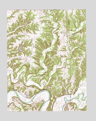
Tunnelton, IN USGS Topographic Map
Click on map above to begin viewing in our Map Viewer.

This topographic map contains these locations and features:
Feature Name Type Latitude Longitude GNIS ID View Map
Back CreekStreamN38.7848°W86.3478°450639View Map
Brown CemeteryCemeteryN38.8116°W86.2561°431599View Map
Coxs Ferry (historical)LocaleN38.7606°W86.2822°448386View Map
Dennison RidgeRidgeN38.8239°W86.3344°433477View Map
Devils BackboneRidgeN38.7762°W86.3194°433499View Map
Ditney RidgeRidgeN38.7967°W86.3133°433572View Map
Dixon ChapelChurchN38.8017°W86.2769°433579View Map
Dodd CemeteryCemeteryN38.7792°W86.3355°433593View Map
Dry CreekStreamN38.8220°W86.2758°433717View Map
Fairview ChurchChurchN38.8709°W86.3161°434335View Map
Fort RitnerPopulated PlaceN38.7731°W86.2811°434688View Map
Guthrie Township Volunteer Fire Department Station 1BuildingN38.8480°W86.2860°2626030View Map
Jones Defeat HollowValleyN38.8254°W86.3161°437093View Map
Ken-Ray LakeReservoirN38.8249°W86.3536°447296View Map
Ken-Ray Lake DamDamN38.8255°W86.3557°447297View Map
LeesvillePopulated PlaceN38.8456°W86.2844°437744View Map
PinhookPopulated PlaceN38.8153°W86.3564°441169View Map
Shawswick Township Volunteer Fire Department Station 4BuildingN38.8386°W86.3533°2701386View Map
Shawswick Volunteer Fire Department Station 4BuildingN38.8333°W86.3560°2626277View Map
Sherril CemeteryCemeteryN38.8420°W86.3692°443366View Map
Township of GuthrieCivilN38.8028°W86.3339°453359View Map
Tunnel HillSummitN38.7656°W86.3058°444952View Map
TunneltonPopulated PlaceN38.7687°W86.3428°444956View Map
Twin CreekStreamN38.7645°W86.2633°445011View Map

Note: Coordinates in the location and feature list above are referenced to NAD83 datum.


Copyright (C) 2008-2024 Ryan Niemi / Sunset Dynamics ... All Rights Reserved