TopoQuest Logo
Do you find TopoQuest useful?
Help keep TopoQuest running and adding new maps/features by donating!
Bitcoin:  19c7KJd3qBynnjoSw5npx9KScwjBe4ifkT
Litecoin:  LXs6TkuXGGXo1vDsWCkWVdjQX94eUKd6ui
Home View Maps Find Maps Find Places Resources & Links


Mitchell, Indiana Topographic Map

USGS Map Title: Mitchell, IN
USGS Map MRC: 38086F4
DRG (GeoTIFF) Download: o38086f4.tif


Neighboring USGS Topographic Map Quads:


  Bedford West, IN  
38086G5
 

  Bedford East, IN  
38086G4
 

  Tunnelton, IN  
38086G3
 

  Georgia, IN  
38086F5
 

  Mitchell, IN  
38086F4
 

  Campbellsburg, IN  
38086F3
 

  French Lick, IN  
38086E5
 

  Paoli, IN  
38086E4
 

  Livonia, IN  
38086E3


Map MRC Location:

N39°
W87°
N39°
W86°
H8 H7 H6 H5 H4 H3 H2 H1
G8 G7 G6 G5 G4 G3 G2 G1
F8 F7 F6 F5 F4 F3 F2 F1
E8 E7 E6 E5 E4 E3 E2 E1
D8 D7 D6 D5 D4 D3 D2 D1
C8 C7 C6 C5 C4 C3 C2 C1
B8 B7 B6 B5 B4 B3 B2 B1
A8 A7 A6 A5 A4 A3 A2 A1
N38°
W87°
N38°
W86°

Mitchell, IN USGS 1:24K Topographic Map Preview:
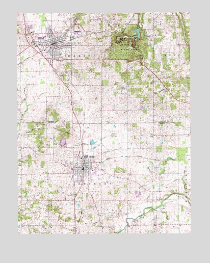
Mitchell, IN USGS Topographic Map
Click on map above to begin viewing in our Map Viewer.

This topographic map contains these locations and features:
Feature Name Type Latitude Longitude GNIS ID View Map
Arnold CreekStreamN38.7176°W86.4080°430275View Map
Burris Elementary SchoolSchoolN38.7395°W86.4422°431871View Map
City of MitchellCivilN38.7363°W86.4746°2395357View Map
Crandall FarmsLocaleN38.6286°W86.3964°2635434View Map
Fairview CemeteryCemeteryN38.6639°W86.4611°434313View Map
First Baptist Church of OrleansChurchN38.6611°W86.4408°2649824View Map
Freedom CemeteryCemeteryN38.7150°W86.4700°434805View Map
Hamer CemeteryCemeteryN38.7328°W86.4214°435634View Map
Holiday Drive-InLocaleN38.7022°W86.4617°2634485View Map
Liberty ChurchChurchN38.6809°W86.4022°437826View Map
Marion Township Rural Fire DepartmentBuildingN38.7448°W86.4937°2626583View Map
MitchellPopulated PlaceN38.7328°W86.4736°439292View Map
Mitchell Fire Department Station 1BuildingN38.7289°W86.4710°2625509View Map
Mitchell Fire Department Station 2BuildingN38.7342°W86.4707°2626401View Map
Mitchell High SchoolSchoolN38.7367°W86.4769°447392View Map
Mitchell Police DeptBuildingN38.7294°W86.4708°2758420View Map
Mount Carmel ChurchChurchN38.6628°W86.4586°439545View Map
Mount Hebron ChurchChurchN38.6776°W86.3755°439574View Map
Old CemeteryCemeteryN38.6623°W86.4589°440547View Map
Orange County House of PrayerChurchN38.6608°W86.4511°2649826View Map
Orange County Rural Volunteer Fire Department District 2BuildingN38.6597°W86.4560°2626344View Map
OrleansPopulated PlaceN38.6617°W86.4517°440701View Map
Orleans AirportAirportN38.6555°W86.4467°449296View Map
Orleans Elementary SchoolSchoolN38.6609°W86.4458°447196View Map
Orleans Junior Senior High SchoolSchoolN38.6679°W86.4543°447195View Map
Orleans Police DepartmentBuildingN38.6631°W86.4525°2758120View Map
Orleans Post OfficePost OfficeN38.6614°W86.4544°2766645View Map
Orleans QuarryMineN38.6767°W86.4664°2649674View Map
Orleans Springs (historical)SpringN38.6745°W86.4478°448377View Map
Orleans United Methodist ChurchChurchN38.6619°W86.4544°2649825View Map
Orleans Volunteer Fire DepartmentBuildingN38.6636°W86.4519°2625984View Map
Orleans Water Works ReservoirReservoirN38.6762°W86.4465°447428View Map
Orleans Water Works Reservoir DamDamN38.6765°W86.4472°447427View Map
Pilgrim CampgroundLocaleN38.6470°W86.4583°441140View Map
Purdue Experimental OrchardLocaleN38.7078°W86.4264°452387View Map
River View FarmsLocaleN38.6317°W86.4131°2635432View Map
Small DrainStreamN38.6462°W86.3803°443643View Map
Spring Mall Park LakeReservoirN38.7434°W86.4117°448634View Map
Spring Mall Park Lake DamDamN38.7434°W86.4117°448633View Map
Spring Mill State ParkParkN38.7334°W86.4200°446874View Map
Spring Mill VillagePopulated PlaceN38.7351°W86.4269°443995View Map
Tom Rice HillSummitN38.6848°W86.4875°444807View Map
Town of OrleansCivilN38.6615°W86.4516°2396837View Map
Township of MarionCivilN38.7489°W86.4838°453609View Map
Township of OrleansCivilN38.6515°W86.4500°453695View Map
Union ChapelChurchN38.6301°W86.4642°445081View Map
Water RunStreamN38.6401°W86.3983°445534View Map

Note: Coordinates in the location and feature list above are referenced to NAD83 datum.


Copyright (C) 2008-2024 Ryan Niemi / Sunset Dynamics ... All Rights Reserved