TopoQuest Logo
Do you find TopoQuest useful?
Help keep TopoQuest running and adding new maps/features by donating!
Bitcoin:  19c7KJd3qBynnjoSw5npx9KScwjBe4ifkT
Litecoin:  LXs6TkuXGGXo1vDsWCkWVdjQX94eUKd6ui
Home View Maps Find Maps Find Places Resources & Links


Moorefield, West Virginia Topographic Map

USGS Map Title: Moorefield, WV
USGS Map MRC: 39078A8
DRG (GeoTIFF) Download: o39078a8.tif


Neighboring USGS Topographic Map Quads:


  Medley, WV  
39079B1
 

  Old Fields, WV  
39078B8
 

  Sector, WV  
39078B7
 

  Rig, WV  
39079A1
 

  Moorefield, WV  
39078A8
 

  Needmore, WV  
39078A7
 

  Petersburg East, WV  
38079H1
 

  Lost River State Park, WV  
38078H8
 

  Lost City, WV  
38078H7


Map MRC Location:

N40°
W79°
N40°
W78°
H8 H7 H6 H5 H4 H3 H2 H1
G8 G7 G6 G5 G4 G3 G2 G1
F8 F7 F6 F5 F4 F3 F2 F1
E8 E7 E6 E5 E4 E3 E2 E1
D8 D7 D6 D5 D4 D3 D2 D1
C8 C7 C6 C5 C4 C3 C2 C1
B8 B7 B6 B5 B4 B3 B2 B1
A8 A7 A6 A5 A4 A3 A2 A1
N39°
W79°
N39°
W78°

Moorefield, WV USGS 1:24K Topographic Map Preview:
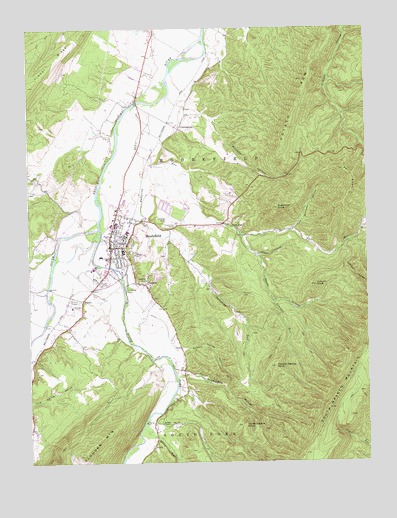
Moorefield, WV USGS Topographic Map
Click on map above to begin viewing in our Map Viewer.

This topographic map contains these locations and features:
Feature Name Type Latitude Longitude GNIS ID View Map
Baldwin CemeteryCemeteryN39.0484°W78.9211°1535170View Map
Burlington CemeteryCemeteryN39.0023°W78.9203°1936843View Map
Clifford Hollow BridgeBridgeN39.0940°W78.8800°2646965View Map
Coburn KnobSummitN39.0509°W78.8942°1537488View Map
CunninghamPopulated PlaceN39.0962°W78.9439°1554243View Map
Dover HollowValleyN39.0632°W78.9200°1538301View Map
Dover School (historical)SchoolN39.0557°W78.9131°1556834View Map
Dumpling RunStreamN39.0987°W78.9575°1538422View Map
Fort RunPopulated PlaceN39.0668°W78.9225°1554497View Map
Fort RunStreamN39.1029°W78.9600°1551165View Map
Fort Run ChurchChurchN39.0659°W78.9211°1556836View Map
Fraley Ambulance ServiceBuildingN39.0645°W78.9693°2581079View Map
Hardy County CourthouseBuildingN39.0640°W78.9681°1718558View Map
Hardy County Public LibraryBuildingN39.0632°W78.9700°1718559View Map
Hardy County Sheriff's OfficeBuildingN39.0643°W78.9677°2727941View Map
Harpers ChapelChurchN39.0115°W78.9517°1539997View Map
Harry Veeders SpringSpringN39.0184°W78.9761°1678109View Map
Hutton RunStreamN39.0496°W78.9936°1540643View Map
Jemima HollowValleyN39.0615°W78.8828°1551565View Map
Mapleton (historical)Populated PlaceN39.1165°W78.9331°1556850View Map
MeadowPopulated PlaceN39.0904°W78.9539°1718568View Map
MoorefieldPopulated PlaceN39.0623°W78.9695°1543520View Map
Moorefield DistrictCivilN39.0524°W78.9107°1928317View Map
Moorefield Elementary SchoolSchoolN39.0687°W78.9692°1718570View Map
Moorefield High SchoolSchoolN39.0688°W78.9677°1718571View Map
Moorefield Historic DistrictParkN39.0637°W78.9673°1718572View Map
Moorefield Intermediate SchoolSchoolN39.0688°W78.9479°2487455View Map
Moorefield Middle SchoolSchoolN39.0691°W78.9450°2088279View Map
Moorefield Police DepartmentBuildingN39.0624°W78.9675°2727940View Map
Moorefield Post OfficePost OfficeN39.0706°W78.9606°1718573View Map
Moorefield Volunteer Fire DepartmentBuildingN39.0655°W78.9712°2577565View Map
New Buzzard Ford BridgeBridgeN39.0503°W78.9930°2646970View Map
Oak Hill CemeteryCemeteryN39.0609°W78.9611°1544299View Map
Olivet CemeteryCemeteryN39.0634°W78.9622°1544401View Map
Parren School (historical)SchoolN39.0071°W78.9539°1556860View Map
Parsons Ford BridgeBridgeN39.1038°W78.9591°2646968View Map
Phils KnobSummitN39.0768°W78.8814°1544788View Map
Potato RowRidgeN39.1037°W78.8992°1545185View Map
Potter Run School (historical)SchoolN39.0448°W78.9259°1556863View Map
Powder Spring KnobSummitN39.0276°W78.9092°1545206View Map
Sawmill RunStreamN39.0657°W78.9211°1546463View Map
South Branch Cinema 6BuildingN39.0828°W78.9575°2725054View Map
South Fork South Branch Potomac RiverStreamN39.0676°W78.9731°1552982View Map
Stony RunStreamN39.0101°W78.9586°1547503View Map
Sugarcamp HollowValleyN39.0254°W78.9417°1547679View Map
Sugarloaf KnobSummitN39.0732°W78.9075°1547699View Map
Sulphur Spring HollowValleyN39.0329°W78.9434°1547720View Map
TanneryPopulated PlaceN39.0515°W78.9572°1555780View Map
Tannery Presbyterian ChurchChurchN39.0501°W78.9559°1718586View Map
TaylorPopulated PlaceN39.0471°W78.9798°1555786View Map
Three Square KnobSummitN39.0098°W78.9211°1555809View Map
Timber RidgeRidgeN39.1159°W78.9892°1548096View Map
Tom Williams HollowValleyN39.0673°W78.9014°1548120View Map
Town of MoorefieldCivilN39.0673°W78.9624°2391314View Map
Wendell Dell Hester Memorial BridgeBridgeN39.0560°W78.9705°2646972View Map
West Virginia Division of Forestry Hardy County Field OfficeBuildingN39.0442°W78.9818°2577809View Map
Williams HollowValleyN39.1004°W78.9350°1549177View Map
Wood HollowValleyN39.0601°W78.9142°1549365View Map

Note: Coordinates in the location and feature list above are referenced to NAD83 datum.


Copyright (C) 2008-2024 Ryan Niemi / Sunset Dynamics ... All Rights Reserved