TopoQuest Logo
Do you find TopoQuest useful?
Help keep TopoQuest running and adding new maps/features by donating!
Bitcoin:  19c7KJd3qBynnjoSw5npx9KScwjBe4ifkT
Litecoin:  LXs6TkuXGGXo1vDsWCkWVdjQX94eUKd6ui
Home View Maps Find Maps Find Places Resources & Links


Western Grove, Arkansas Topographic Map

USGS Map Title: Western Grove, AR
USGS Map MRC: 36092A8
DRG (GeoTIFF) Download: o36092a8.tif


Neighboring USGS Topographic Map Quads:


  Harrison, AR  
36093B1
 

  Everton, AR  
36092B8
 

  Bruno, AR  
36092B7
 

  Hasty, AR  
36093A1
 

  Western Grove, AR  
36092A8
 

  Saint Joe, AR  
36092A7
 

  Mount Judea, AR  
35093H1
 

  Eula, AR  
35092H8
 

  Snowball, AR  
35092H7


Map MRC Location:

N37°
W93°
N37°
W92°
H8 H7 H6 H5 H4 H3 H2 H1
G8 G7 G6 G5 G4 G3 G2 G1
F8 F7 F6 F5 F4 F3 F2 F1
E8 E7 E6 E5 E4 E3 E2 E1
D8 D7 D6 D5 D4 D3 D2 D1
C8 C7 C6 C5 C4 C3 C2 C1
B8 B7 B6 B5 B4 B3 B2 B1
A8 A7 A6 A5 A4 A3 A2 A1
N36°
W93°
N36°
W92°

Western Grove, AR USGS 1:24K Topographic Map Preview:
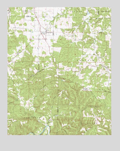
Western Grove, AR USGS Topographic Map
Click on map above to begin viewing in our Map Viewer.

This topographic map contains these locations and features:
Feature Name Type Latitude Longitude GNIS ID View Map
Bald Knob CemeteryCemeteryN36.1212°W92.9468°46044View Map
Cane Branch HillsRangeN36.0067°W92.9024°70983View Map
Cave Spring HollowValleyN36.0231°W92.9121°47554View Map
Chinquapin SpringSpringN36.0457°W92.9043°47758View Map
Chinquapin Spring RidgeRidgeN36.0365°W92.8932°47759View Map
Clutes (historical)Populated PlaceN36.0431°W92.8835°69955View Map
Copper BluffCliffN36.0059°W92.9488°81817View Map
Davis CreekStreamN36.0090°W92.9532°71343View Map
Dugger CemeteryCemeteryN36.1248°W92.9207°48689View Map
Dugger SpringSpringN36.1134°W92.9046°48691View Map
East Fork Clear CreekStreamN36.0995°W92.8966°48761View Map
Glencoe CemeteryCemeteryN36.0899°W92.8960°49444View Map
Glencoe SpringSpringN36.1006°W92.8866°49445View Map
Hurricane BranchStreamN36.0267°W92.9724°50431View Map
Hurricane MineMineN36.0529°W92.9310°69962View Map
Kilburn CemeteryCemeteryN36.0465°W92.9037°50836View Map
Lead HillSummitN36.0045°W92.9388°72294View Map
Mill BranchStreamN36.0092°W92.9527°51974View Map
Mitch Hill SpringSpringN36.0150°W92.9509°52103View Map
Mount HerseyPopulated PlaceN36.0137°W92.9502°58222View Map
Mount Hersey CemeteryCemeteryN36.0192°W92.9568°52298View Map
Nichols CemeteryCemeteryN36.0444°W92.9080°52770View Map
PindallPopulated PlaceN36.0662°W92.8813°78005View Map
Pindall Post OfficePost OfficeN36.0670°W92.8830°2781946View Map
Pinhook CemeteryCemeteryN36.0348°W92.9878°53494View Map
Pinhook HollowValleyN36.0342°W92.9843°73111View Map
Plum BranchStreamN36.1231°W92.9980°73141View Map
Qualls BranchStreamN36.0187°W92.9466°53857View Map
Shaddock BranchStreamN36.0490°W92.9871°54682View Map
Spring BrookStreamN36.0615°W92.9643°55088View Map
The Old Western Grove Volunteer Fire DepartmentBuildingN36.1013°W92.9536°2117206View Map
Town of Western GroveCivilN36.1012°W92.9547°2406868View Map
Township of GroveCivilN36.0263°W92.9741°69674View Map
Township of New Hope (historical)CivilN36.0012°W92.9627°69935View Map
Township of PrairieCivilN36.0646°W92.8934°69090View Map
Trammell CemeteryCemeteryN36.0670°W92.8949°55636View Map
Union ChurchChurchN36.0934°W92.9110°55804View Map
West Fork Clear CreekStreamN36.1126°W92.9057°56180View Map
Western GrovePopulated PlaceN36.1009°W92.9538°78733View Map
Western Grove Church of ChristChurchN36.1012°W92.9543°69948View Map
Western Grove Elementary SchoolSchoolN36.0987°W92.9555°69949View Map
Western Grove High SchoolSchoolN36.0984°W92.9560°69950View Map
Western Grove Post OfficePost OfficeN36.0951°W92.9551°2781906View Map
Western Grove Volunteer Fire DepartmentBuildingN36.1082°W92.9605°2117307View Map
Wilbourn CemeteryCemeteryN36.1201°W92.9780°56347View Map

Note: Coordinates in the location and feature list above are referenced to NAD83 datum.


Copyright (C) 2008-2025 Ryan Niemi / Sunset Dynamics ... All Rights Reserved