TopoQuest Logo
Do you find TopoQuest useful?
Help keep TopoQuest running and adding new maps/features by donating!
Bitcoin:  19c7KJd3qBynnjoSw5npx9KScwjBe4ifkT
Litecoin:  LXs6TkuXGGXo1vDsWCkWVdjQX94eUKd6ui
Home View Maps Find Maps Find Places Resources & Links


Sandtown, Arkansas Topographic Map

USGS Map Title: Sandtown, AR
USGS Map MRC: 35091H6
DRG (GeoTIFF) Download: o35091h6.tif


Neighboring USGS Topographic Map Quads:


  Zion, AR  
36091A7
 

  Sidney, AR  
36091A6
 

  Evening Shade, AR  
36091A5
 

  Mount Pleasant, AR  
35091H7
 

  Sandtown, AR  
35091H6
 

  Cave City, AR  
35091H5
 

  Bethesda, AR  
35091G7
 

  Batesville, AR  
35091G6
 

  Sulphur Rock, AR  
35091G5


Map MRC Location:

N36°
W92°
N36°
W91°
H8 H7 H6 H5 H4 H3 H2 H1
G8 G7 G6 G5 G4 G3 G2 G1
F8 F7 F6 F5 F4 F3 F2 F1
E8 E7 E6 E5 E4 E3 E2 E1
D8 D7 D6 D5 D4 D3 D2 D1
C8 C7 C6 C5 C4 C3 C2 C1
B8 B7 B6 B5 B4 B3 B2 B1
A8 A7 A6 A5 A4 A3 A2 A1
N35°
W92°
N35°
W91°

Sandtown, AR USGS 1:24K Topographic Map Preview:
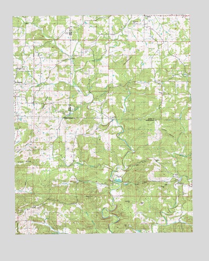
Sandtown, AR USGS Topographic Map
Click on map above to begin viewing in our Map Viewer.

This topographic map contains these locations and features:
Feature Name Type Latitude Longitude GNIS ID View Map
Adler-Southard MineMineN35.9123°W91.6632°81393View Map
Alvis (historical)Populated PlaceN35.9390°W91.7174°67972View Map
Aydelotte WasherLocaleN35.8756°W91.7204°45991View Map
Barnett MineMineN35.8887°W91.6657°81397View Map
Barren ForkStreamN35.9598°W91.7074°45732View Map
Barren Fork ChurchChurchN35.9701°W91.7446°46121View Map
Beatty HollowValleyN35.9029°W91.6751°46255View Map
Beatty PondReservoirN35.9033°W91.6722°75636View Map
Bell HillSummitN35.8792°W91.6718°57355View Map
Bell Hill ProspectMineN35.8798°W91.6710°81399View Map
Big HollowValleyN35.9126°W91.6721°46563View Map
Blue RidgeRidgeN35.8917°W91.7324°46759View Map
Blue Ridge MineMineN35.8920°W91.7238°81402View Map
Bone ProspectMineN35.9581°W91.7449°81537View Map
Brushy BranchStreamN35.8992°W91.6826°47054View Map
C C Johnson ProspectMineN35.8981°W91.7010°81407View Map
C W Maxfield ProspectMineN35.8867°W91.7232°81408View Map
Chapel HillSummitN35.9009°W91.6443°57539View Map
Chapel Hill MineMineN35.9020°W91.6446°81412View Map
Clark CemeteryCemeteryN35.9034°W91.6871°47800View Map
Clark HillSummitN35.8917°W91.6621°57553View Map
Conyers CemeteryCemeteryN35.9445°W91.7162°47969View Map
Conyers CemeteryCemeteryN35.9667°W91.6979°47970View Map
Conyers Spring SchoolSchoolN35.9651°W91.7318°47971View Map
Coon CreekStreamN35.8790°W91.6440°47998View Map
Cooper HollowValleyN35.9601°W91.7271°48013View Map
Cripple Hill ProspectMineN35.9009°W91.7363°81415View Map
Dead Tree HillSummitN35.8970°W91.6663°81418View Map
Dead Tree Hill ProspectMineN35.8970°W91.6660°81419View Map
Dishwater BranchStreamN35.9109°W91.6801°48524View Map
Dry CreekStreamN35.9065°W91.6326°48647View Map
Eutopia ChurchChurchN35.9548°W91.6454°76886View Map
Fall HillSummitN35.8798°W91.6601°57743View Map
Friday ProspectMineN35.9051°W91.7232°81432View Map
G W W Patterson ProspectMineN35.8773°W91.6732°81434View Map
Galloway HillSummitN35.8926°W91.6690°57789View Map
Galloway MineMineN35.8956°W91.6654°81435View Map
Grub Cut MineMineN35.8917°W91.7435°81437View Map
Hackley BranchStreamN35.9517°W91.6949°49752View Map
Helms ProspectMineN35.9092°W91.7418°81442View Map
Henry King ProspectMineN35.9584°W91.7476°81553View Map
Kimmer MineMineN35.8754°W91.7310°81458View Map
Kirk CemeteryCemeteryN35.9890°W91.6818°50880View Map
Klondike MineMineN35.8870°W91.7474°81459View Map
KZLE-FM (Batesville)TowerN35.8906°W91.7335°85364View Map
Lassiter MineMineN35.9012°W91.7418°81460View Map
Lees ChapelChurchN35.9026°W91.6424°77467View Map
Liberty SchoolSchoolN35.9765°W91.6940°51123View Map
Lower Bone SchoolSchoolN35.9906°W91.7404°51496View Map
Martins Store (historical)LocaleN35.9506°W91.7024°77606View Map
Maxfield ProspectMineN35.9034°W91.7279°81466View Map
Miller ProngStreamN35.9642°W91.6251°52069View Map
Montgomery BranchStreamN35.9198°W91.6346°52137View Map
Montgomery ChapelChurchN35.9056°W91.6818°52138View Map
Montgomery HillSummitN35.9098°W91.6651°58208View Map
Montgomery Hill MineMineN35.9037°W91.6540°81471View Map
Montgomery MineMineN35.9012°W91.6613°52140View Map
Montgomery ProspectMineN35.9009°W91.6751°81472View Map
Mount Carmel CemeteryCemeteryN35.9948°W91.6650°52272View Map
Napoleon HillSummitN35.8959°W91.6982°58240View Map
Peter Martin HillSummitN35.9742°W91.6688°53301View Map
Pine BranchStreamN35.9492°W91.6974°53405View Map
Pine Hill SchoolSchoolN35.9201°W91.7174°53441View Map
Pleasant Valley SchoolSchoolN35.9445°W91.6890°53622View Map
Polk Southard MinesMineN35.8954°W91.7363°53664View Map
Pool ChapelChurchN35.9079°W91.6382°53685View Map
Pool ProspectMineN35.9090°W91.6454°81481View Map
Pritchett ProspectMineN35.8981°W91.7038°81482View Map
Providence ChurchChurchN35.9409°W91.6821°53830View Map
Reed MineMineN35.8979°W91.6963°81485View Map
Roach MineMineN35.9023°W91.6682°81486View Map
Rocky BranchStreamN35.8809°W91.6349°54131View Map
Rogers MineMineN35.8920°W91.7418°81488View Map
Roseborough MineMineN35.8765°W91.7290°81489View Map
Rowe Field MineMineN35.8904°W91.7238°81490View Map
Saint Pauls ChurchChurchN35.9806°W91.7004°54460View Map
SandtownPopulated PlaceN35.9048°W91.6351°54561View Map
Section 34 ProspectMineN35.9059°W91.7232°81501View Map
Shaw CemeteryCemeteryN35.9903°W91.7132°54744View Map
Sidney CreekStreamN35.9676°W91.7063°54840View Map
Simpson ProspectMineN35.9098°W91.7418°81507View Map
Sis Clark Corner ProspectMineN35.8967°W91.6643°81508View Map
Sis Clark MineMineN35.8954°W91.6615°81509View Map
Southern HillSummitN35.8890°W91.7443°58661View Map
Southern MineMineN35.8904°W91.7443°81511View Map
Tate SpringSpringN35.8752°W91.7201°55444View Map
Thompson SchoolSchoolN35.8842°W91.6338°55549View Map
Township of Barren ForkCivilN35.9634°W91.7422°66694View Map
Township of JeffersonCivilN35.9084°W91.6786°68769View Map
Township of Johnson (historical)CivilN35.9709°W91.7001°69142View Map
Township of West SullivanCivilN35.9816°W91.6649°69159View Map
Turner MineMineN35.8954°W91.7324°81517View Map
United States Mag Corp LakeReservoirN35.9030°W91.6730°79874View Map
United States Mag Corp Lake DamDamN35.9034°W91.6735°79873View Map
Watkins BranchStreamN35.9384°W91.6776°56099View Map
Wildcat HollowValleyN35.9284°W91.6351°56365View Map
Wolf SchoolSchoolN35.9173°W91.6599°56500View Map
Wren MineMineN35.8954°W91.7393°81531View Map

Note: Coordinates in the location and feature list above are referenced to NAD83 datum.


Copyright (C) 2008-2025 Ryan Niemi / Sunset Dynamics ... All Rights Reserved