TopoQuest Logo
Do you find TopoQuest useful?
Help keep TopoQuest running and adding new maps/features by donating!
Bitcoin:  19c7KJd3qBynnjoSw5npx9KScwjBe4ifkT
Litecoin:  LXs6TkuXGGXo1vDsWCkWVdjQX94eUKd6ui
Home View Maps Find Maps Find Places Resources & Links


Wabash Island, Kentucky Topographic Map

USGS Map Title: Wabash Island, KY
USGS Map MRC: 37088G1
DRG (GeoTIFF) Download: o37088g1.tif


Neighboring USGS Topographic Map Quads:


  New Haven, IL  
37088H2
 

  Emma, IL  
37088H1
 

  Mount Vernon, IN  
37087H8
 

  New Haven SW, IL  
37088G2
 

  Wabash Island, KY  
37088G1
 

  Uniontown, KY  
37087G8
 

  Shawneetown, IL  
37088F2
 

  Grove Center, KY  
37088F1
 

  Morganfield, KY  
37087F8


Map MRC Location:

N38°
W89°
N38°
W88°
H8 H7 H6 H5 H4 H3 H2 H1
G8 G7 G6 G5 G4 G3 G2 G1
F8 F7 F6 F5 F4 F3 F2 F1
E8 E7 E6 E5 E4 E3 E2 E1
D8 D7 D6 D5 D4 D3 D2 D1
C8 C7 C6 C5 C4 C3 C2 C1
B8 B7 B6 B5 B4 B3 B2 B1
A8 A7 A6 A5 A4 A3 A2 A1
N37°
W89°
N37°
W88°

Wabash Island, KY USGS 1:24K Topographic Map Preview:
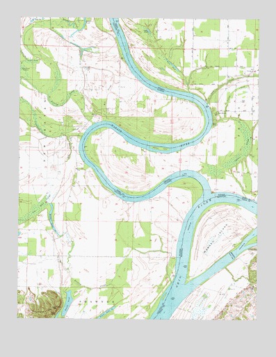
Wabash Island, KY USGS Topographic Map
Click on map above to begin viewing in our Map Viewer.

This topographic map contains these locations and features:
Feature Name Type Latitude Longitude GNIS ID View Map
Beaver PondLakeN37.8703°W88.0929°404066View Map
Berdick SloughGutN37.8639°W88.0917°404202View Map
Black SchoolSchoolN37.8537°W88.0031°431145View Map
Bone BankLeveeN37.8320°W88.0239°431314View Map
Cypress SloughGutN37.8220°W88.0059°433278View Map
Fehrer LakeLakeN37.7515°W88.0798°408312View Map
Goose PondLakeN37.8695°W88.0574°435204View Map
Goose Pond ScattersSwampN37.8523°W88.1220°409186View Map
Grinnel SloughGutN37.8734°W88.0995°409518View Map
Hulda LakeLakeN37.7924°W88.1077°410666View Map
Levy SloughStreamN37.8398°W88.0270°437799View Map
Long PondLakeN37.7503°W88.1044°412599View Map
Mackeys IslandIslandN37.8209°W88.0509°438461View Map
Mill SloughGutN37.8192°W88.0984°413559View Map
Mill SloughGutN37.8420°W88.0795°413560View Map
Oak GrovePopulated PlaceN37.8362°W88.0217°440399View Map
Reburn ChurchChurchN37.7631°W88.0145°501638View Map
Reyburn (historical)Populated PlaceN37.7639°W88.0136°2743589View Map
Round PondLakeN37.7563°W88.0986°416998View Map
Rowe CemeteryCemeteryN37.8409°W88.0095°442363View Map
Running SloughGutN37.8403°W88.1014°417040View Map
Running SloughStreamN37.7650°W88.0448°417042View Map
Sibley CreekStreamN37.7795°W88.0056°503484View Map
Slim PondLakeN37.8561°W88.0458°443607View Map
Township of New HavenCivilN37.8343°W88.1057°429436View Map
Wabash IslandIslandN37.7859°W88.0178°506077View Map
Wabash RiverStreamN37.7981°W88.0273°449850View Map
Willow Pond SloughSwampN37.8045°W88.1078°421262View Map
Yellowbank SloughSwampN37.8319°W88.1160°421571View Map

Note: Coordinates in the location and feature list above are referenced to NAD83 datum.


Copyright (C) 2008-2024 Ryan Niemi / Sunset Dynamics ... All Rights Reserved