TopoQuest Logo
Do you find TopoQuest useful?
Help keep TopoQuest running and adding new maps/features by donating!
Bitcoin:  19c7KJd3qBynnjoSw5npx9KScwjBe4ifkT
Litecoin:  LXs6TkuXGGXo1vDsWCkWVdjQX94eUKd6ui
Home View Maps Find Maps Find Places Resources & Links


Mount Willing, Alabama Topographic Map

USGS Map Title: Mount Willing, AL
USGS Map MRC: 32086A6
DRG (GeoTIFF) Download: o32086a6.tif


Neighboring USGS Topographic Map Quads:


  Collirene, AL  
32086B7
 

  Gordonsville, AL  
32086B6
 

  Hayneville, AL  
32086B5
 

  Braggs, AL  
32086A7
 

  Mount Willing, AL  
32086A6
 

  Calhoun, AL  
32086A5
 

  Ridgeville, AL  
31086H7
 

  Fort Dale, AL  
31086H6
 

  Fort Deposit, AL  
31086H5


Map MRC Location:

N33°
W87°
N33°
W86°
H8 H7 H6 H5 H4 H3 H2 H1
G8 G7 G6 G5 G4 G3 G2 G1
F8 F7 F6 F5 F4 F3 F2 F1
E8 E7 E6 E5 E4 E3 E2 E1
D8 D7 D6 D5 D4 D3 D2 D1
C8 C7 C6 C5 C4 C3 C2 C1
B8 B7 B6 B5 B4 B3 B2 B1
A8 A7 A6 A5 A4 A3 A2 A1
N32°
W87°
N32°
W86°

Mount Willing, AL USGS 1:24K Topographic Map Preview:
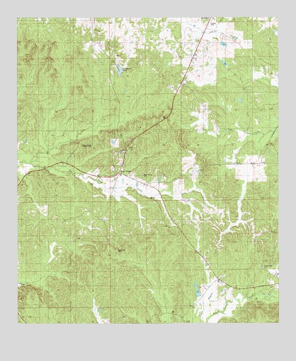
Mount Willing, AL USGS Topographic Map
Click on map above to begin viewing in our Map Viewer.

This topographic map contains these locations and features:
Feature Name Type Latitude Longitude GNIS ID View Map
Antioch Baptist ChurchChurchN32.0718°W86.6969°136312View Map
Beechwood Airport (historical)AirportN32.1168°W86.6500°129419View Map
Dan S Hagood LakeReservoirN32.1166°W86.6454°130158View Map
Dan S Hagood Lake DamDamN32.1151°W86.6450°130157View Map
Garrett Mill Church (historical)ChurchN32.0982°W86.7308°136357View Map
H W Moore LakeReservoirN32.0168°W86.6600°130058View Map
H W Moore Lake DamDamN32.0168°W86.6600°130059View Map
HammondDamN32.1035°W86.6883°130143View Map
Hammond PondLakeN32.1037°W86.7008°136366View Map
Lee CemeteryCemeteryN32.0604°W86.6808°136380View Map
Llano Grove Church (historical)ChurchN32.0463°W86.7166°136384View Map
LumPopulated PlaceN32.0660°W86.6508°156638View Map
Lum School (historical)SchoolN32.0654°W86.6330°136390View Map
Mount Carmel Church (historical)ChurchN32.1149°W86.7411°136408View Map
Mount Olive Church (historical)ChurchN32.1215°W86.6366°136414View Map
Mount WillingPopulated PlaceN32.0601°W86.7014°123417View Map
Mount Willing CemeteryCemeteryN32.0607°W86.6903°136417View Map
Mount Willing ChurchChurchN32.0713°W86.6986°163497View Map
Mount Willing ChurchChurchN32.0701°W86.6980°136418View Map
Mount Willing Lookout TowerTowerN32.0732°W86.7189°164458View Map
Snow Hill Christian ChurchChurchN32.0701°W86.7014°163502View Map
Temple Gate CemeteryCemeteryN32.0299°W86.7025°136461View Map
Temple Gate CemeteryCemeteryN32.0232°W86.6325°136462View Map
Temple Gate Church (historical)ChurchN32.0318°W86.6483°136463View Map
Tolbert ChapelChurchN32.0004°W86.6694°164190View Map

Note: Coordinates in the location and feature list above are referenced to NAD83 datum.


Copyright (C) 2008-2024 Ryan Niemi / Sunset Dynamics ... All Rights Reserved