TopoQuest Logo
Do you find TopoQuest useful?
Help keep TopoQuest running and adding new maps/features by donating!
Bitcoin:  19c7KJd3qBynnjoSw5npx9KScwjBe4ifkT
Litecoin:  LXs6TkuXGGXo1vDsWCkWVdjQX94eUKd6ui
Home View Maps Find Maps Find Places Resources & Links


Braggs, Alabama Topographic Map

USGS Map Title: Braggs, AL
USGS Map MRC: 32086A7
DRG (GeoTIFF) Download: o32086a7.tif


Neighboring USGS Topographic Map Quads:


  Pleasant Hill, AL  
32086B8
 

  Collirene, AL  
32086B7
 

  Gordonsville, AL  
32086B6
 

  Minter, AL  
32086A8
 

  Braggs, AL  
32086A7
 

  Mount Willing, AL  
32086A6
 

  Pine Apple North, AL  
31086H8
 

  Ridgeville, AL  
31086H7
 

  Fort Dale, AL  
31086H6


Map MRC Location:

N33°
W87°
N33°
W86°
H8 H7 H6 H5 H4 H3 H2 H1
G8 G7 G6 G5 G4 G3 G2 G1
F8 F7 F6 F5 F4 F3 F2 F1
E8 E7 E6 E5 E4 E3 E2 E1
D8 D7 D6 D5 D4 D3 D2 D1
C8 C7 C6 C5 C4 C3 C2 C1
B8 B7 B6 B5 B4 B3 B2 B1
A8 A7 A6 A5 A4 A3 A2 A1
N32°
W87°
N32°
W86°

Braggs, AL USGS 1:24K Topographic Map Preview:
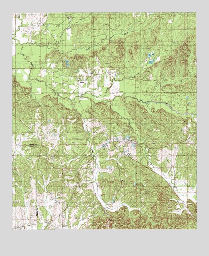
Braggs, AL USGS Topographic Map
Click on map above to begin viewing in our Map Viewer.

This topographic map contains these locations and features:
Feature Name Type Latitude Longitude GNIS ID View Map
BraggsPopulated PlaceN32.0504°W86.7955°114820View Map
Braggs ChurchChurchN32.0518°W86.8003°136328View Map
Braggs Store Post Office (historical)Post OfficeN32.0496°W86.7966°166060View Map
Camp CreekStreamN32.0768°W86.8278°115452View Map
Container Corporation LakeReservoirN32.0618°W86.7950°130097View Map
Container Corporation Lake DamDamN32.0618°W86.7950°130098View Map
Crossroad CemeteryCemeteryN32.0482°W86.7619°116896View Map
Crossroads Church (historical)ChurchN32.0490°W86.7616°136343View Map
Crum CemeteryCemeteryN32.0029°W86.8675°116929View Map
Drane (historical)LocaleN32.1190°W86.7636°136347View Map
Dutch Bend SchoolSchoolN32.0085°W86.8330°117697View Map
Florence Cabiniss LakeReservoirN32.0949°W86.8373°130126View Map
Florence Cabiniss Lake DamDamN32.0951°W86.8366°130127View Map
FostoriaPopulated PlaceN32.0865°W86.8300°118540View Map
Four Oaks School (historical)SchoolN32.0918°W86.8178°136354View Map
Godwin School (historical)SchoolN32.0249°W86.8380°136359View Map
Green BranchStreamN32.1054°W86.8514°119330View Map
Haynes CreekStreamN32.0738°W86.8078°155093View Map
Middle CreekStreamN32.0738°W86.8355°122683View Map
Mosses DivisionCivilN32.0910°W86.7766°165854View Map
Mount Clair ChurchChurchN32.0526°W86.7558°163494View Map
Mount Clair SchoolSchoolN32.0810°W86.7611°123183View Map
Mount Clear ChurchChurchN32.0796°W86.7625°136409View Map
New Bethel CemeteryCemeteryN32.0596°W86.8130°123713View Map
New Bethel ChurchChurchN32.0507°W86.7980°136420View Map
New Salem ChurchChurchN32.0560°W86.8130°152675View Map
Oak Grove ChurchChurchN32.0376°W86.8522°124083View Map
Oliver CemeteryCemeteryN32.0549°W86.8547°124281View Map
Pine Flat Baptist ChurchChurchN32.0921°W86.8441°136428View Map
Pine Flat SchoolSchoolN32.0960°W86.8414°124769View Map
Quailwood Farms LakesReservoirN32.0949°W86.8373°136436View Map
Sills CemeteryCemeteryN32.0535°W86.8686°136455View Map
Sullivan BranchStreamN32.1065°W86.8686°127514View Map
Sullivan CreekStreamN32.1171°W86.8358°127515View Map
White Lily ChurchChurchN32.0901°W86.8019°128878View Map
Wood SchoolSchoolN32.1229°W86.8514°129182View Map
Zion Chapel ChurchChurchN32.0076°W86.8319°136474View Map

Note: Coordinates in the location and feature list above are referenced to NAD83 datum.


Copyright (C) 2008-2024 Ryan Niemi / Sunset Dynamics ... All Rights Reserved