TopoQuest Logo
Do you find TopoQuest useful?
Help keep TopoQuest running and adding new maps/features by donating!
Bitcoin:  19c7KJd3qBynnjoSw5npx9KScwjBe4ifkT
Litecoin:  LXs6TkuXGGXo1vDsWCkWVdjQX94eUKd6ui
Home View Maps Find Maps Find Places Resources & Links


Mount Zion, Iowa Topographic Map

USGS Map Title: Mount Zion, IA
USGS Map MRC: 40091G8
DRG (GeoTIFF) Download: o40091g8.tif


Neighboring USGS Topographic Map Quads:


  Libertyville, IA  
40092H1
 

  Fairfield South, IA  
40091H8
 

  Lockridge West, IA  
40091H7
 

  Douds, IA  
40092G1
 

  Mount Zion, IA  
40091G8
 

  Stockport, IA  
40091G7
 

  Cantril, IA  
40092F1
 

  Keosauqua, IA  
40091F8
 

  Bonaparte, IA  
40091F7


Map MRC Location:

N41°
W92°
N41°
W91°
H8 H7 H6 H5 H4 H3 H2 H1
G8 G7 G6 G5 G4 G3 G2 G1
F8 F7 F6 F5 F4 F3 F2 F1
E8 E7 E6 E5 E4 E3 E2 E1
D8 D7 D6 D5 D4 D3 D2 D1
C8 C7 C6 C5 C4 C3 C2 C1
B8 B7 B6 B5 B4 B3 B2 B1
A8 A7 A6 A5 A4 A3 A2 A1
N40°
W92°
N40°
W91°

Mount Zion, IA USGS 1:24K Topographic Map Preview:
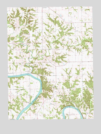
Mount Zion, IA USGS Topographic Map
Click on map above to begin viewing in our Map Viewer.

This topographic map contains these locations and features:
Feature Name Type Latitude Longitude GNIS ID View Map
Anson CemeteryCemeteryN40.7570°W91.9154°1980996View Map
Austin County ParkParkN40.7686°W91.9680°463874View Map
County Farm CemeteryCemeteryN40.7667°W91.9377°1981009View Map
Forbes CemeteryCemeteryN40.7733°W91.9394°1823554View Map
Gilbert CemeteryCemeteryN40.7917°W91.9780°1981012View Map
KilbournPopulated PlaceN40.8061°W91.9699°458070View Map
Kilbourn (historical)LocaleN40.8022°W91.9696°1980886View Map
Kilbourn Post Office (historical)Post OfficeN40.8061°W91.9699°1980887View Map
Kilbourne CemeteryCemeteryN40.8047°W91.9704°1981013View Map
Leech CemeteryCemeteryN40.7839°W91.9780°1823553View Map
Lick CreekStreamN40.7995°W91.9552°458336View Map
Little CreekStreamN40.8439°W91.9796°458460View Map
Little Lick CreekStreamN40.8197°W91.9632°458478View Map
Miller CemeteryCemeteryN40.8045°W91.8907°1823552View Map
Mount ZionPopulated PlaceN40.7886°W91.9338°459350View Map
Mount Zion (historical)LocaleN40.7886°W91.9338°1980871View Map
Mount Zion ChurchChurchN40.7986°W91.9302°1823555View Map
Mount Zion Post Office (historical)Post OfficeN40.7886°W91.9338°1980870View Map
Parkerville CemeteryCemeteryN40.8667°W91.9002°1981016View Map
Parksville (historical)Populated PlaceN40.8689°W91.9271°465340View Map
Railroad GraveCemeteryN40.7678°W91.9047°1981008View Map
Rider CemeteryCemeteryN40.7667°W91.9780°1981010View Map
Rock CreekStreamN40.7648°W91.8971°460709View Map
Rogers CemeteryCemeteryN40.7917°W91.8891°1980994View Map
Tedrow CemeteryCemeteryN40.8500°W91.9252°1981041View Map
Topping CemeteryCemeteryN40.8500°W91.8835°1981014View Map
Township of UnionCivilN40.8573°W91.8912°468843View Map
Township of Van BurenCivilN40.7639°W91.9880°468858View Map
Union Post Office (historical)Post OfficeN40.8222°W91.8835°1980878View Map
Van Buren CountyCivilN40.7532°W91.9500°465277View Map
Van Buren County HomeBuildingN40.7664°W91.9374°463390View Map
Wilson CemeteryCemeteryN40.7917°W91.9585°1981011View Map
WinchesterPopulated PlaceN40.8503°W91.8999°463121View Map
Winchester CemeteryCemeteryN40.8502°W91.9047°1981015View Map
Winchester Post Office (historical)Post OfficeN40.8503°W91.8999°1980869View Map

Note: Coordinates in the location and feature list above are referenced to NAD83 datum.


Copyright (C) 2008-2025 Ryan Niemi / Sunset Dynamics ... All Rights Reserved