TopoQuest Logo
Do you find TopoQuest useful?
Help keep TopoQuest running and adding new maps/features by donating!
Bitcoin:  19c7KJd3qBynnjoSw5npx9KScwjBe4ifkT
Litecoin:  LXs6TkuXGGXo1vDsWCkWVdjQX94eUKd6ui
Home View Maps Find Maps Find Places Resources & Links


Navajo Lake, Utah Topographic Map

USGS Map Title: Navajo Lake, UT
USGS Map MRC: 37112E7
DRG (GeoTIFF) Download: o37112e7.tif


Neighboring USGS Topographic Map Quads:


  Flanigan Arch, UT  
37112F8
 

  Brian Head, UT  
37112F7
 

  Panguitch Lake, UT  
37112F6
 

  Webster Flat, UT  
37112E8
 

  Navajo Lake, UT  
37112E7
 

  Henrie Knolls, UT  
37112E6
 

  Cogswell Point, UT  
37112D8
 

  Straight Canyon, UT  
37112D7
 

  Strawberry Point, UT  
37112D6


Map MRC Location:

N38°
W113°
N38°
W112°
H8 H7 H6 H5 H4 H3 H2 H1
G8 G7 G6 G5 G4 G3 G2 G1
F8 F7 F6 F5 F4 F3 F2 F1
E8 E7 E6 E5 E4 E3 E2 E1
D8 D7 D6 D5 D4 D3 D2 D1
C8 C7 C6 C5 C4 C3 C2 C1
B8 B7 B6 B5 B4 B3 B2 B1
A8 A7 A6 A5 A4 A3 A2 A1
N37°
W113°
N37°
W112°

Navajo Lake, UT USGS 1:24K Topographic Map Preview:
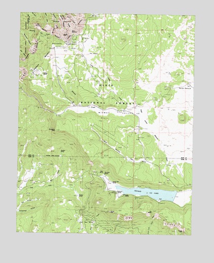
Navajo Lake, UT USGS Topographic Map
Click on map above to begin viewing in our Map Viewer.

This topographic map contains these locations and features:
Feature Name Type Latitude Longitude GNIS ID View Map
Andy Nelson PeakSummitN37.5175°W112.8177°1781948View Map
Arch CanyonValleyN37.6247°W112.8494°1448083View Map
Blowhard MountainSummitN37.5944°W112.8613°1438922View Map
Boy Scout SpringSpringN37.5347°W112.8141°1448172View Map
Bristlecone CanyonValleyN37.6241°W112.8447°1439123View Map
Cascade FallsFallsN37.5021°W112.7570°1439505View Map
Cedar Breaks LodgeLocaleN37.6080°W112.8411°1439557View Map
Cedar Breaks Visitor CenterLocaleN37.6133°W112.8377°1448244View Map
Christensen Boating SiteLocaleN37.5225°W112.7886°1451211View Map
Cox HollowValleyN37.5130°W112.8747°1440105View Map
Deer HollowValleyN37.5433°W112.7980°1449870View Map
Deer ValleyValleyN37.5397°W112.7691°1440382View Map
Elderberry SpringSpringN37.5227°W112.8036°1440887View Map
Gooseberry PointSummitN37.5580°W112.8488°1448431View Map
Horse PastureFlatN37.5847°W112.7627°1441892View Map
Jericho CanyonValleyN37.6250°W112.8494°1442130View Map
Jericho RidgeRidgeN37.6194°W112.8424°1442131View Map
Larson SpringSpringN37.5220°W112.7987°1448578View Map
Lava DesertPlainN37.5866°W112.7641°1451282View Map
Long Valley CreekStreamN37.5691°W112.7891°1442936View Map
Lundale SpringSpringN37.5905°W112.8591°1448630View Map
Meadow SpringSpringN37.5216°W112.8324°1443285View Map
Midway ValleyValleyN37.5691°W112.7972°1443383View Map
Mill CreekStreamN37.5264°W112.8569°1443419View Map
Navajo LakeReservoirN37.5231°W112.7754°1443765View Map
Navajo Lake CampgroundLocaleN37.5205°W112.7899°1451307View Map
Navajo lake LodgePopulated PlaceN37.5203°W112.8036°1451308View Map
Navajo Lake SpringSpringN37.5293°W112.8080°1448729View Map
Navajo PeakSummitN37.5125°W112.8091°1448731View Map
Olsen SpringSpringN37.5343°W112.8136°1448777View Map
Point SupremeCapeN37.6150°W112.8386°1444497View Map
Point Supreme CampgroundLocaleN37.6105°W112.8313°1448861View Map
Sage ValleyValleyN37.5539°W112.7769°1445247View Map
Simpkins SpringSpringN37.5465°W112.8454°1445606View Map
Slip CanyonValleyN37.6178°W112.8505°1445694View Map
Spectra PointCapeN37.6047°W112.8444°1445952View Map
Spruces CampgroundLocaleN37.5178°W112.7741°1449055View Map
Square ArchArchN37.6191°W112.8369°1679061View Map
Sunset ViewLocaleN37.6208°W112.8286°1449086View Map
Te-ah CampgroundLocaleN37.5341°W112.8186°1451363View Map
The BartizanSummitN37.6183°W112.8641°1433258View Map
The CratersCraterN37.6047°W112.8205°1446435View Map
The SaddleGapN37.5139°W112.7783°1446500View Map
Upper Bear SpringsSpringN37.5049°W112.8219°1446850View Map
Wasatch RampartCliffN37.6125°W112.8522°1447007View Map
Zion Canyon ViewLocaleN37.5705°W112.8591°1447585View Map

Note: Coordinates in the location and feature list above are referenced to NAD83 datum.


Copyright (C) 2008-2024 Ryan Niemi / Sunset Dynamics ... All Rights Reserved