TopoQuest Logo
Do you find TopoQuest useful?
Help keep TopoQuest running and adding new maps/features by donating!
Bitcoin:  19c7KJd3qBynnjoSw5npx9KScwjBe4ifkT
Litecoin:  LXs6TkuXGGXo1vDsWCkWVdjQX94eUKd6ui
Home View Maps Find Maps Find Places Resources & Links


Mineral, Illinois Topographic Map

USGS Map Title: Mineral, IL
USGS Map MRC: 41089D7
DRG (GeoTIFF) Download: o41089d7.tif


Neighboring USGS Topographic Map Quads:


  Hooppole, IL  
41089E8
 

  Yorktown, IL  
41089E7
 

  New Bedford, IL  
41089E6
 

  Annawan, IL  
41089D8
 

  Mineral, IL  
41089D7
 

  Manlius, IL  
41089D6
 

  Kewanee North, IL  
41089C8
 

  Neponset, IL  
41089C7
 

  Buda, IL  
41089C6


Map MRC Location:

N42°
W90°
N42°
W89°
H8 H7 H6 H5 H4 H3 H2 H1
G8 G7 G6 G5 G4 G3 G2 G1
F8 F7 F6 F5 F4 F3 F2 F1
E8 E7 E6 E5 E4 E3 E2 E1
D8 D7 D6 D5 D4 D3 D2 D1
C8 C7 C6 C5 C4 C3 C2 C1
B8 B7 B6 B5 B4 B3 B2 B1
A8 A7 A6 A5 A4 A3 A2 A1
N41°
W90°
N41°
W89°

Mineral, IL USGS 1:24K Topographic Map Preview:
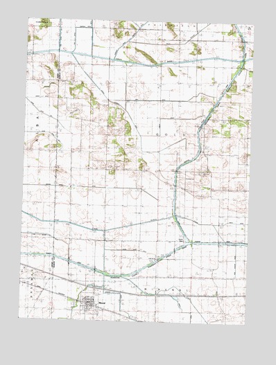
Mineral, IL USGS Topographic Map
Click on map above to begin viewing in our Map Viewer.

This topographic map contains these locations and features:
Feature Name Type Latitude Longitude GNIS ID View Map
Abbott DitchCanalN41.3811°W89.7851°403315View Map
Baker DitchCanalN41.4673°W89.8671°1747345View Map
Barbara DitchCanalN41.3756°W89.8101°1720959View Map
Bureau County DitchCanalN41.4686°W89.8312°405212View Map
Coal CreekStreamN41.3945°W89.8193°406292View Map
Conley DitchCanalN41.4600°W89.7965°1720967View Map
Conley School (historical)SchoolN41.4600°W89.7526°406474View Map
Etheridge Airport (historical)AirportN41.4750°W89.8534°427542View Map
Fairfield Ditch Number 3CanalN41.4914°W89.8382°1720974View Map
Feeder BasinBasinN41.4100°W89.7840°408309View Map
Gold Township CemeteryCemeteryN41.4351°W89.7859°1822656View Map
Goose Pond DitchCanalN41.4048°W89.8109°1720978View Map
Graham DitchCanalN41.4723°W89.8615°1747378View Map
Gray DitchCanalN41.4675°W89.7907°1720979View Map
Hickory CreekStreamN41.4161°W89.8565°410143View Map
Hunt SloughStreamN41.4920°W89.8195°410693View Map
Johnson School (historical)SchoolN41.4314°W89.7720°411177View Map
King CreekStreamN41.3942°W89.8184°411490View Map
Lawson CreekStreamN41.3873°W89.7984°411876View Map
Lock Number 22DamN41.4009°W89.7982°425131View Map
MineralPopulated PlaceN41.3825°W89.8365°413640View Map
Mineral - Gold Fire Protection DistrictBuildingN41.3827°W89.8375°2640890View Map
Mineral Marsh DitchCanalN41.4311°W89.8493°413642View Map
Mineral Post OfficePost OfficeN41.3819°W89.8357°2788461View Map
Pleasant Ridge School (historical)SchoolN41.4817°W89.7809°415891View Map
Roe DitchCanalN41.4917°W89.8484°1721014View Map
Roe Ditch Number 2CanalN41.4995°W89.8398°1721015View Map
Township of GoldCivilN41.4527°W89.7997°429057View Map
Trading House School (historical)SchoolN41.4595°W89.8465°419815View Map
Village of MineralCivilN41.3843°W89.8388°2399370View Map

Note: Coordinates in the location and feature list above are referenced to NAD83 datum.


Copyright (C) 2008-2025 Ryan Niemi / Sunset Dynamics ... All Rights Reserved