TopoQuest Logo
Do you find TopoQuest useful?
Help keep TopoQuest running and adding new maps/features by donating!
Bitcoin:  19c7KJd3qBynnjoSw5npx9KScwjBe4ifkT
Litecoin:  LXs6TkuXGGXo1vDsWCkWVdjQX94eUKd6ui
Home View Maps Find Maps Find Places Resources & Links


New Plymouth, Ohio Topographic Map

USGS Map Title: New Plymouth, OH
USGS Map MRC: 39082D4
DRG (GeoTIFF) Download: o39082d4.tif


Neighboring USGS Topographic Map Quads:


  Rockbridge, OH  
39082E5
 

  Logan, OH  
39082E4
 

  Gore, OH  
39082E3
 

  South Bloomingville, OH  
39082D5
 

  New Plymouth, OH  
39082D4
 

  Union Furnace, OH  
39082D3
 

  Allensville, OH  
39082C5
 

  Zaleski, OH  
39082C4
 

  Mineral, OH  
39082C3


Map MRC Location:

N40°
W83°
N40°
W82°
H8 H7 H6 H5 H4 H3 H2 H1
G8 G7 G6 G5 G4 G3 G2 G1
F8 F7 F6 F5 F4 F3 F2 F1
E8 E7 E6 E5 E4 E3 E2 E1
D8 D7 D6 D5 D4 D3 D2 D1
C8 C7 C6 C5 C4 C3 C2 C1
B8 B7 B6 B5 B4 B3 B2 B1
A8 A7 A6 A5 A4 A3 A2 A1
N39°
W83°
N39°
W82°

New Plymouth, OH USGS 1:24K Topographic Map Preview:
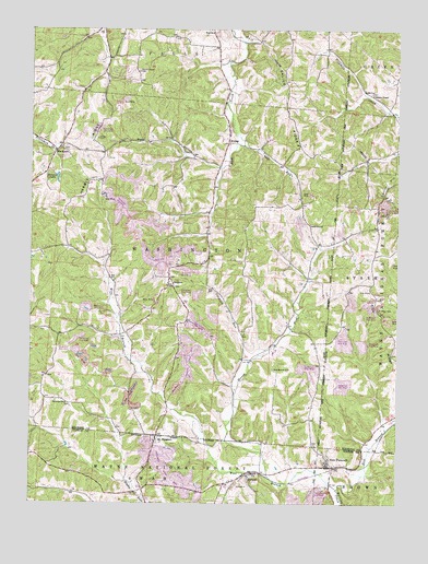
New Plymouth, OH USGS Topographic Map
Click on map above to begin viewing in our Map Viewer.

This topographic map contains these locations and features:
Feature Name Type Latitude Longitude GNIS ID View Map
BlackjackPopulated PlaceN39.4678°W82.4918°1075395View Map
Blackjack CemeteryCemeteryN39.4681°W82.4893°1963569View Map
Blackjack Post Office (historical)Post OfficeN39.4681°W82.4915°2010352View Map
Calico RidgeRidgeN39.4817°W82.4127°1075507View Map
Camp Otterbein LakeReservoirN39.4615°W82.3752°1080471View Map
Carrick HillSummitN39.4612°W82.3790°1075529View Map
Claylick RunStreamN39.4120°W82.4257°1075583View Map
East Branch Raccoon CreekStreamN39.3790°W82.3952°1075767View Map
EwingPopulated PlaceN39.4726°W82.4332°1075818View Map
Ewing CemeteryCemeteryN39.4734°W82.4318°1963577View Map
Ewing Post Office (historical)Post OfficeN39.4723°W82.4332°2009812View Map
Fairview CemeteryCemeteryN39.4012°W82.4877°1963578View Map
Fairview United Brethren ChurchChurchN39.4015°W82.4877°1075827View Map
Goat RunStreamN39.4728°W82.4304°1075932View Map
Harble RidgeRidgeN39.4645°W82.4760°1076005View Map
Hidden LakeReservoirN39.4608°W82.4910°1078050View Map
Hidden Lake DamDamN39.4617°W82.4915°1078049View Map
Hocking CountyCivilN39.4970°W82.4793°1074049View Map
Honey ForkStreamN39.3823°W82.4185°1076071View Map
IlesboroPopulated PlaceN39.4348°W82.4532°1076105View Map
Ilesboro CemeteryCemeteryN39.4323°W82.4510°1963582View Map
Isleboro Post Office (historical)Post OfficeN39.4348°W82.4527°2009847View Map
Meldrim CemeteryCemeteryN39.4489°W82.4054°1076375View Map
Metz HollowValleyN39.4634°W82.4352°1077306View Map
Miller Chapel CemeteryCemeteryN39.4828°W82.3840°1954519View Map
Millers ChapelChurchN39.4826°W82.3835°1077289View Map
Morris ChapelChurchN39.4890°W82.4640°1076435View Map
Morris Chapel CemeteryCemeteryN39.4887°W82.4635°1963587View Map
Mount PleasantPopulated PlaceN39.3928°W82.4568°1076456View Map
Mount Pleasant CemeteryCemeteryN39.3928°W82.4599°1961646View Map
New PlymouthPopulated PlaceN39.3848°W82.3963°1076509View Map
New Plymouth CemeteryCemeteryN39.3903°W82.4029°1961648View Map
Olive Branch CemeteryCemeteryN39.4106°W82.4174°1076571View Map
OrlandPopulated PlaceN39.3828°W82.4238°1076580View Map
Smock (historical)Populated PlaceN39.4087°W82.4943°1067406View Map
Smock Post Office (historical)Post OfficeN39.4084°W82.4943°2009832View Map
Strawn CemeteryCemeteryN39.4714°W82.4773°1076979View Map
Tick RidgeRidgeN39.4237°W82.3796°1077049View Map
Tick Ridge CemeteryCemeteryN39.4260°W82.3816°1077051View Map
Township of WashingtonCivilN39.4375°W82.4542°1086326View Map
Washington Township Volunteer Fire DepartmentBuildingN39.4341°W82.4526°2549957View Map
West Branch Raccoon CreekStreamN39.3790°W82.3954°1077165View Map
Zion ChurchChurchN39.4990°W82.4396°1077253View Map

Note: Coordinates in the location and feature list above are referenced to NAD83 datum.


Copyright (C) 2008-2025 Ryan Niemi / Sunset Dynamics ... All Rights Reserved