TopoQuest Logo
Do you find TopoQuest useful?
Help keep TopoQuest running and adding new maps/features by donating!
Bitcoin:  19c7KJd3qBynnjoSw5npx9KScwjBe4ifkT
Litecoin:  LXs6TkuXGGXo1vDsWCkWVdjQX94eUKd6ui
Home View Maps Find Maps Find Places Resources & Links


South Bloomingville, Ohio Topographic Map

USGS Map Title: South Bloomingville, OH
USGS Map MRC: 39082D5
DRG (GeoTIFF) Download: o39082d5.tif


Neighboring USGS Topographic Map Quads:


  Clearport, OH  
39082E6
 

  Rockbridge, OH  
39082E5
 

  Logan, OH  
39082E4
 

  Laurelville, OH  
39082D6
 

  South Bloomingville, OH  
39082D5
 

  New Plymouth, OH  
39082D4
 

  Ratcliffburg, OH  
39082C6
 

  Allensville, OH  
39082C5
 

  Zaleski, OH  
39082C4


Map MRC Location:

N40°
W83°
N40°
W82°
H8 H7 H6 H5 H4 H3 H2 H1
G8 G7 G6 G5 G4 G3 G2 G1
F8 F7 F6 F5 F4 F3 F2 F1
E8 E7 E6 E5 E4 E3 E2 E1
D8 D7 D6 D5 D4 D3 D2 D1
C8 C7 C6 C5 C4 C3 C2 C1
B8 B7 B6 B5 B4 B3 B2 B1
A8 A7 A6 A5 A4 A3 A2 A1
N39°
W83°
N39°
W82°

South Bloomingville, OH USGS 1:24K Topographic Map Preview:
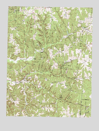
South Bloomingville, OH USGS Topographic Map
Click on map above to begin viewing in our Map Viewer.

This topographic map contains these locations and features:
Feature Name Type Latitude Longitude GNIS ID View Map
Ash Cave Lookout TowerTowerN39.4056°W82.5310°1080028View Map
Ash Cave Picnic AreaLocaleN39.3953°W82.5460°1083369View Map
Ash Cave Recreation AreaParkN39.3956°W82.5452°1082369View Map
Barringer RidgeRidgeN39.4812°W82.6035°1075311View Map
Big HoleValleyN39.4248°W82.5624°1075379View Map
Big Spring HollowValleyN39.4553°W82.5627°1075383View Map
Birley HollowValleyN39.4473°W82.5777°1075386View Map
Blackjack BranchStreamN39.4784°W82.5163°1075396View Map
Blackjack LakeLakeN39.4773°W82.5138°1075397View Map
Blain HollowValleyN39.4645°W82.5410°1075399View Map
Brehm School (historical)SchoolN39.4765°W82.6121°1960292View Map
Brineinger HollowValleyN39.4665°W82.5727°1075443View Map
Buchanan School (historical)SchoolN39.4151°W82.6135°1960294View Map
Burgoon HollowValleyN39.4517°W82.5843°1075483View Map
Camp OtyokwaLocaleN39.4420°W82.5738°1075515View Map
Cedar FallsFallsN39.4195°W82.5235°1075542View Map
Cedar Falls (historical)Populated PlaceN39.4198°W82.5232°1067395View Map
Cedar Falls Picnic AreaLocaleN39.4178°W82.5265°1083368View Map
Cedar GrovePopulated PlaceN39.4378°W82.5396°1075543View Map
Cedar Grove Post Office (historical)Post OfficeN39.4376°W82.5402°2009810View Map
Cedar Grove TrailTrailN39.4292°W82.5371°1075544View Map
Chapel RidgeRidgeN39.4231°W82.5574°1077325View Map
Chapel Ridge TrailTrailN39.4206°W82.5418°1075565View Map
Conkles HollowValleyN39.4545°W82.5746°1075615View Map
Conkles Hollow Picnic AreaLocaleN39.4553°W82.5763°1083366View Map
Conkles Hollow Recreation AreaParkN39.4570°W82.5785°1082368View Map
Conkles Hollow State Nature PreserveParkN39.4570°W82.5760°1960575View Map
Crane HollowValleyN39.4565°W82.5693°1075643View Map
Cream RidgeRidgeN39.4770°W82.5590°1075648View Map
Cream Ridge School (historical)SchoolN39.4767°W82.5577°1960295View Map
Cupp HollowValleyN39.4728°W82.5715°1075662View Map
Denton HollowValleyN39.4565°W82.6016°1075704View Map
Dresbach School (historical)SchoolN39.4409°W82.6004°1960296View Map
Early HollowValleyN39.4795°W82.5929°1075762View Map
East Fork Queer CreekStreamN39.4165°W82.5988°1075770View Map
East Rim TrailTrailN39.4576°W82.5746°1960576View Map
Ebenezer CemeteryCemeteryN39.3812°W82.5052°1961637View Map
Ebenezer ChurchChurchN39.3809°W82.5054°1075776View Map
Ebenezer School (historical)SchoolN39.3790°W82.5038°1051914View Map
Edison HollowValleyN39.4570°W82.5552°1075780View Map
Extine HillRidgeN39.4851°W82.5535°1075820View Map
GibisonvillePopulated PlaceN39.4998°W82.5665°1075914View Map
Gibisonville Post Office (historical)Post OfficeN39.4995°W82.5665°2010351View Map
Gold Mine HollowValleyN39.4762°W82.5932°1075933View Map
Goose CreekStreamN39.4151°W82.6029°1075936View Map
Gorge TrailTrailN39.4570°W82.5760°1960577View Map
Grant-Moore CemeteryCemeteryN39.4992°W82.5977°1075951View Map
Greenbrier School (historical)SchoolN39.3912°W82.6135°1960297View Map
Hadden HollowValleyN39.4323°W82.5471°1075977View Map
Hagley HollowValleyN39.4628°W82.5493°1075981View Map
Hagley Hollow ArchArchN39.4636°W82.5494°1679031View Map
Hamilton HollowValleyN39.4267°W82.5740°1075988View Map
High Rock HollowValleyN39.4048°W82.5621°1076046View Map
Hocking Hills ReservoirReservoirN39.4273°W82.5370°1078052View Map
Hocking Hills Reservoir DamDamN39.4251°W82.5382°1078051View Map
Hocking Hills State ParkParkN39.4306°W82.5388°1082370View Map
Hocking Honor CampLocaleN39.4562°W82.5799°1076058View Map
Hocking State ForestForestN39.4334°W82.5415°1076056View Map
Hocking TrailTrailN39.4226°W82.5371°1076059View Map
Hood HollowValleyN39.4823°W82.5740°1076072View Map
Hoy HollowValleyN39.4195°W82.5227°1076085View Map
HuePopulated PlaceN39.3870°W82.5052°1076086View Map
Huffine HollowValleyN39.4720°W82.5946°1076087View Map
Huffman Unger RidgeRidgeN39.4517°W82.5404°1076088View Map
Hunters RockCliffN39.4687°W82.5360°1076096View Map
Justice CemeteryCemeteryN39.4137°W82.6091°1076160View Map
Keck RidgeRidgeN39.4301°W82.6004°1076167View Map
Kreachbaum RidgeRidgeN39.4909°W82.5410°1076194View Map
Laurelville Fire Department Station 2BuildingN39.4260°W82.5888°2550292View Map
Liberty Hill CemeteryCemeteryN39.3952°W82.5816°1940352View Map
Liberty Hill ChurchChurchN39.3953°W82.5821°1076243View Map
Little Blackjack BranchStreamN39.4695°W82.5288°1076265View Map
Little Rocky BranchStreamN39.4698°W82.5368°1076276View Map
Long HollowValleyN39.4592°W82.5596°1076294View Map
Methodist Episcopal CemeteryCemeteryN39.4992°W82.5649°1963584View Map
Moore HollowValleyN39.4606°W82.5524°1076427View Map
New Zion ChurchChurchN39.4751°W82.5096°1076514View Map
Oak Grove CemeteryCemeteryN39.4723°W82.6115°1077324View Map
Oak Grove School (historical)SchoolN39.3853°W82.5352°1960299View Map
Old Baptist CemeteryCemeteryN39.4902°W82.5974°1076553View Map
Old Mans Cave Recreation AreaParkN39.4345°W82.5421°1082371View Map
Oldfield HollowValleyN39.4278°W82.5785°1076568View Map
Oldfield RidgeRidgeN39.4359°W82.5827°1076569View Map
Parish RocksCliffN39.4223°W82.5572°1076595View Map
Peterson HollowValleyN39.4940°W82.5532°1076625View Map
Pine Grove CemeteryCemeteryN39.4509°W82.5732°1963596View Map
Pine Grove ChurchChurchN39.4509°W82.5735°1076640View Map
Pine School (historical)SchoolN39.4703°W82.5282°1960302View Map
Point Pleasant (historical)Populated PlaceN39.4373°W82.5090°1067403View Map
Prospect CemeteryCemeteryN39.4817°W82.5024°1076689View Map
Pursell (historical)Populated PlaceN39.4406°W82.5999°1067404View Map
Pursell Post Office (historical)Post OfficeN39.4403°W82.5999°2009829View Map
Red Rock HollowValleyN39.4267°W82.5643°1076721View Map
Robison HollowValleyN39.4662°W82.5371°1076750View Map
Rock House Lookout TowerTowerN39.4956°W82.6129°1080179View Map
Rockhouse (historical)Populated PlaceN39.4940°W82.6149°1061271View Map
Rockhouse Post Office (historical)Post OfficeN39.4945°W82.6152°2009830View Map
Rocky BranchStreamN39.4701°W82.5310°1076754View Map
Rooty HollowValleyN39.4251°W82.5599°1076767View Map
Rose HollowValleyN39.4226°W82.5393°1076771View Map
Ryan HollowValleyN39.4692°W82.5982°1076783View Map
Saint John the Baptist CemeteryCemeteryN39.4294°W82.5292°1076794View Map
Saint Johns ChapelChurchN39.4406°W82.5304°1076797View Map
Shaw HollowValleyN39.4190°W82.5999°1076868View Map
Sheick HollowValleyN39.4659°W82.5452°1076878View Map
Silex HollowValleyN39.4642°W82.5693°1076893View Map
Snyder HollowValleyN39.4698°W82.5724°1076928View Map
Sours CemeteryCemeteryN39.4678°W82.6216°1076929View Map
South BloomingvillePopulated PlaceN39.4187°W82.5993°1076930View Map
South Bloomingville CemeteryCemeteryN39.4159°W82.5993°1963603View Map
South Bloomingville Elementary SchoolSchoolN39.4234°W82.5932°1081897View Map
South Bloomingville Post OfficePost OfficeN39.4181°W82.5999°2009846View Map
Spruce RunStreamN39.4398°W82.5993°1076949View Map
The GulfValleyN39.4317°W82.5463°1077039View Map
The Gulf TrailTrailN39.4259°W82.5632°1077040View Map
Township of BentonCivilN39.4158°W82.5719°1086316View Map
Unger HollowValleyN39.4587°W82.5482°1077095View Map
Vickroy HollowValleyN39.4490°W82.5729°1077120View Map
Vorhees School (historical)SchoolN39.4767°W82.5854°1960307View Map
Wesley ChapelChurchN39.4109°W82.5390°1077158View Map
Wesley Chapel CemeteryCemeteryN39.4109°W82.5387°1963607View Map
West Rim TrailTrailN39.4570°W82.5774°1960578View Map
Young HollowValleyN39.4687°W82.5702°1077246View Map

Note: Coordinates in the location and feature list above are referenced to NAD83 datum.


Copyright (C) 2008-2025 Ryan Niemi / Sunset Dynamics ... All Rights Reserved