TopoQuest Logo
Do you find TopoQuest useful?
Help keep TopoQuest running and adding new maps/features by donating!
Bitcoin:  19c7KJd3qBynnjoSw5npx9KScwjBe4ifkT
Litecoin:  LXs6TkuXGGXo1vDsWCkWVdjQX94eUKd6ui
Home View Maps Find Maps Find Places Resources & Links


North Salem, Indiana Topographic Map

USGS Map Title: North Salem, IN
USGS Map MRC: 39086G6
DRG (GeoTIFF) Download: o39086g6.tif


Neighboring USGS Topographic Map Quads:


  Ladoga, IN  
39086H7
 

  New Ross, IN  
39086H6
 

  Lizton, IN  
39086H5
 

  Roachdale, IN  
39086G7
 

  North Salem, IN  
39086G6
 

  Danville, IN  
39086G5
 

  Greencastle, IN  
39086F7
 

  Coatesville, IN  
39086F6
 

  Clayton, IN  
39086F5


Map MRC Location:

N40°
W87°
N40°
W86°
H8 H7 H6 H5 H4 H3 H2 H1
G8 G7 G6 G5 G4 G3 G2 G1
F8 F7 F6 F5 F4 F3 F2 F1
E8 E7 E6 E5 E4 E3 E2 E1
D8 D7 D6 D5 D4 D3 D2 D1
C8 C7 C6 C5 C4 C3 C2 C1
B8 B7 B6 B5 B4 B3 B2 B1
A8 A7 A6 A5 A4 A3 A2 A1
N39°
W87°
N39°
W86°

North Salem, IN USGS 1:24K Topographic Map Preview:
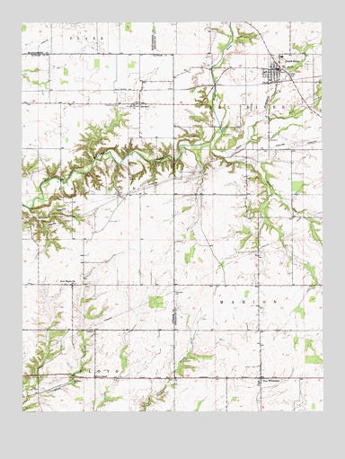
North Salem, IN USGS Topographic Map
Click on map above to begin viewing in our Map Viewer.

This topographic map contains these locations and features:
Feature Name Type Latitude Longitude GNIS ID View Map
Abner - Ragan CemeteryCemeteryN39.8158°W86.6817°2094004View Map
BarnardPopulated PlaceN39.8487°W86.7006°430495View Map
Biddle CemeteryCemeteryN39.8196°W86.7101°431005View Map
Campbell CemeteryCemeteryN39.8614°W86.6347°2093778View Map
Dickerson CemeteryCemeteryN39.8094°W86.6467°2094082View Map
East Fork Big Walnut CreekStreamN39.8362°W86.6714°433883View Map
Eel River Township Fire and RescueBuildingN39.8599°W86.6512°2625884View Map
Fairview CemeteryCemeteryN39.8581°W86.6374°434321View Map
Fleece CemeteryCemeteryN39.8511°W86.6675°2093780View Map
GrovelandPopulated PlaceN39.7606°W86.7200°435532View Map
Groveland CemeteryCemeteryN39.7607°W86.7285°435533View Map
Higgins CemeteryCemeteryN39.7760°W86.6373°2094083View Map
Hunt CreekStreamN39.8206°W86.6458°436614View Map
Middle Fork Big Walnut CreekStreamN39.8364°W86.6711°439093View Map
Mount Olivet ChurchChurchN39.8484°W86.7031°439633View Map
New MaysvillePopulated PlaceN39.7906°W86.7292°440085View Map
New WinchesterPopulated PlaceN39.7606°W86.6508°440127View Map
New Winchester Baptist CemeteryCemeteryN39.7611°W86.6457°2094085View Map
North SalemPopulated PlaceN39.8598°W86.6425°440289View Map
North Salem Baptist CemeteryCemeteryN39.8648°W86.6476°2093785View Map
North Salem Fire DepartmentBuildingN39.8536°W86.6359°2701428View Map
North Salem SchoolSchoolN39.8645°W86.6417°447028View Map
Page CemeteryCemeteryN39.8436°W86.6778°2093786View Map
Ramp RunStreamN39.8328°W86.6647°441755View Map
Richardson CemeteryCemeteryN39.8695°W86.6712°2093788View Map
Robbins CemeteryCemeteryN39.8139°W86.6272°2094087View Map
Roundtown CemeteryCemeteryN39.8292°W86.6503°2093789View Map
Ryner CemeteryCemeteryN39.7628°W86.6780°2094088View Map
Town of North SalemCivilN39.8596°W86.6444°2396823View Map
Township of Eel RiverCivilN39.8716°W86.6355°453274View Map
Township of JacksonCivilN39.8206°W86.7399°453462View Map
Township of MarionCivilN39.7716°W86.6336°453606View Map
Turner CemeteryCemeteryN39.7919°W86.6275°2094092View Map
Turner Farm CemeteryCemeteryN39.7656°W86.6274°2094093View Map
Vannice CemeteryCemeteryN39.8026°W86.6783°2094094View Map
Zimmerman CemeteryCemeteryN39.8611°W86.6722°2093791View Map

Note: Coordinates in the location and feature list above are referenced to NAD83 datum.


Copyright (C) 2008-2025 Ryan Niemi / Sunset Dynamics ... All Rights Reserved