TopoQuest Logo
Do you find TopoQuest useful?
Help keep TopoQuest running and adding new maps/features by donating!
Bitcoin:  19c7KJd3qBynnjoSw5npx9KScwjBe4ifkT
Litecoin:  LXs6TkuXGGXo1vDsWCkWVdjQX94eUKd6ui
Home View Maps Find Maps Find Places Resources & Links


Northeast Palestine, Texas Topographic Map

USGS Map Title: Northeast Palestine, TX
USGS Map MRC: 31095G5
DRG (GeoTIFF) Download: o31095g5.tif


Neighboring USGS Topographic Map Quads:


  Wilkerson Mountain, TX  
31095H6
 

  Pert, TX  
31095H5
 

  Todd City, TX  
31095H4
 

  Northwest Palestine, TX  
31095G6
 

  Northeast Palestine, TX  
31095G5
 

  Neches, TX  
31095G4
 

  Southwest Palestine, TX  
31095F6
 

  Southeast Palestine, TX  
31095F5
 

  Slocum, TX  
31095F4


Map MRC Location:

N32°
W96°
N32°
W95°
H8 H7 H6 H5 H4 H3 H2 H1
G8 G7 G6 G5 G4 G3 G2 G1
F8 F7 F6 F5 F4 F3 F2 F1
E8 E7 E6 E5 E4 E3 E2 E1
D8 D7 D6 D5 D4 D3 D2 D1
C8 C7 C6 C5 C4 C3 C2 C1
B8 B7 B6 B5 B4 B3 B2 B1
A8 A7 A6 A5 A4 A3 A2 A1
N31°
W96°
N31°
W95°

Northeast Palestine, TX USGS 1:24K Topographic Map Preview:
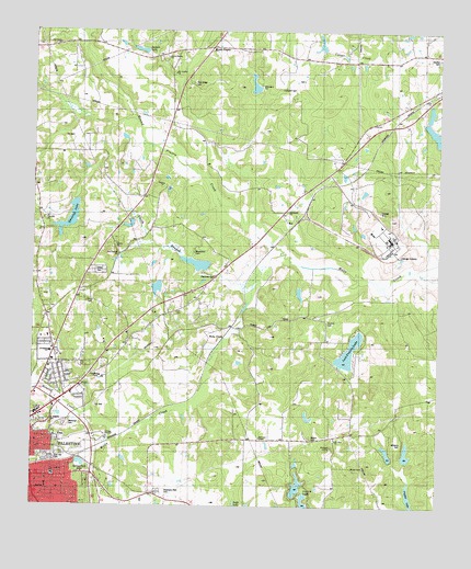
Northeast Palestine, TX USGS Topographic Map
Click on map above to begin viewing in our Map Viewer.

This topographic map contains these locations and features:
Feature Name Type Latitude Longitude GNIS ID View Map
79 East Volunteer Fire DepartmentBuildingN31.8100°W95.5692°2655356View Map
Anderson ChapelChurchN31.7679°W95.5541°1351102View Map
Anderson County JailBuildingN31.7645°W95.6190°2738882View Map
Anderson County Sheriff's OfficeBuildingN31.7649°W95.6188°2751163View Map
Bewen ChurchChurchN31.8188°W95.5997°1889950View Map
Blackshire CemeteryCemeteryN31.8168°W95.5758°1889568View Map
Brown Spring ChurchChurchN31.8682°W95.5827°1352983View Map
Calhoun Streen ParkParkN31.7682°W95.6155°2028645View Map
Circle R Dam Number 2DamN31.7518°W95.5419°1854557View Map
Circle R Lake Number 2ReservoirN31.7518°W95.5419°1854558View Map
Circles R LakesReservoirN31.7518°W95.5413°1889574View Map
Cuney AcademySchoolN31.8166°W95.5975°1355473View Map
Douglas SchoolSchoolN31.7685°W95.6175°1356213View Map
East Hill CemeteryCemeteryN31.7635°W95.6169°1889951View Map
Elmwood Volunteer Fire Department Station 2BuildingN31.8089°W95.6233°2655345View Map
Grace Temple Church of God in ChristChurchN31.7685°W95.6163°2016543View Map
Grover C Walker LakeReservoirN31.8080°W95.5866°1854546View Map
Grover C Walker Lake DamDamN31.8102°W95.5869°1854545View Map
Haverlah LakeLakeN31.8252°W95.6133°1889992View Map
Haverlah LakeReservoirN31.8257°W95.6139°1854548View Map
Haverlah Lake DamDamN31.8302°W95.6119°1854547View Map
Hudson LakeReservoirN31.7602°W95.5136°1854537View Map
Hudson Lake DamDamN31.7602°W95.5136°1854536View Map
Jackson LakeReservoirN31.8698°W95.5916°1889563View Map
John H Reagan MonumentParkN31.7582°W95.6250°2031873View Map
KNET-AM (Palestine)TowerN31.7741°W95.6169°1385651View Map
KYYK-FM (Palestine)TowerN31.7741°W95.6169°1385962View Map
Lost Prairie LakeReservoirN31.7910°W95.5274°1361841View Map
Lost Prairie Lake DamDamN31.7968°W95.5252°1854561View Map
Lost Prairie SchoolSchoolN31.7929°W95.5361°1361843View Map
Lumpkin CemeteryCemeteryN31.8598°W95.5471°1889564View Map
M A Davey Lake DamDamN31.8118°W95.5736°1854542View Map
Mason CemeteryCemeteryN31.7682°W95.5391°1889573View Map
McDonald ChurchChurchN31.8277°W95.5469°1889569View Map
McDonald LakeReservoirN31.8610°W95.5574°1854541View Map
McDonald Lake DamDamN31.8635°W95.5586°1854540View Map
McDonald MuseumBuildingN31.8729°W95.5033°2014297View Map
Memorial CemeteryCemeteryN31.7716°W95.6150°1889577View Map
Mound PrairiePopulated PlaceN31.8699°W95.5683°1889561View Map
Mound Prairie CreekStreamN31.8263°W95.5572°1375022View Map
Mound Prairie SchoolSchoolN31.8732°W95.5694°1363222View Map
Mount Comfort ChurchChurchN31.8635°W95.5808°1363240View Map
Mount Olive ChurchChurchN31.7674°W95.5313°1889572View Map
Mount Olive SchoolSchoolN31.7671°W95.5319°1363296View Map
Mount Vernon African Methodist Episcopal ChurchChurchN31.7682°W95.6230°2016525View Map
Neches CemeteryCemeteryN31.8674°W95.5005°1363631View Map
New Canaan ChurchChurchN31.8163°W95.5988°1889566View Map
Northside Primary SchoolSchoolN31.8029°W95.6130°2003041View Map
Norwood Heights Baptist ChurchChurchN31.7954°W95.6163°2016534View Map
Norwood SchoolSchoolN31.7963°W95.6183°1364229View Map
Oak Grove ChurchChurchN31.8716°W95.6180°1889562View Map
Palestine DivisionCivilN31.7609°W95.6071°1939070View Map
Pine Ridge CemeteryCemeteryN31.8616°W95.5755°1365305View Map
Price CemeteryCemeteryN31.8038°W95.6086°1890040View Map
Roselawn Park CemeteryCemeteryN31.7532°W95.5850°1889575View Map
Saint Josephs CemeteryCemeteryN31.7724°W95.6202°1889578View Map
Saint Luke ChurchChurchN31.8054°W95.5700°1367230View Map
Sam Houston Primary SchoolSchoolN31.7591°W95.6202°2003044View Map
Sam Houston SchoolSchoolN31.7582°W95.6186°1889576View Map
Sand Flat Baptist ChurchChurchN31.7682°W95.6202°2016536View Map
Shiloh ChurchChurchN31.8349°W95.5838°1368171View Map
Smith BranchStreamN31.8082°W95.5575°1889567View Map
Spring Park LakeReservoirN31.7610°W95.6101°1369031View Map
Swanson CemeteryCemeteryN31.7682°W95.5391°1369449View Map
Swift LakeLakeN31.7507°W95.5625°1369487View Map
Thomas CemeteryCemeteryN31.7988°W95.5344°1889570View Map
W A Smith Lake Number 1ReservoirN31.8502°W95.5052°1854544View Map
W A Smith Lake Number 1 DamDamN31.8502°W95.5052°1854543View Map
Wells CreekPopulated PlaceN31.7982°W95.5552°1380753View Map
Wells CreekStreamN31.8154°W95.5450°1376676View Map
Williams CemeteryCemeteryN31.7667°W95.5111°1889571View Map
Williams LakeReservoirN31.7640°W95.5098°1854535View Map
Williams Lake DamDamN31.7618°W95.5086°1854534View Map
Wilson CemeteryCemeteryN31.7604°W95.5266°1889993View Map
Zion Hill ChurchChurchN31.8260°W95.6208°1889565View Map

Note: Coordinates in the location and feature list above are referenced to NAD83 datum.


Copyright (C) 2008-2024 Ryan Niemi / Sunset Dynamics ... All Rights Reserved