TopoQuest Logo
Do you find TopoQuest useful?
Help keep TopoQuest running and adding new maps/features by donating!
Bitcoin:  19c7KJd3qBynnjoSw5npx9KScwjBe4ifkT
Litecoin:  LXs6TkuXGGXo1vDsWCkWVdjQX94eUKd6ui
Home View Maps Find Maps Find Places Resources & Links


Oneida South, Tennessee Topographic Map

USGS Map Title: Oneida South, TN
USGS Map MRC: 36084D5
DRG (GeoTIFF) Download: o36084d5.tif


Neighboring USGS Topographic Map Quads:


  Barthell SW, TN  
36084E6
 

  Oneida North, TN  
36084E5
 

  Winfield, TN  
36084E4
 

  Honey Creek, TN  
36084D6
 

  Oneida South, TN  
36084D5
 

  Huntsville, TN  
36084D4
 

  Rugby, TN  
36084C6
 

  Robbins, TN  
36084C5
 

  Norma, TN  
36084C4


Map MRC Location:

N37°
W85°
N37°
W84°
H8 H7 H6 H5 H4 H3 H2 H1
G8 G7 G6 G5 G4 G3 G2 G1
F8 F7 F6 F5 F4 F3 F2 F1
E8 E7 E6 E5 E4 E3 E2 E1
D8 D7 D6 D5 D4 D3 D2 D1
C8 C7 C6 C5 C4 C3 C2 C1
B8 B7 B6 B5 B4 B3 B2 B1
A8 A7 A6 A5 A4 A3 A2 A1
N36°
W85°
N36°
W84°

Oneida South, TN USGS 1:24K Topographic Map Preview:
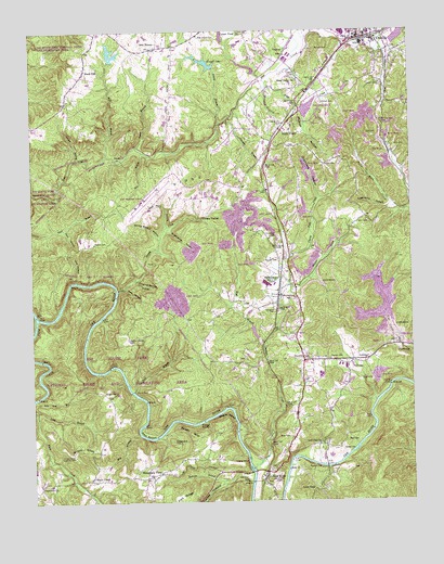
Oneida South, TN USGS Topographic Map
Click on map above to begin viewing in our Map Viewer.

This topographic map contains these locations and features:
Feature Name Type Latitude Longitude GNIS ID View Map
Ails BranchStreamN36.4679°W84.5883°1275510View Map
Bendix SpurRidgeN36.3934°W84.5738°1277000View Map
Big RidgeRidgeN36.4584°W84.5827°1277369View Map
Black CreekPopulated PlaceN36.3809°W84.6058°1277557View Map
Black Creek School (historical)SchoolN36.3798°W84.6063°1318755View Map
Black OakPopulated PlaceN36.4901°W84.6066°1277589View Map
Buttram BranchStreamN36.3829°W84.5533°1279203View Map
Carson CemeteryCemeteryN36.4806°W84.5283°1279758View Map
Carson CemeteryCemeteryN36.4853°W84.5097°1279759View Map
Carter DamDamN36.4884°W84.5516°1302623View Map
Carter LakeReservoirN36.4906°W84.5542°1302624View Map
Cecil CemeteryCemeteryN36.4101°W84.5202°1279988View Map
Cecil CemeteryCemeteryN36.4495°W84.5144°1279989View Map
Cecil HollowValleyN36.4477°W84.6143°1279991View Map
Chambers HollowValleyN36.4556°W84.5300°1280220View Map
Cherry Fork CreekStreamN36.4401°W84.5408°1280346View Map
Cherry Fork SchoolSchoolN36.4542°W84.5213°1280347View Map
Clear ForkStreamN36.4242°W84.6236°1305959View Map
Commissioner District 4CivilN36.4412°W84.5691°2464083View Map
Cooper PondLakeN36.4917°W84.5677°1281218View Map
Cooper PondLakeN36.4987°W84.5616°1281219View Map
Cordell CemeteryCemeteryN36.3884°W84.5233°1281290View Map
Cotton CemeteryCemeteryN36.4642°W84.5283°1281355View Map
Crossroads ChurchChurchN36.3795°W84.6227°1306202View Map
Dark HollowValleyN36.4318°W84.5944°1282055View Map
Dripping Springs HollowValleyN36.4339°W84.5910°1282804View Map
Duncan CemeteryCemeteryN36.4131°W84.5272°1283154View Map
Ellis HollowValleyN36.4338°W84.6105°1283690View Map
Fork RidgeRidgeN36.3767°W84.5763°1284630View Map
Grassy KnobSummitN36.3887°W84.6116°1285902View Map
Grassy Knob Lookout TowerTowerN36.3873°W84.6113°1647768View Map
Graveyard HillSummitN36.3909°W84.5788°1285972View Map
Greasy CreekStreamN36.4317°W84.5966°1286039View Map
Hazel Valley ChurchChurchN36.4867°W84.5374°1287261View Map
HelenwoodPopulated PlaceN36.4298°W84.5441°1287335View Map
Helenwood Baptist ChurchChurchN36.4292°W84.5408°1318771View Map
Helenwood Census Designated PlaceCensusN36.4287°W84.5532°2402576View Map
Helenwood Post OfficePost OfficeN36.4329°W84.5392°1651050View Map
Helenwood School (historical)SchoolN36.4287°W84.5408°1318772View Map
High PointPopulated PlaceN36.4754°W84.5419°1287704View Map
High Point Baptist ChurchChurchN36.4748°W84.5385°1318774View Map
Honeycutt CemeteryCemeteryN36.4456°W84.5444°1288215View Map
Huntsville Division (historical)CensusN36.4226°W84.5158°1648939View Map
Laurel BranchStreamN36.4754°W84.5633°1290705View Map
Lays DamDamN36.4917°W84.5983°1302630View Map
Lays LakeReservoirN36.4921°W84.5974°1302629View Map
Lick BranchStreamN36.4051°W84.5922°1291184View Map
Long BranchStreamN36.3992°W84.6233°1291892View Map
Low GapGapN36.3779°W84.5333°1292183View Map
Low Gap BranchStreamN36.4026°W84.6238°1292184View Map
Low Gap ChurchChurchN36.3904°W84.5311°1292186View Map
Marcum CemeteryCemeteryN36.4398°W84.5485°1292674View Map
Marcum CemeteryCemeteryN36.4945°W84.5258°1292675View Map
McCoy RocksCliffN36.3951°W84.5705°1293209View Map
Meadow BranchStreamN36.4867°W84.5499°1328878View Map
Mid - County Volunteer Fire DepartmentBuildingN36.4293°W84.5430°2654631View Map
Mill BranchStreamN36.3929°W84.5899°1293806View Map
Mill BranchStreamN36.4676°W84.5999°1293809View Map
Mountain ViewPopulated PlaceN36.3820°W84.5858°1294940View Map
Mountain View Baptist ChurchChurchN36.3817°W84.5861°1318786View Map
Nance BranchStreamN36.4695°W84.5902°1295213View Map
Negro BendBendN36.3965°W84.5613°1295331View Map
New HavenPopulated PlaceN36.4954°W84.5852°1295487View Map
New Haven Baptist ChurchChurchN36.4990°W84.5694°1318787View Map
New Haven CemeteryCemeteryN36.4987°W84.5697°1295489View Map
New RiverPopulated PlaceN36.3826°W84.5486°1295630View Map
New RiverStreamN36.4242°W84.6236°1295631View Map
New River Baptist ChurchChurchN36.3840°W84.5447°1318789View Map
New River Post OfficePost OfficeN36.3823°W84.5480°1651057View Map
New River School (historical)SchoolN36.3781°W84.5463°1318791View Map
Newport CemeteryCemeteryN36.3840°W84.5352°1295700View Map
Newport DamDamN36.4901°W84.5649°1302625View Map
Newport LakeReservoirN36.4917°W84.5676°1302626View Map
Niggs CreekStreamN36.4865°W84.5483°1295754View Map
Niggs Creek SchoolSchoolN36.4851°W84.5366°1295755View Map
North Fork Pine CreekStreamN36.4970°W84.5341°1329025View Map
OneidaPopulated PlaceN36.4981°W84.5127°1329062View Map
Panther BranchStreamN36.4659°W84.6099°1296724View Map
Pemberton CemeteryCemeteryN36.4256°W84.5452°1297133View Map
Phillips CemeteryCemeteryN36.4442°W84.6044°1297353View Map
Phillips CreekStreamN36.3845°W84.5533°1297355View Map
Phillips HollowValleyN36.4789°W84.5341°1297363View Map
Pike CemeteryCemeteryN36.4723°W84.5108°1297459View Map
Pine Creek Number One DamDamN36.4967°W84.5049°1302638View Map
Pine Creek Number One LakeReservoirN36.4991°W84.5028°1302637View Map
Ponderosa LakeReservoirN36.4794°W84.5334°1302615View Map
Ponderosa Lake DamDamN36.4801°W84.5349°1302616View Map
Reed BottomBendN36.3931°W84.5880°1299115View Map
Reed CemeteryCemeteryN36.3906°W84.5213°1299135View Map
Reed CemeteryCemeteryN36.3917°W84.5413°1299136View Map
Reed CemeteryCemeteryN36.4876°W84.5383°1299137View Map
Scott CountyCivilN36.4285°W84.5035°1639788View Map
Scott County Sheriff's DepartmentBuildingN36.4057°W84.5321°2766039View Map
Scott Municipal AirportAirportN36.4552°W84.5884°1301428View Map
Shoopmon CemeteryCemeteryN36.4128°W84.5341°1270158View Map
Silcott FordCrossingN36.4042°W84.5924°1314289View Map
Spring Branch HollowValleyN36.4449°W84.5826°1271058View Map
Sugarcamp HollowValleyN36.4471°W84.5804°1271720View Map
Sugarcamp HollowValleyN36.4535°W84.5064°1271721View Map
Sulphur CreekStreamN36.4317°W84.5397°1271774View Map
Sulphur Spring CemeteryCemeteryN36.4184°W84.5935°1271811View Map
Sulphur Spring SchoolSchoolN36.4126°W84.5547°1303924View Map
Thomas BranchStreamN36.4762°W84.5610°1272465View Map
Three ForksPopulated PlaceN36.4501°W84.5699°1314399View Map
ToomyPopulated PlaceN36.4670°W84.5944°1314415View Map
Town of HuntsvilleCivilN36.4106°W84.5039°2405876View Map
Tunnel Hill SchoolSchoolN36.4759°W84.5113°1272984View Map
Tunnel HollowValleyN36.3803°W84.5629°1272987View Map
VerdunPopulated PlaceN36.4948°W84.5408°1273425View Map
W H Swain DamDamN36.3967°W84.5199°1302569View Map
W H Swain LakeReservoirN36.3976°W84.5207°1302568View Map
West Branch Phillips CreekStreamN36.4176°W84.5480°1304458View Map
Wolf Fork HollowValleyN36.4482°W84.5805°1274958View Map
Wright CemeteryCemeteryN36.4042°W84.6016°1275170View Map

Note: Coordinates in the location and feature list above are referenced to NAD83 datum.


Copyright (C) 2008-2025 Ryan Niemi / Sunset Dynamics ... All Rights Reserved