TopoQuest Logo
Do you find TopoQuest useful?
Help keep TopoQuest running and adding new maps/features by donating!
Bitcoin:  19c7KJd3qBynnjoSw5npx9KScwjBe4ifkT
Litecoin:  LXs6TkuXGGXo1vDsWCkWVdjQX94eUKd6ui
Home View Maps Find Maps Find Places Resources & Links


Sharon East, Pennsylvania Topographic Map

USGS Map Title: Sharon East, PA
USGS Map MRC: 41080B4
DRG (GeoTIFF) Download: o41080b4.tif


Neighboring USGS Topographic Map Quads:


  Orangeville, OH  
41080C5
 

  Sharpsville, PA  
41080C4
 

  Fredonia, PA  
41080C3
 

  Sharon West, PA  
41080B5
 

  Sharon East, PA  
41080B4
 

  Greenfield, PA  
41080B3
 

  Campbell, OH  
41080A5
 

  Edinburg, PA  
41080A4
 

  New Castle North, PA  
41080A3


Map MRC Location:

N42°
W81°
N42°
W80°
H8 H7 H6 H5 H4 H3 H2 H1
G8 G7 G6 G5 G4 G3 G2 G1
F8 F7 F6 F5 F4 F3 F2 F1
E8 E7 E6 E5 E4 E3 E2 E1
D8 D7 D6 D5 D4 D3 D2 D1
C8 C7 C6 C5 C4 C3 C2 C1
B8 B7 B6 B5 B4 B3 B2 B1
A8 A7 A6 A5 A4 A3 A2 A1
N41°
W81°
N41°
W80°

Sharon East, PA USGS 1:24K Topographic Map Preview:
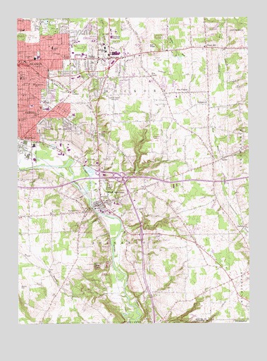
Sharon East, PA USGS Topographic Map
Click on map above to begin viewing in our Map Viewer.

This topographic map contains these locations and features:
Feature Name Type Latitude Longitude GNIS ID View Map
Bartman Elementary SchoolSchoolN41.2381°W80.4515°1213817View Map
BethelPopulated PlaceN41.1926°W80.3884°1169354View Map
Beulah CemeteryCemeteryN41.1412°W80.4742°1169446View Map
Bobby RunStreamN41.1892°W80.4709°1169924View Map
Bobbys CornersPopulated PlaceN41.2014°W80.4559°1169926View Map
Borough of West MiddlesexCivilN41.1742°W80.4556°1215451View Map
Borough of WheatlandCivilN41.1970°W80.4958°1215452View Map
Buhl LakeLakeN41.2486°W80.4842°1170628View Map
Buhl ParkParkN41.2459°W80.4778°1170629View Map
CarbonPopulated PlaceN41.1645°W80.3776°1171188View Map
Central ChurchChurchN41.2301°W80.4681°1171465View Map
City of FarrellCivilN41.2113°W80.4971°1215437View Map
City of HermitageCivilN41.2309°W80.4412°1215441View Map
City of SharonCivilN41.2340°W80.4998°1215447View Map
Dutch HillPopulated PlaceN41.2378°W80.3967°1173652View Map
Eckles SchoolSchoolN41.2103°W80.4903°1173974View Map
Elite EMSBuildingN41.2342°W80.4431°2780636View Map
F M CornersPopulated PlaceN41.2198°W80.4709°1174398View Map
Fairview CemeteryCemeteryN41.2075°W80.4867°1174499View Map
FarrellPopulated PlaceN41.2123°W80.4967°1192451View Map
Farrell Area High SchoolSchoolN41.2128°W80.4853°1211688View Map
Five PointsPopulated PlaceN41.2262°W80.4267°1174869View Map
Furnace HillPopulated PlaceN41.1706°W80.4656°1175351View Map
Gamble SchoolSchoolN41.2453°W80.4962°1175403View Map
Hadley SchoolSchoolN41.2381°W80.4803°1176356View Map
Hann HillPopulated PlaceN41.2106°W80.4470°1176461View Map
HermitagePopulated PlaceN41.2334°W80.4487°1176876View Map
Hermitage AirportAirportN41.2022°W80.4228°1194190View Map
Hermitage Fire Department Station 1 HeadquartersBuildingN41.2399°W80.4632°2645256View Map
Hermitage Fire Department Station 3BuildingN41.2257°W80.4596°2645691View Map
Hermitage Post OfficePost OfficeN41.2328°W80.4473°2772974View Map
Hermitage SchoolSchoolN41.2364°W80.4512°1176877View Map
Hickory CornersPopulated PlaceN41.2334°W80.4553°1176952View Map
Hickory High SchoolSchoolN41.2351°W80.4495°1176960View Map
Hillcrest Memorial ParkCemeteryN41.2373°W80.4595°1177092View Map
Hogback RunStreamN41.1820°W80.4676°1177176View Map
Holy Trinty CemeteryCemeteryN41.2059°W80.4653°1177313View Map
Jefferson SchoolSchoolN41.2345°W80.4951°1178023View Map
Keel RidgeRidgeN41.2378°W80.4262°1178282View Map
McGonigle Ambulance ServiceBuildingN41.2338°W80.4794°2719643View Map
Morefield CemeteryCemeteryN41.2267°W80.4609°1181538View Map
Musser Elementary SchoolSchoolN41.2256°W80.4978°1213883View Map
NeshannockPopulated PlaceN41.2159°W80.3959°1182262View Map
New VirginiaPopulated PlaceN41.2195°W80.4062°1182378View Map
Oakland Avenue ChurchChurchN41.2356°W80.4990°1182826View Map
Oakland StationLocaleN41.2195°W80.4201°1212728View Map
Oakland Station (historical)LocaleN41.2173°W80.4259°1206193View Map
Oakwood CemeteryCemeteryN41.2420°W80.4978°1182853View Map
Pargney SchoolSchoolN41.2084°W80.4987°1183292View Map
Prospect SchoolSchoolN41.2262°W80.4978°1184464View Map
Saint Alberts SchoolSchoolN41.2176°W80.4998°1217457View Map
Saint Annes CemeteryCemeteryN41.2053°W80.4670°1185773View Map
Saint Anthonys CemeteryCemeteryN41.2045°W80.4678°1185789View Map
Saint Anthonys CemeteryCemeteryN41.2092°W80.4720°1185790View Map
Saint Anthonys ChurchChurchN41.2164°W80.4942°1185792View Map
Saint Elizabeths CemeteryCemeteryN41.2150°W80.4820°1185925View Map
Saint Johns CemeteryCemeteryN41.2245°W80.4498°1186078View Map
Saint Johns ChurchChurchN41.2228°W80.4967°1186161View Map
Saint Marys CemeteryCemeteryN41.2034°W80.4648°1186398View Map
Saint Pauls ChurchChurchN41.2356°W80.4770°1186629View Map
Saint Stanislaus CemeteryCemeteryN41.2064°W80.4665°1186720View Map
SharonPopulated PlaceN41.2331°W80.4934°1193328View Map
Sharon Airport (historical)AirportN41.2153°W80.4512°1194195View Map
Sharon High SchoolSchoolN41.2337°W80.4901°1211687View Map
Sharon Regional Health SystemHospitalN41.2323°W80.4959°2718080View Map
Shehango Township Volunteer Fire Department Station 79 2BuildingN41.1635°W80.4082°2645799View Map
Shenango Township Mercer County Police DepartmentBuildingN41.1693°W80.4809°2780463View Map
Shenango Township Volunteer Fire Department Station 79BuildingN41.1694°W80.4806°2645822View Map
Slovak CemeteryCemeteryN41.2262°W80.4634°1187837View Map
Stony HillSummitN41.1378°W80.4981°1188775View Map
Thornton SchoolSchoolN41.2495°W80.4965°1189533View Map
Township of ShenangoCivilN41.1575°W80.4516°1216818View Map
Trouts CornersPopulated PlaceN41.2334°W80.4709°1198233View Map
Turkey RunStreamN41.1362°W80.4412°1189946View Map
University of Pennsylvania Medical Center Horizon Shenango ValleyHospitalN41.2105°W80.4694°2718129View Map
VFW Golf CourseLocaleN41.2334°W80.4240°1205591View Map
Wengler Avenue SchoolSchoolN41.2231°W80.4906°1190829View Map
West MiddlesexPopulated PlaceN41.1742°W80.4534°1200129View Map
West Middlesex Post OfficePost OfficeN41.1728°W80.4579°2773031View Map
West Middlesex Volunteer Fire Department Station 74BuildingN41.1745°W80.4556°2645349View Map
WheatlandPopulated PlaceN41.2009°W80.4978°1191212View Map
Wheatland Post OfficePost OfficeN41.2010°W80.4928°2780011View Map
Wheatland Volunteer Fire Department Station 72BuildingN41.2010°W80.4967°2645350View Map
WPIC-AM (Sharon)TowerN41.2195°W80.4734°1200488View Map
WYFM-FM (Sharon)TowerN41.2195°W80.4734°1200295View Map

Note: Coordinates in the location and feature list above are referenced to NAD83 datum.


Copyright (C) 2008-2025 Ryan Niemi / Sunset Dynamics ... All Rights Reserved